|
RÍO COLCA: Lunar Canyon and Chocolate Canyon |
|
50-170 km (30-100 miles), class V, 7-8 days |
| launches: May9 (2023) RESERVE |
| OTHER TRIPS |
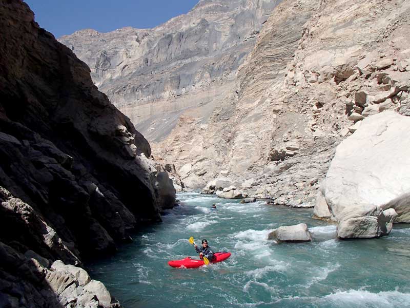
Río Colca is one of the most celebrated rivers in the world - a coastal desert river in Southern Peru that runs through the second deepest canyon of South America. On this kayak trip (possibly with 1-2 rafts along), you'll be challenged by class III and IV rapids on a clear river fed by the springs of Río Mamacocha. Compared to the Cotahuasi, Río Colca has bigger water, is more gorged-in, and has no archaeological ruins, but overall is about the same difficulty (while both are more difficult than the neighboring Río Tambo).
| INTRODUCTION |
| ITINERARY |
| GUIDES |
| TRIP COST |
| SAFETY & HEALTH |
| FOOD, ALCOHOL, WATER |
| CHORES, TOILET, BATHING |
| WHAT TO PACK |
| CLIMATE |
| WATER LEVELS |
| PARTICIPANT COMMENTS |
| ----------------------------- |
| RIVER MAPS |
| OUTFITTING SERVICE |
| Slideshow: Colca2014 |
Río Colca was first descended by the CanoAndes crew in 1980 in one of the boldest first descents ever completed. The river canyon has since held the aura of one of the most impressive and challenging multi-day river expeditions in the world. Our group will challenge the desert rapids of the river during the more manageable steady lower water time of year. Enjoy the eerie Lunar Canyon and Chocolate Canyon scenery as you navigate fun class IV rapids and figure out how to get around the nasty boulder-choked sections of Reparaz and Cañon de los Polacos. We will end by paddling 1-3 days down the larger easier Río Majes where you can cruise in a more relaxed manner and have the option of completing the full 170 km journey to the Pacific Ocean.
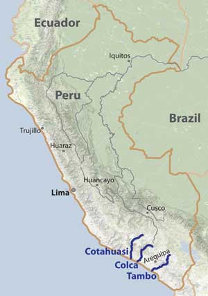
Consider also joining trips on the neighboring Cotahuasi (about the same difficulty) and/or Tambo (less challenging) - discounts provided if sequential trips done. [If the majority of the group is doing consecutive trips, itinerary changes may be made to facilitate paddling both rivers in 12-14 days.]
COLCA SECTIONS:
The Colca has several sections. You can read a bit about them at Kurt Casey's www.PeruWhitewater.com website.
| section | km | days | class | note | |
| Headwaters | 60 | 3 | III-IV | mountain source to Embalse Chojo | |
| Altiplano | 75 | 3 | III-IV | Embalse Chojo (4120 m) to Tuti diversion (3840 m) | |
| Valle Colca | 50 | 3 | IV-V (P) | Tuti (3840 m) to Madrigal exit (3000 m) | |
| Cruz del Condor | 17 | 1 | VI | not runnable; gorged-in class VI | |
| Upper Colca | 32 | 3 | V | starts at Oasis (2200 m) through Cataratas Juan Pablo II | |
| Cañon de la Luna | 49 | 3 | IV+ | the standard run; many gorges; deepest canyon | |
| Andamayo | 76 | 2 | III-IV | open with some road access, fun class III-IV | |
| Majes | 55 | 1 | II-III | road access, class II-III |
====================================================================================
Upper Colca
class V
33 km (20 miles) ; 3 days
Oasis (2200 m) to Canco (1400 m)
24 m/km (133 ft/mile)
The Upper Colca section of the river is named because it is the kayakable class V upstream section to the more friendly "Main Colca" which is the Cañón de la Luna (Lunar Canyon). The CanoAndes crew amazingly did the first descent in 1981 with a raft and 2 fibeglass kayaks, taking 11 days for just this section of river (lots of portages). By today's standards, the section is generally condsidered runnable class V with several portages (usually 3-7), some of which are difficult [see Video_UpperColca]. During much of the dry season, due to the high diversions from Tuti upstream, this section has very little water and possibly not enough to merit paddling it. It should have enough water usually April into May and sometimes not too much Jan-Mar. On SierraRios trips, depending on the groups ability and desires and the flow of the river, some of the group may attempt to paddle this section.
Cañon de la Luna
class IV+
44 km (28 miles) ; 3 days
Canco (1400 m) to Andamayo take-out (900 m)
11.3 m/km (63 ft/mile)
The Lunar Canyon section of Río Colca flows through what some consider to be the deepest canyon in South America. The eerie landscape has earned sections of it the names "Lunar Canyon" and also "Chocolate Canyon" and some just referring to it as "Lunar Canyon". Entering the canyon at Canco generally requires a mule or burro-assisted descent from Huambo during the first day, though a road being built to Canco is helping shorten the trail. The section is filled with numerous class III and IV rapids, as well as several Vs. The scenery is fantastic, and there are some interesting excursions which will prompt us to spend a bit more time in here. Three class V-VI passages in the lower part (Reparaz and Cañon de los Polacos) are very dangerous and require portages. Only boaters with adequate IV+ skills should attempt to paddle this section. However, with skilled class V guides, anyone can join this expedition on a raft. The section continues down to where the gorges open up and road access first appears near Andamayo.
Andamayo (Lower Colca)
class III-IV
55 km (34 miles) ; 1 day
Andamayo (790 m) to Puente Escarilla (380 m)
7.5 m/km (41 ft/mile)
The Andamayo section is named for Andamayo, the village at the mouth of the main Lunar Canyon. On this section, the river flows into even drier terrain of the Atacama desert - entirely within canyon but also with some irrigated fields in many parts of the low riverbed and passing occasional villages such as Aplao. A road gives access to the river in many places - most easily at occasional bridges, but there are still nicely isolated beaches to camp on and the scenery remains stunning. SierraRios trips will generally paddle all of this section since it continues to have very fun rapids and is an interesting and more relaxing change from the more intimidating gorges upstream. If you're traveling with non-boater friends who only want to join you for a day or two on the river, this is a great section to have them accompany you in a raft.
Majes
class III
67 km (24 miles) ; 1-2 days
Puente Escarilla (380 m) to the mouth (0 m)
5.7 m/km (31 ft/mile)
The Majes section is named for the main river name here: Río Majes, which is also one of the largest Pacific drainages in Peru. On this section, the river flows into even drier terrain of the Atacama desert but also gets more fog and humidity. One long section in here is farther removed from the road and very pleasant to paddle. There are still frequent class II rapids and an occasional III, so it is a great section to boogie down quickly, have friends accompany you on rafts, or have you or others try out rowing or kayaking. One unusual hazard to beware of are the langostino traps set up at certain times of the year. Camps are possible almost anywhere, and resupply is possible at various villages along the way. The section ends at the Pacific Ocean by the town of Camaná, which can be a very satisfying feeling to arrive at and have a final celebratory drink. SierraRios trips will normally not be planned to continue through this section, but it's always possible to arrange to do it or meet friends here.
====================================================================================
PRIOR DESCENTS:
Río Colca has had many descents over the years:
CanoAndes et al., 1981: In one of the boldest first descent expeditions ever attempted and completed, a group of Polish river runners (including Piotr Chmielinski and Andrejz Pietowski) made the first descent of the river from near the Oasis to Aplao over 11 days at low water with a bucket raft and some fiberglass kayaks. The group celebrated the 25th anniversary by convening at Canco in summer 2006.
Other private trips: At least a dozen other private kayak groups have descended the river (e.g., see KurtCasey's Report, also HERE) though these trips are rare due to the difficulties and expenses of getting kayaks there and organizing logistics including the burros into Canco.
Commercial trips: Commercial outfitters only run raft trips and generally the river has seen about 1-2 per year since the 1980s when the first one was done. Outfitters include Amazonas Explorer, Bio Bio, Expediciones y Aventuras, and Cusipata - each charging ~$2000-$3000 for the trip of 5-8 days.
Personality/Experience/Leadership:
You should be comfortable camping and you should have an easygoing attitude in order to get along with a diverse group on a multi-day trip for an extended period. If you are concerned about this issue, consider arranging a private trip through our Outfitting Services. This trip is primarily geared to experienced class IV kayakers. However, we may accommodate some oarsmen or raft passengers/paddlers depending on circumstances. Those wishing to row must be class V rafters and have significant exprerience on similarly difficult small continuous rivers. Passengers with limited experience are welcome to join, but the pricing may be a bit higher due to the need to employ guides who can safely assure your passage.
Everyone joining SierraRios trips should have an interest in river conservation and help us on our mission to document the river further, talk to residents, and publicize the planned dams. We welcome competent boaters. To join the trip as a kayaker, you must have adequate class IV+ experience and a solid roll. If you want to row a raft, you must have adequate experience rowing class V rivers. You should be in good physical condition. You should plan to help facilitate the trip in any way possible, including transport of some gear down to Peru and to the river if necessary. You don't need to be bilingual but it is helpful and more fulfilling to communicate with local residents when we meet them.
The policy we will take on the trip is that the trip leader will have main authority when it comes to decisions for the group regarding river progress, camp, etc. If a participant has overestimated their ability to row or kayak, he/she may be mandated to ride on a raft and or be assessed other penalties and in severely incompetent situations, not allowed on the multi-day part of the trip. Trip leader decisions can be vetoed by a majority vote of the group. Any participant always has the right to leave the trip if they so desire.
RENDEZVOUS POINTS/TRANSPORTATION
AREQUIPA: The main rendezvous point at the start of the trip will be Arequipa. You should arrive 1-2 days before the launch date. To get to Arequipa from Lima, you can fly (1.5 hr) or take a bus (15 hr). Flights are operated by STAR, LAN, PeruvianAir, and/or LC Peru. We will arrange transportation for the ~6 hr drive to Cabanaconde where we'll likely stay the first night before getting to the river. Depending on the group's desires, we may even allow a day to hike down to the Oasis and back (bottom of the Colca canyon and a popular tourist activity).
Other Sites/Excursions: Arequipa is a beautiful colonial city at 2200 m elevation in the Atacama desert but high enough to get a bit of precipitation. You might consider doing several days hiking/trekking before the trip, such as up one of the nearby volcanos. You can also test your kayak and make modifications to it by running Río Chili (class III-IV), the popular commercial raft run that ends in the city. There are other things to see/do in and around Arequipa. Consider visiting the plaza and churches/covents/museums in the main city [one of which houses a mummified pre-Incan "Juanita" woman found at the top of one of the local volcanoes (Ampato)], paddling a day trip on Río Chili, climbing some of the many volcanoes in the area (Misti, Chacani, Corpuna, Sabancaya), or visiting the most distant undammed source of the Amazon (Mt. Mismi). You should also consider lengthening your stay to do another expedition before or after this trip - on the Tambo and/or Cotahuasi (special lower rates if two trips are done sequentially). Furthermore, Arequipa is fairly close to two very popular destinations in southern Peru: Puno (6 hr by bus) - a charming colonial town on the shores of Lago Titicaca where most tourists visit the floating islands of Uros and other sites in the area, and Cusco (10 hr by bus or <1 hr by flight), the former Incan capital near the Sacred Valley of the Incas and Machu Picchu.
TENTATIVE ITINERARY (default) :
Day 0: rendezvous in Arequipa; meet trip leader
Day 1: Cancco: drive by Cabanaconde and new road down to Cancco; rig; camp; hot springs
Day 2: Lunar Canyon: paddle first part of the river; play in crystalline waters of Mamacocha; ~15 km; class IV+
Day 3: Lunar Canyon: Pass several IVs & Vs; Hotsprings; 1st Portage; Ducha del Condor; ~15 km; class IV+(P)
Day 4: Chocolate Canyon: Make it through Reparaz and Cañon de los Polacos; camp just past; ~8 km
Day 5: Chocolate Canyon: paddle more open class III-IV section down past Andamayo; Río Majes; 50 km
Day 6: Majes; optional boogie class III, possibly to mouth; derig; ride back to Arequipa; 50 km
Day 7: Majes; optional boogie class III, possibly to mouth; derig; ride back to Arequipa; 50 km
Note: some trips may end just after we reach the lower road access on the Majes (~50 km); other trips may continue through much of the easy fun and fast Río Majes, perhaps all the way to the ocean (120 km extra; ~2 days). What we do depends on the group and how long it takes to get through the main Chocolate Canyon section with the portages.
ALTERNATE ITINERARY (strong crew; all kayaks):
Day 0: rendezvous in Arequipa; meet trip leader
Day 1: possible warm-up on Río Chili (class III-IV); take bus and/or vans to Cabanaconde
Day 2: Juan Pablo II Canyon: drive to river by Cabanaconde; launch; self-support; ~10 km; class V
Day 3: Juan Pablo II Canyon: more serious rapids; portage Cascadas Juan Pablo II; self-support; ~10 km; class V
Day 4: Lunar Canyon: pass Canco; play in crystalline waters of Mamacocha; ~15 km; class IV+
Day 5: Lunar Canyon: gorges and big rapids; side hike; Chocolate Canyon; Ducha del Condor; ~20 km; class IV
Day 6: Lunar Canyon: make it through Reparaz and Cañon de los Polacos; ~15 km
Day 7: Andamayo: paddle more open class III-IV section down to near Aplao; ride back to Arequipa; 40 km
Expected Progress:
We will generally paddle from ~9 am to 4 pm with some stops for side hikes and at interesting locales. The main expedition part of the trip will last ~5 days and involve getting to Canco and paddling down Río Colca to Aplao. We may or may not have a raft along for support in this section. If we do not, you will be advised on packing camping gear and food into you kayak. If we do, it will take longer to get the raft through the difficulty passages. Depending on the group's goals and the presence of rafts, with the additional days we will have several choices: paddle the difficult class V section down to Canco (2-3 days), hike into El Oasis from Cabanaconde (a popular tourist activity), paddle Río Chili and/or Río Mamacocha, or paddle all the way to the ocean. In all cases, on the final day we will derig and get a ride back to Arequipa.
Maps:
Members can access maps of the river HERE with appropriate pass codes. SierraRios has all topo maps of the entire river marked with rapids and potential beach camps. If you would like access to these, you can sign up as a member of SierraRios specifying you're interested in the Cotahuasi map/book/video, and you'll receive immediate access to the maps (book/DVD later). [also note links at top left column of this page and at TOPO MAPS on the main www.SierraRios.org homepage.]
CLIMATE AND BUGS:
The trip occurs at tropical latitudes in desert country and at moderate to low elevation. Average annual precipitation is <200 mm (7 in) from the start at Canco and decreases to almost nothing at the coast. The elevation at the put-in is 1400 m (4640 ft), so expect cool days and cool evenings on most of the trip (highs of 21oC/70oF and lows of 14oC/56oF are common), with humidity and fog increasing close to the ocean. Being the heart of the Atacama desert, there is almost never any rain on this trip. On most of the river the water is usually clear and cool (16-20oC) so a drytop is recommended. Rafters will be comfortable with splash pants and a paddle jacket or drytop which can be removed when sunny and hot out.
CLIMATE: The climate averages for Arequipa (2400 m elevation), Ica (400 m elevation) and the average flow of the river at Huatiapa are shown below.
| AQP (2400m) | Jan | Feb | Mar | Apr | May | Jun | Jul | Aug | Sep | Oct | Nov | Dec | Avg |
| AvgHigh(F) | 71 | 70 | 71 | 71 | 71 | 70 | 70 | 71 | 72 | 73 | 73 | 72 | 71 |
| AvgLow(F) | 48 | 48 | 47 | 44 | 43 | 42 | 42 | 42 | 43 | 44 | 44 | 46 | 44 |
| AvgRainDays | 5 | 5 | 2 | 0 | 0 | 0 | 0 | 0 | 0 | 0 | 0 | 0 | |
| AvgPrecip(mm/in) | 1.1 | 1.4 | 0.8 | 0.0 | 0.0 | 0.0 | 0.0 | 0.1 | 0.1 | 0.1 | 0.0 | 0.1 | 3.7 |
| ICA (400 m) | |||||||||||||
| AvgHigh(F) | 85 | 85 | 84 | 81 | 75 | 72 | 70 | 70 | 72 | 73 | 75 | 79 | 77 |
| AvgLow(F) | 68 | 68 | 68 | 64 | 59 | 57 | 57 | 57 | 57 | 59 | 61 | 64 | 63 |
| AvgRainDays | 1 | 1 | 0 | 0 | 0 | 0 | 1 | 0 | 2 | 0 | 0 | 0 | |
| AvgPrecip(mm/in) | 0.1 | 0.1 | 0.0 | 0.0 | 0.0 | 0.1 | 0.2 | 0.1 | 0.4 | 0.0 | 0.0 | 0.1 | 1.1 |
| RíoColca(Huatiapa) | |||||||||||||
| AvgFlow(cfs) | 5300 | 8900 | 7500 | 4300 | 2300 | 1560 | 1350 | 1200 | 1050 | 1000 | 1050 | 2200 | 2950 |
BUGS/UV: UV rays from the sun are intense so it is recommended that you use sunblock liberally. Note that in many camps there are annoying biting gnats and sometimes larger biting flies. Use repellent or wear light clothes that cover your body. Mosquitos are almost non-existent. Other critters to beware of are spiders, scorpions, snakes, and centipedes. You should especially be cautious of the assassin bugs which can bite and trasmit Chagas Disease, a malady endemic to the area (i.e., best prevention is to sleep in a tent!).
COST
This trip is being run because it is one of the most incredible in the world and more paddler visitation is needed to help raise awareness. More ecotourism income to the region and appreciation of the natural resource will help stop the river's destruction with dams. This trip is primarily for kayakers but some rafters are welcome to join as well. Note that if you join a sequential trip based out of Arequipa you will get a significant discount on the second trip. Our general pricing guidelines are found at the following link: Contribution guidelines: General
Special discounts are sometimes offered to folks on our email list, so you are encouraged to sign up (Email List info).
RESERVATIONS
You will need to provide a deposit to reserve your place on the trip ($500). Please email a note about you and your intent to join the trip to reservations@sierrarios.org. Full contribution must be received at least 2 weeks before the trip. See PAYMENTS for payment options and cancellation policy. Trips may be cancelled 3 months before launch if there is not enough interest (6-8 paying participants will assure a trip occurs).
TRIP LEADER AND TEAM MEMBERS:
(1) Rocky Contos (scheduled trip leader on first trips of 2015), kayaked all of Río Cotahuasi and Colca in 2014 and did the first descent of the neighboring Río Tambo in 2013. In 2012, Rocky paddled all of Ríos Mantaro, Apurímac, Urubamba, and Marañon as part of his Headwaters of the Amazon expedition. He discovered the most distant source of the Amazon [see articles C&K, Outside, Nat.Geo, FoxNews, LaRepublica]. He has explored nearly every river in Mexico including >100 first descents covering ~8,000 km of river and ~55,000 m of drop. Rocky is fluent in Spanish and has organized many Grand Canyon length trips. Several articles have featured Rocky (American Whitewater; Kayak Session; Canoe & Kayak). While attaining his Ph.D. in neuroscience (see CV), Rocky worked as a kayak instructor and guide for UCSD's Outback adventures from 1993-1996 and gained valuable trip planning skills for large groups. Although primarily a kayaker, Rocky started rafting in the mid-1990s in order to introduce more people to the wonders of river travel. Since then and throughout his years as a postdoctoral research associate, he organized and led numerous large group raft and kayak expeditions, including five through Grand Canyon (18-22 days), three on the Salmon River (4-10 days each), two on Río Mulatos-Aros (8-11 days), eight on Río Usumacinta (7-8 days each), eight on Río Marañon (14-30 days each), and dozens to destinations such as the Salt, Kern, Rogue, Deschutes, John Day, Thompson, Similkameen, and Baja California (2-6 days each). Rocky founded SierraRios with the goal of conserving the rivers of Latin America, and hopes that increased awareness and enjoyment of the resource will lead to protection. He is organizing all aspects of the trip. He likely will be kayaking but may row a raft.
(2) Other guides/trip leaders are to be decided, but likely will be selected from Rocky's Peruvian guide friends - Pedro Peña, Julio Baca, Victor Baca, Alonso Campana, Victor Memdivi (Bacteria), others from Apurimac Explorer, or possibly Daniel Rondón, Gustavo Rondón or others from Expediciones y Aventuras.
(3) All oarsmen will be experienced river runners and raft captains will be guides with extensive experience. Non-experienced and less-experienced participants are welcome to inquire about joining as raft paddlers/passengers.
FOOD/ALCOHOL/WATER
(click here)
CHORES, TOILET AND BATHING
(click here)
WHAT TO PACK
(click here)
SAFETY/HEALTH
A major aspect of safety on this trip is prevention of sickness and accidents. It is of utmost importance that you take all precautions necessary to avert sickness and complications while on the trip. For example, it is a good idea to be vaccinated against Hepatitis A, Typhoid, and Tetanus [however, no vaccines are required].
All participants must assume responsibility for themselves and sign a liability waiver before the trip. We cannot guarantee against accidents. If you're an inexperienced boater, the trip leader and guides will advise you on saftey issues. If you are an experienced boater in control of your craft, you must accept the responsibility for what happens to you on the river. It is the experienced boater's responsibility to make appropriate decisions whether to run the rapid or not and to stay close to someone who can watch and oversee you. A certain level of freedom will be provided, but each such person must abide by trip leader requests, which may mandate not paddling certain rapids. If an accident occurs, we will do all in our power to help you, see that proper care is rendered, or evacuate you if need be.
We will have an Inmarsat satellite phone ($1.50/min for calls) and possibly a SPOT device. Anyone can see the latest SPOT position of the SierraRios trip if we utilize it.
Río Colca is runnable all year and normally has ~2X as much water as Río Cotahuasi. It is gorged-in more so can seem more intimidating when both rivers are run sequentially. Like all rivers in the region, the Colca has its highest levels from Jan-Apr, which is the rainy season when the river often floods from rains in the mountains. During May through November the river is generally stable and slowly dropping. For ~40 years the river's flow has been dramatically reduced due to diversions to the Majes Valley (at Tuti; >3000 m elevation). Just in the past 15 years these diversions have been increased, leading to a very low flow from Jun-Nov in the river between Tuti and Canco. This may be an even higher percentage when additional diversions to the Majes valley are realized in the near future, making the river almost unfloatable above the Mamacocha in the dry season. In the low water season, a large fraction of the water in the main Lunar Canyon (and at Huatiapa) is contributed from the springs that feed Río Mamacocha [usually ~50% of the water (20-40 cfs depending on the month)]. The planned diversion of Río Apurimac into the Colca is due to be completely alloted to the Majes valley and is not expected to improve the situation. A planned diversion and possibly hydro project of the Mamacocha's water would dewater the Colca to nearly unboatable flows for much of the year.
| river | Ene | Feb | Mar | Abr | May | Jun | Jul | Ago | Sep | Oct | Nov | Dic | - | Avg | |
| Colca (Huatiapa) | cms | 150 | 250 | 210 | 120 | 65 | 44 | 38 | 34 | 30 | 28 | 30 | 60 | - | 85 |
| cfs | 5300 | 8900 | 7500 | 4300 | 2300 | 1560 | 1350 | 1200 | 1050 | 1000 | 1050 | 2200 | - | 2950 | |
| ---------------------------- | ----- | -------- | -------- | -------- | -------- | -------- | -------- | -------- | -------- | -------- | -------- | -------- | -------- | - | -------- |
BOATS AVAILABLE IN PERU:
[current list available]
Some boats currently in Bolivia may also be available: Mamba8.1, Diesel80, FlyingSquirrel85.
A FEW COMMENTS FROM PAST PARTICIPANTS:
"XX."
X, class V rafter/IKer .