|
RÍO CHAYANTA-GRANDE: Grand Canyon of Bolivia |
|
635 km (394 miles), class IV, 9+11 days (20 days for full expedition) |
| launches: Mar10 (2024) RESERVE |
| OTHER TRIPS |
Río SanPedro-Grande is the most distant source of Río Madeira, the largest tributary of the Amazon. On this expedition, we'll start at an altitude of 2840 m (9300 ft) and navigate downstream on muddy water through a Grand Canyon cut out of the Andes with puno, desert, and jungle ecosystems. We'll camp on fine beaches, explore slot side canyons, find Incan ruins, visit local residents, admire the changing flora and fauna, and visit Che Guevarra's last outpost. Compared to the nearby Pilcomayo, the Grande has over twice the volume, with similarly spectacular gorges, and true Amazon jungle in its lower reaches.
| INTRODUCTION |
| ITINERARY |
| GUIDES |
| TRIP COST |
| SAFETY & HEALTH |
| FOOD, ALCOHOL, WATER |
| CHORES, TOILET, BATHING |
| WHAT TO PACK |
| CLIMATE |
| WATER LEVELS |
| PARTICIPANT COMMENTS |
| ----------------------------- |
| PETITION (help save the rio) |
| Photos: 2015-16 |
| Photos: 2017a :2017b : 2017c |
| Video: 2016a : 2016b : 2018a |
| OUTFITTING SERVICE |
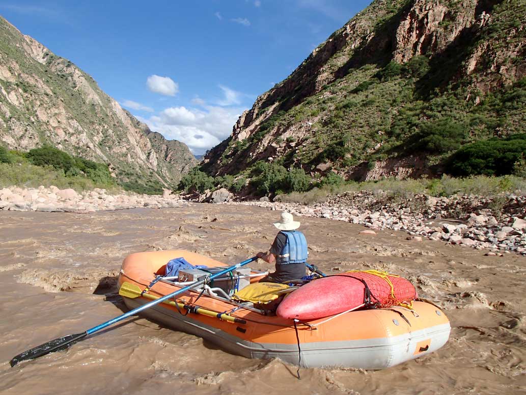
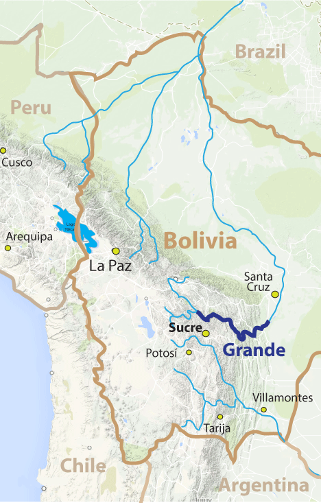
Río Grande is formed by the confluence of two major rivers (Ríos Caine and Chayanta-San Pedro) draining a large chunk of the altiplano of Bolivia. The river is the largest Andean river in Bolivia and ideal for rafting as it flows with moderate gradient with plenty of water through a long, impressive and remote canyon to the end of the Andes with maximum class IV rapids. The trip can be divided into two ~10 day sections: the first 246 km on Ríos Chiuta-Chayanta-San Pedro to Puente Arce (class IV), after which we'll have a layover / resupply day in Sucre, and then the second 389 km section (class IV) where we will continue downstream through the desert and jungle sections of Río Grande to Abapó (by Santa Cruz). Most days will be class III, but about six days have signif icant class IV rapids. This trip is comparable to the Marañón in many ways. See PHOTOS (2016).
Join us for a raft/kayak descent of this Grand Canyon style river in Bolivia and experience one of the few tropical wilderness rivers that remain in the world! See a range of ecosystems as you descend from puno scrubland to high forest to arid desert and finally into lush Amazon jungle and feel the soft warm muddy water that gives life to much of the Amazon downstream. Admire the wildlife, including parrots, capybara, and condors (we pass through the highest density area of Andean condors in the world)! Visit La Higuera, the last area Che Guevarra was rounding up revolutionaries when he captured and executed. Help us in our mission to publicize the canyon to increase visitation and provide more reasons to keep the river free-flowing without the planned 140 m-high Rositas Hydroelectric Dam project at the end of the river. Sign the PETITION.
You might also consider joining a similar raft-support descent on the other Grand Canyon of Bolivia on the nearby Río Pilcomayo.
| VIDEOS | |
| Azero-Grande (2018) [high water] | |
GRANDE SECTIONS:
The Río Chayanta-SanPedro-Grande trip can be divided into several sections based on access points. Full descent trips will have a potential passenger exchange at Puente Arce (Sucre) about midway through the full expedition before the Grande (Main) section:
| section | km | days | class | elevation | m/km | fpm | note |
| Chiuta | 37 | 1 | V | 3280-2840 m | 11.9 | 65 | expert kayakers only; awesome gorges and rapids |
| Chayanta | 111 | 5 | IV | 2840-1850 m | 9.0 | 50 | fantastic raftable green canyon; continuous class II and III |
| SanPedro | 98 | 4 | III | 1850-1500 m | 3.6 | 20 | easy section with incredible gorge to Caine confluence |
| Grande(Main) | 159 | 5 | IV+ | 1500-910 m | 3.7 | 20 | into arid canyon with sets of intimidating rapids; condors |
| Grande(Lower) | 230 | 5 | III | 910-420 m | 2.0 | 11 | into jungle canyon with sets of class III rapids (one IV) |
====================================================================================
Chiuta section
class V
37 km (23 miles) ; 1 day
Puente Morochaca (3280 m) to Tacarani (2840 m)
11.9 m/km (58 ft/mile)
avg flow 50 cms (Feb)
The Chiuta section has an easily accessible put-in by a highway bridge across the river and goes through some amazing gorges with fun class IV-V rapids that will keep all kayakers pleased. Some of the gorges form incredible narrows. Due to the smaller river, higher gradient and difficult rapids, this section is only suitable for expert kayakers and will not be planned for the main rafting group (though the section may be an option for capable kayakers to complete).
Chayanta section
class IV
111 km (69 miles) ; 5-6 days
Tacarani (2840 m) to Puente SanPedro (1850 m)
6.8 m/km (37 ft/mile)
avg Feb flow 70 cms (2500 cfs) @ start; 140 cms (5000 cfs) just before San Pedro confluence 260 cms (9200 cfs) after
The Chayanta section consists of Río Chayanta and is a moderate gradient section of river accessible at roads at Tacarani and at the San Pedro confluence. The river is very remote in the high Bolivian Andes and one of the few in the world where you can start at such a high elevation (2840 m = 9310 ft) and continuously raft down to sea level without class V rapids or portages. The current is swift the entire way with nearly continuous class I-II water and occasional tougher rapids. The most difficult rapids are found at Barranca Chacafaya, where a long steep gravel/rock class III-IV section adds up to a solid class IV. The scenery is gorgeous on the trip and most of the way there are huge beaches and gravel bars making for excellent camps. The Quechua-speaking people along the way have been very friendly to us. The section ends just past the San Pedro confluence, where a new bridge allows access to Sucre (5 hr drive) and Cochabamba (4-5 hr).
SanPedro section
class II-III
98 km (60 miles) ; 3-4 days
Puente San Pedro (1850 m) to Puente Arce (1500 m)
3.6 m/km (20 ft/mile)
avg Feb flow: 260 cms (9200 cfs) at bridge put-in and 460 cms (15000 cfs) after Caine confluence
The San Pedro section consists of ~50 km of Río San Pedro plus the first ~50 km of Río Grande and is a moderate gradient section of river accessible at a new road bridge (completed in 2015) located by the Chayanta-SanPedro confluence. After ~15 km of more open riverbed, it enters the beautiful 29 km-long Barranca San Pedro, a vertical-walled gorge section with lusher vegetation and interesting side excursions into slot side canyons but no rapids tougher than class III. The current is swift so it would be easy to progress quickly but it's nice to spend more time exploring side canyons and spending some extra time in camp. At the end of Barranca San Pedro, Río Caine joins from the left, boosting the flow ~80% and forming the nominal Río Grande, which continues in gorge for ~10 km before becoming a wide riverbed - all with only class II water and an occasional optional III. The section ends at Puente Arce, an access point where we will moor the rafts and spend a da in Sucre (~3 hr drive south).
Grande(Main) section
class IV
159 km (99 miles) ; 6-7 days
Puente Arce (1500 m) to Puente Santa Rosa (910 m)
3.9 m/km (21 ft/mile)
avg Feb flow 520 cms (17200 cfs) @ Puente Arce; 700 cms (23000 cfs) just before Mizque confluence; 940 cms (33000 cfs) after Mizque
The Main Grande section is a moderate gradient class IV section of river easily accessible from the town of Sucre at Puente Arce. The river moves into the remote Bolivian Andes and passes through several gorges with class III and IV rapids down to the Río Mizque confluence, and remains class II-III thereafter to the next access at Puente Santa Rosa. The river moves from a more vegetated shrubby area into a hot, dry arid desert-like region with few plants and many cacti. The canyon is generally 1500-3000 m deep with sandstone walls alternating with granite and limestone. Temperatures average 90oFs in the day to 70oFs at night. Beaches are huge and driftwood abundant. There are many gorges, including the Tragadero (Devil's Gate), Caballero, Baracas and Diablo. One section ("La Via del Condor") at times has dozens of Andean condors soaring and roosting. Just past the condors is the quaint oasis village of Río Grande, replete with date palms and watermelons. Although there are many class IVs in the main Grande section, the toughest are found in Cañon del Diablo (Devil's Canyon), with the intimidating Suchudero rapid the biggest obstacle to pass through and roughly equivalent to Lava Falls in difficulty (IV+) [however, Suchudero is longer]. Soon after exiting Cañon del Diablo, Río Mizque enters, boosting the flow another ~40%. Puente Santa Rosa is not far downstream and can serve as an access point. This section makes an ideal week-long trip with challenging rapids and a range of excursions, and has all the elements to become one of the most popular rafting rivers in the world.
Grande(Jungle) section
class III-IV
237 km (147 miles) ; 4-5 days
Puente Santa Rosa (910 m) to Abapó (450 m)
2.9 m/km (16 ft/mile)
avg Feb flow 940 cms (33000 cfs) @ Puente Santa Rosa; 1270 cms (45000 cfs) @ Abapó
The Jungle Grande section is a lower gradient class III-IV section of river where the river is as voluminous as the Colorado or Marañón (in their Grand Canyons). The section can be accessed at Puente Santa Rosa a little downstream of the Mizque confluence. Not far downstream from the bridge is a side canyon that allows a hiking excursion to La Higuera, the last place Che Guevarra was organizing support for another socialist revolution in the 1960s before he was captured by the Bolivian military and executed. The river is in arid terrain initially but soon the vegetation increases until one is floating in bona fide Amazon jungle. Beaches are huge and driftwood abundant. Over half the time one is floating only on fast moving current but there are three long sections with delightful Grand Canyon-style rapids. The first long set of class III rapids in Cañón Peñablanca (Glen's) span ~40 km and usually will be navigated over two days. Things ease down with occasional rapids to the Río Azero confluence, which boosts the flow another 20% and heralds Barranca Iñao (Cornejo) with some of the most intimidating rapids of the jungle section including one class IV. Barranca Pucarillo (Canning) contains a final set of a dozen class III and IV rapids in lush jungle. The last 80 km of the Jungle Grande pass through Cañón Patiño and the final Cañon Rositas, both beautiful sandstone canyons with large beaches and some travertine springs. In the final canyon, the giant Rositas dam is planned, and would flood upstream ~130 km including over half of the rapids on the Jungle Grande. The dam's lifespan would be <50 years given the incredible amount of silt that the river flows with (an average of 3.7%; and often 5-8% during the rainy season). If constructed, engineers and investors would have to construct a series of additional dams upstream to prolong the life of the Rositas project.
====================================================================================
PRIOR DESCENTS:
The first descent of the upper sections of the river including Ríos Chiuta, Chayanta, and San Pedro through the Main Grande was accomplished by a group led by Rocky Contos starting on January 27, 2016 at medium water (members included Pedro Peña, Ariel Diaz, Morgan Arnaud, Thomas Neime, Kevin Monlezun, Kyle Johan, Peter Sprecher, Josh Fischer, Joe Anderson, Kelly Kellstedt, and Martin Brenner).
The first full raft descent of the Grande from near Puente Arce was completed at low water over about 40 days starting late May 2004 with several rafts and an IK, led by Coronel John Blasford-Snell as part of his Kota Mama expedition in the region (note that Snell also led the first descent of the Blue Nile in 1968). Since these first descents, groups led by Rocky have descended the river on various additional expeditions:
16Feb2015: Jungle Grande section (with Greg Schwendinger and Kurt Casey; 3 days)
16Feb2016: Chayanta-SanPedro-Grande through Desert Grande section [first descent upper half; 14 days],
27Jan2017: full Chayanta-SanPedro-Grande (20 days; group of ~12; Tacarani to Abapó),
16Feb2018: Azero-Grande [6 days; first descent of Azero; many of group aborted on Day5 due to flood on Grande]
27Feb2020: full Chayanta-SanPedro-Grande (20 days; group of ~12; Tacarani to Abapó),
24Mar2023: Chayanta-SanPedro-Grande (14 days; group of 8-10)
2024 onward: This river is of such high quality it will only take some publicity to get many groups coming to make the trip.
Personality/Experience:
No river rafting experience is required to join a trip. However, you should be comfortable camping and in good physical condition, and also should have an easygoing attitude in order to get along with a diverse group on a Grand Canyon-style trip for an extended period. If you are concerned about the latter issue, consider arranging a private trip, or if you're an experienced group, contracting our Outfitting Services. You don't need to be bilingual but it is helpful and more fulfilling to communicate with local residents when we meet them. Every participant must sign a liability waiver.
Everyone joining SierraRios trips should have an interest in river conservation and help us on our mission to document the river further, talk to residents, publicize the planned dams, and help train local guides. We welcome competent boaters. If you want to kayak, you must have adequate class IV experience and a solid roll. If you want to row a raft, you must have adequate experience rowing class IV rivers. Comparable rivers are the Colorado (Grand Canyon), Middle Fork Salmon (high water), Thompson, Futaleufu, Karnali, or Sun Kosi. In general, the pace is relaxed with layover days planned, but there may be some long days on the water.
The policy we will take on the trip is that the trip leader will have main authority when it comes to decisions for the group regarding river progress, camp, etc. If a participant has overestimated their ability to row or kayak, he/she may be mandated to ride on a raft and/or be assessed other penalties. Trip leader decisions can be vetoed by a majority vote of the group. Any participant always has the right to leave the trip if they so desire, but no refund is due.
RENDEZVOUS POINTS/TRANSPORTATION
LA PAZ: Our main rendezvous will be La Paz (LPB). Plan on arriving at least 1 day before the departure day of the trip. We will contract a van and truck to take the group to the put-in points (~6 hr and ~10 hr drive). Kayakers will be dropped off at Puente Morochaca while the rafters will go to the Puente Tacarani put-in.
SUCRE: A midway access and resupply point in the trip is Sucre, which can serve as a rendezvous for participants doing only second half of the trip and for others to exit from the first half. In the future, depending on what sections of river are rafted, we may have our initial rendezvous here. Sucre is a beautiful colonial city at 2800 m elevation that is the cultural and historic capital of Bolivia (formerly "Alto Peru"). It is relatively arid in this area but during the rainy season all plants are green. You might consider spending a little extra time in and around Sucre visiting various archaeological sites, dinosaur footprints/skeletons, pueblos, hot springs, and/or the mines of Potosí. During resupply or for those joining or departing the trip at Puente Arce, we will provide transportation for the ~2 hr drive to or from Sucre.
SANTA CRUZ: The trip ends at Abapó, from which we'll provide transport to Santa Cruz (2 hr). From Santa Cruz you can get on flights to any other city in Bolivia and even back to the USA. However, you might consider planning on 1-2 days to tour the sites in and around Santa Cruz. To get back to La Paz from Santa Cruz, there are at least a dozen daily flights on various domestic airlines (see below). SierraRios service ends when we arrive to Santa Cruz.
Air travel to and in Bolivia: International flights will generally land you in La Paz (LPB) or Santa Cruz de la Sierra (SRZ or VVI) [carriers include LAN, AmericanAir, United/Copa, PeruvianAir (only from Peru)]. To get to Sucre from La Paz or Santa Cruz, it is best to fly (1-2 hr) since buses take a very long time (12-16 hr). Domestic Bolivian flights are operated by TAM, Amaszonas, and Boliviana (but there are others such as possibly TAB & Aerocon).
TENTATIVE ITINERARY (med-high water full trip Jan-Feb-Mar):
Day 0: rendezvous in La Paz or Sucre; meet trip leader; hotel
Day 1: van and truck to Pocoata near put-in; hotel
Day 2: Río Chiuta or upper Chayanta (expert kayakers only); 39 km; rafters drive to Tacarani; rig; camp
Day 3: Chayanta; safety talk; launch; side hikes; camp; ~25 km
Day 4: Chayanta; side hike; Barranca Chacafaya; Class IV; ~30 km
Day 5: Chayanta; side hike; ~40 km
Day 6: Chayanta; layover (possible)
Day 7: SanPedro; pass confluence with San Pedro; enter Barranca San Pedro; ~40 km
Day 8: SanPedro; Barranca San Pedro; hikes; pass Caine confluence; ~30 km
Day 9: SanPedro; arrive to Puente Arce; leave rafts and head to Sucre for rest/resupply; ~30 km
Day 10: rest and resupply day in Sucre; day tour of dinosaur fossils/footprints
Day 11: Grande(Main): all back to Puente Arce; re-load and launch into Main Grande section; class III-IV; ~30 km
Day 12: Grande(Main): Tragadero gorge; slot canyon hike; class III-IV; 35 km
Day 13: Grande(Main): into arid section; side hike; class III-IV; 40 km
Day 14: Grande(Main): desert section; condors; visit oasis pueblo; camp before gorge; class III; 40 km
Day 15: Grande(Main): Barranca Katari; huge rapids; Suchudero (IV+); pass Puente Santa Rosa; class IV; ~40 km
Day 16: Grande(Jungle): layover; optional drive/hike up to La Higuera; visit Che Guevarra memorial
Day 17: Grande(Jungle): enter Barranca Peñablanca; class III; ~50 km
Day 18: Grande(Jungle): arrive Azero confluence; enter Barranca Iñao; camp by big rapids; class III-IV; ~50 km
Day 19: Grande(Jungle): enter Barranca Pucarillo; side hike into jungle; class III-IV; ~40 km
Day 20: Grande(Jungle): Cañón Abapó; arrive at Abapó take-out; derig; ~30 km; class I-II; ride to Santa Cruz; hotel
Expected Progress:
We will generally paddle from ~9 am to 4 pm with some stops for side excursions. At normal higher rainy season flows (Jan-Mar) the river is very fast so it is usually quite easy to cover 10+ km/hr even in rafts when we are on the water focusing on downstream progress. Stops for hikes, scouts, flips, and water collection do cause signficant delays, but we should still easily cover the full distance in the allotted time if flows are average and we do not have unplanned delays. With average flows there should be plenty of time in camp and for layovers. If flows are abnormally low, there may be less time for such activities. We expect to have at least one layover day on the initial section to Puente Arce and at least one more layover on the section downstream to Abapó. Layovers may be converted to several shorter days on the river.
Maps:
If you have provided a deposit for the trip, you can access printable maps of the river with appropriate pass codes. Topo maps span the entire river with roads, rapids, features and potential beach camps marked. Otherwise, if you would like access to the maps, you can sign up as a member of SierraRios specifying you're interest in Bolivia, and you'll receive immediate access to the maps (book/DVD later).
CLIMATE AND BUGS:
The trip occurs at tropical latitudes starting in relatively arid country at moderate elevation and ending at lower elevation jungle. Average temperatures at several representative locations along the trip are presented below. We can expect some cloudy days and rain at times (rain usually falls at night), but in general it will be hot in the day and warm to cool at night. The water in the river is usually warm (20-23oC) so usually not even a paddle jacket is necessary.
CLIMATE: The climate averages for Tarija (1850 m elevation) and Santa Cruz de la Sierra (450 m elevation) are shown below.
| Sucre (2810m) | Jan | Feb | Mar | Apr | May | Jun | Jul | Aug | Sep | Oct | Nov | Dec | Avg |
| AvgHigh(oF) | 72 | 71 | 72 | 72 | 72 | 71 | 73 | 75 | 76 | 76 | 76 | 74 | 73 |
| AvgLow(F) | 52 | 51 | 50 | 48 | 45 | 41 | 40 | 43 | 47 | 50 | 51 | 51 | 47 |
| AvgPrecip(in) | 5.0 | 3.5 | 2.4 | 1.0 | 0.1 | 0.0 | 0.1 | 0.1 | 0.6 | 0.8 | 1.9 | 3.8 | 26 |
| Tarija (1850m) | Jan | Feb | Mar | Apr | May | Jun | Jul | Aug | Sep | Oct | Nov | Dec | Avg |
| AvgHigh(F) | 82 | 86 | 84 | 83 | 82 | 80 | 78 | 81 | 82 | 83 | 81 | 81 | 82 |
| AvgLow(F) | 58 | 62 | 57 | 55 | 50 | 46 | 46 | 49 | 53 | 55 | 57 | 57 | 54 |
| AvgPrecip(in) | 5.0 | 3.5 | 2.4 | 1.0 | 0.1 | 0.0 | 0.1 | 0.1 | 0.6 | 0.8 | 1.9 | 3.8 | 19.3 |
| SantaCruz(450m) | Jan | Feb | Mar | Apr | May | Jun | Jul | Aug | Sep | Oct | Nov | Dec | Avg |
| AvgHigh(F) | 86 | 86 | 86 | 82 | 79 | 75 | 75 | 81 | 84 | 86 | 86 | 86 | 81 |
| AvgLow(F) | 72 | 72 | 72 | 68 | 64 | 61 | 61 | 64 | 66 | 70 | 72 | 72 | 66 |
| AvgPrecip(mm/in) | 4.5 | 4.2 | 3.5 | 2.5 | 2.6 | 1.9 | 1.5 | 1.0 | 1.8 | 3.2 | 3.9 | 5.5 | 36 |
BUGS / UV / SILT: UV rays from the sun are intense so it is recommended that you use sunblock liberally. This trip has few or no biting midges and almost no mosquitos on the section down to Puente Arce, and only minimal numbers farther down. But to avoid bites, use repellent or wear light clothes that cover your body. Other critters to beware of are spiders, scorpions, snakes, and centipedes. Also, the river water is extremely silty, so you should be comfortable with being "dirty" on much of the trip. We will have fresh water to rinse off a bit at camps, and clear side stream water will be collected and used for filtering/drinking, dishwash rinse, and handwash. In the event we do not have such clear water, we will use alum to settle out the silt from river water.
COST
This trip is being run because it is one of the most incredible in the world and more paddler visitation is needed to help raise awareness. More ecotourism income to the region and appreciation of the natural resource will help stop the river's destruction with dams. Our general pricing guidelines are found at the following link: Contribution guidelines: General
Special discounts are sometimes offered to folks on our email list, so you are encouraged to sign up (Email List info).
RESERVATIONS
You will need to provide a deposit to reserve your place on the trip ($500). Please email a note about you and your intent to join the trip to reservations@sierrarios.org. Full contribution must be received at least 2 weeks before the trip. See PAYMENTS for payment options and cancellation policy. Trips may be cancelled 3 months before launch if there is not enough interest (4 full-paying participants will assure a trip occurs).
GUIDES AND TEAM MEMBERS:
(1) Rocky Contos (scheduled trip leader), kayaked the first descent of Río Pilcomayo in 2015 and led a group on the first full descent of the Chayanta-Grande 2016, and also led trips on these rivers in 2017, 2018, 2020 and 2023. He has also paddled most rivers in Peru and Mexico and has led ten Marañón expeditions between 2012 and 2023, He discovered the most distant source of the Amazon and also paddled all of Ríos Apurímac, Mantaro, and Urubamba as part of his Headwaters of the Amazon expedition. Rocky is fluent in Spanish, trained in Swiftwater Rescue Pro, and is a Wilderness First Responder. Rocky founded SierraRios with the goal of conserving the rivers of Latin America, and hopes that increased awareness and enjoyment of the resource will lead to protection. For more info on Rocky, see Bio_Rocky.
(2) Ariel Diaz has guided the trip several times (as of 2023) and will likely be TL on various expeditions in the future. Ariel is a trained whitewater river guide with certfications who has guided the Marañón many times, Usumacinta, Grande-Colorado as well as various other rivers in Chile, Italy, Mexico and Peru. .
(3) Alex Aitken has worked on rivers for decades and his life's work is almost entirely devoted to training guides, teaching swiftwater rescue, and guiding trips. Alex co-guided the SanPedro-Grande trip in 2017 with Rocky. Alex calls Switzerland his home base when not guiding rivers in Switzerland, Africa or South America. See his webpage at www.rivergurus.com
(4) Other guides/trip leaders are to be decided, but likely will be selected from our South American guides: Ariel Diaz, Pedro Peña, Julio Baca, Alonso Campana, or Luciano Lázaro, as well as some Bolivian guides in training (Cesar Saavedra). All oarsmen will be experienced river runners and raft captains guides with extensive experience. Non-experienced and less-experienced participants are welcome to inquire about joining as raft paddlers/passengers.
FOOD/ALCOHOL/WATER
(click here)
CHORES, TOILET AND BATHING
(click here)
WHAT TO PACK
(click here)
SAFETY/HEALTH
A major aspect of safety on this trip is prevention of sickness and accidents. It is of utmost importance that you take all precautions necessary to avert sickness and complications while on the trip. For example, it is a good idea to be vaccinated against Hepatitis A, Typhoid, and Tetanus [however, no vaccines are required].
All participants must assume responsibility for themselves and sign a liability waiver before the trip. We cannot guarantee against accidents. If you're an inexperienced boater, the trip leader and guides will advise you on saftey issues. If you are an experienced boater in control of your craft, you must accept the responsibility for what happens to you on the river. It is the experienced boater's responsibility to make appropriate decisions whether to run the rapid or not and to stay close to someone who can watch and oversee you. A certain level of freedom will be provided, but each such person must abide by trip leader requests, which may mandate not paddling certain rapids. If an accident occurs, we will do all in our power to help you, see that proper care is rendered, or evacuate you if need be.
We will have an Inmarsat satellite phone ($1.50/min for calls) and possibly a SPOT device. Anyone can see the latest SPOT position of the SierraRios trip if we utilize it.
Río Grande is mostly rain-fed and generally runnable in the rainy season from December through May each year. Flows can fluctuate greatly during this time of year, so you might have as little as 1/4 of the average flow and as much as 8X the average flow, but usually the flow will be between 1/2 and 2X of the average. Thus you have to expect variability as to what you might encounter, and on an expedition lasting two weeks, you're likely to experience a range of flows.
| Station | Ene | Feb | Mar | Abr | May | Jun | Jul | Ago | Sep | Oct | Nov | Dic | - | Avg | |
| Grande (P.Arce) | cms | 470 | 518 | 411 | 148 | 57 | 40 | 33 | 29 | 29 | 40 | 81 | 174 | - | 169 |
| cfs | 16000 | 18000 | 14000 | 5100 | 2000 | 1400 | 1200 | 1000 | 1000 | 1400 | 2800 | 6100 | - | 5900 | |
| ---------------------------- | ----- | -------- | -------- | -------- | -------- | -------- | -------- | -------- | -------- | -------- | -------- | -------- | -------- | - | -------- |
| Grande (P.Nava) | cms | 715 | 982 | 834 | 297 | 113 | 72 | 57 | 53 | 49 | 71 | 125 | 258 | - | 302 |
| cfs | 25000 | 35000 | 29000 | 10000 | 4000 | 2500 | 2000 | 1900 | 1700 | 2500 | 4400 | 9000 | - | 10700 | |
| ---------------------------- | ----- | -------- | -------- | -------- | -------- | -------- | -------- | -------- | -------- | -------- | -------- | -------- | -------- | - | -------- |
| Grande (Abapó) | cms | 967 | 1245 | 1079 | 395 | 171 | 103 | 76 | 67 | 64 | 88 | 191 | 402 | - | 404 |
| cfs | 34000 | 44000 | 38000 | 14000 | 6000 | 3500 | 2700 | 2300 | 2300 | 3100 | 6700 | 14000 | - | 14300 |
BOATS AVAILABLE IN BOLIVIA:
Boats available in Bolivia can be viewed at BoatsBolivia:
A FEW COMMENTS FROM PAST PARTICIPANTS:
"The Chayanta-SanPedro-Grande canyon in its entirety is amazing. While I was excited to run a lot of whitewater, the flat sections proved to be very enjoyable for a different reason. The whitewater was still high quality and quite enjoyable (despite it being a low water year) ... I particularly enjoyed the expedition aspect of this trip and the duration. The heat and sun took some time to manage and become accustomed to. I feel that the dirty water posed a similar challenge though not very significant overall... I enjoyed the side hikes ... The trip was well outfitted. Logistics seemed to be as good as anyone could expect and I personally have no complaints. Our transportation was great and lodging was also better than expected.
The idea of putting a dam anywhere on the SanPedro-Grande where we floated would be truly silly with the level of sediment in the water. I can only assume that those in charge of the project have little idea of the likely outcomes if dams were to be installed, and they would be a tremendous folly to say the least.."
Dane Hansen, class IV-V kayaker and river guide. [2017 trip participant]
"Overall, I think this trip is quite similar in many ways to the big river canyons in the Southwestern USA in late spring/summer- with a huge river carrying muddy water, arid sandstone canyons, hot temperatures, gorges of different harder rock types, slot side canyons, fun raftable rapids, big beaches, and lots of isolation/solitude/wilderness. But the trip is different in other respects - there’s parrots & condors in places, sometimes jungle vegetation, Quechua-speaking residents, and absolutely no other boaters present or evidence of them. In my opinion, the SanPedro-Grande trip is as interesting and fun a trip as the Grand Canyon of the Colorado or the Grand Canyon of the Amazon (Marañón) - maybe moreso for the more remote wild nature of it. I’m looking forward to running at least one full expedtion on this river each year, and possibly several .
James Contos, class V kayker/rafter/explorer/guide [2016 trip leader ; 2017 trip leader; 2019 trip leader]