|
RÍO PAMPAS-APURIMAC: Incan Canyon |
OTHER TRIPS |
|
468 km (290 miles), class IV+, 14-16 days |
|
| launch: Apr26 : rendezvous in Ayacucho. RESERVE |
Río Pampas-Apurimac offers one of the best raft-support trips in South America, but needs documentation, publicity, and appreciation! On this expedition, we'll take rafts down its arid canyon and navigate challenging class IV rapids between camps on beautiful clean beaches, hikes in numerous slot canyons, and visits to Incan sites such as Vilcashuamán. Help us document the unique features of this river canyon (the deepest in South America) to determine what will be lost with the planned dams.
| TRIP INFORMATION |
| ITINERARY |
| TRIP COST |
| SAFETY & HEALTH |
| FOOD, ALCOHOL, WATER |
| CHORES, TOILET, BATHING |
| WHAT TO PACK |
| CLIMATE |
| WATER LEVELS |
| PLANNED DAM (SantaMaria) |
| DAM STUDY (Pampas) |
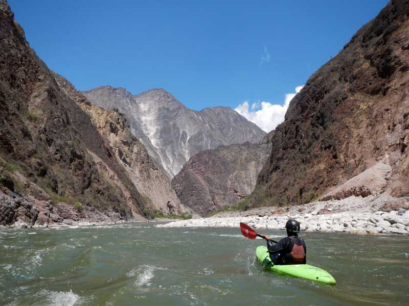
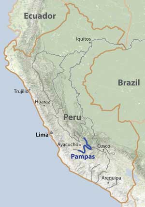
Río Pampas is the largest tributary of Río Apurimac, flowing through a deep arid canyon with at least 230 km of prime raftable class IV river. The river is one of the nicest to paddle in the Andes with beautiful clean river flowing through an arid canyon with big beaches and a lot to explore. One noteworthy stop for our group will be to hike up and explore the Incan ruins of Vilcashuamán. This expedition is being run to document the river canyon features and provide reasons to oppose several planned dams. The trip down the Pampas likely provides a comparable experience to the Grand Canyon Amazon.
Several planned dams on the Pampas-Apurimac would destroy this amazing natural resource as well as the recreational opportunity it affords. You can see more about the dams on the SAVE RIO MARANON! webpage, in the PLOS1 article, and at this VIDEO. With our documentation of the river, there will be more reason to oppose the dams.
This trip is open to everyone: rafters, kayakers, IKers, and passengers. If you plan to paddle your own boat, you must be very comfortable in class IV water. Our journey will start in Cangallo (3 hr drive south of Ayacucho) at 2600 m (8300 ft) elevation, a location you can view on Google Maps. After the raft portion of the trip ends, some expert kayakers in the group may continue another 4-5 days downstream to the jungle village of San Francisco/Kimbiri on Río Apurímac.
SPECIFICS OF THE RIVER:
The Pampas passes through an arid canyon that is often deeper than the Grand Canyon. Most of the river is enjoyable class II-III though several days feature challenging IV. Our raft trip will only cover the initial easier 230 km of the river (Main Pampas1 and Main Pampas2 below). There may be the opportunity for expert kayakers to continue in a self-support manner downstream through the Barranca Pampas and Lower Apurimac. Descriptions of each of the sections are provided below:
Vilcashuamán Pampas [km 0-143: 4.5 m/km (25 fpm): III]
The initial 143 km section starts in Cangallo and has a low gradient - frequent flat sections but studded with class III rapids and one canyon with several class IV passages. This is ideal as a warm-up section the first several days. There are large beaches and gravel bars nearly the entire way with steep canyon walls rising directly up from the riverbed. There are likely interesting side hikes, ruins, and hot springs to discover, enjoy, and document. The Incan ruins of Vilcashuamán are only 8 km hike from the river (though we might visit before the trip). The section ends at the Puente Pampas bridge crossing (road between Ayacucho-Andahuaylas). During the dry low water months of Jul-Sep, the flow is estimated to be ~30 cms (1000 cfs) to start but more than doubling by the end to ~70 cms (2400 cfs).
Main Pampas2 [km 143-230: 6.7 m/km (37 fpm); IV]
Shortly after passing Puente Pampas access point the gradient steepens significantly and many class IV rapids need to be naviagated. The toughest drop is here is the Catarata de Ocros. In 1979, the Nash rafting group reported the Catarata as a ~10 m vertical or near-vertical drop that was difficult to portage. In 1996, the Hughes kayak group did not report anything more than class IV in this section - which is the way the river remains to this day. After the Ocros section, the river continues with occasional class III-IV rapids for >50 km but still displays wide riverbed with expansive beaches and gravel bars abutting steep canyon walls. The final part of the section enters a remarkable narrow canyon.
Barranca Pampas [km230-282: 8.1 m/km (45 fpm): IV+ (oneP)]
The final 50 km section of Río Pampas passes through an impressive gorge [the "Barranca Pampas"] before joining the Apurimac at the end of the Apurimac's "Abyss". While the Apurimac's Abyss is a serious class V run with high gradient [often 20-30 m/km (110-160 ft/mile)], Barranca Pampas has lower gradient [8 m/km (45 ft/mile)] and a slightly lower flow, so it is more manageable. A steep access road and footbridge is found ~10 km into the section (with the "90-curvas trail" up RL). The section ends at the confluence with Río Apurimac, which generally has 1.4X the flow of the Pampas. Tom Hughes wrote that section was "mostly class III, occasional IV and one simple portage about 6 kms above the Apurimac Confluence". They called the portage "Darth Vader", described as a place where "the river drops left into a sheer walled canyon for about 400 yards.... couldn't get down there to inspect so we portaged up a scree slope on the right to the canyon rim and [reentered the river] above a chunky class 4 we called Chewbacca." Darth Vader is actually 14 km upstream of the Apurimac confluence. A portage would be difficult, especially for rafts. However, in 2013 a huayco blocked the river just downstream of Vader at another rapid called Chewbacca and flooded Vader as well as other rapids upstream of it. Although the Vader gorge was easily navigable, the new Chewbacca rapid requires a portage (though this is much easier than portaging the Vader gorge). This section is best tackled by a kayak self-support crew.
Lower Apurimac [km282-450: 1.7 m/km (9 fpm): IV (oneP)]
The Lower Apurimac has been paddled several times, including by trip leader Rocky Contos in 2012. [photos in the slideshow above are from the Lower Apurimac, from scouts of the Pampas, and similar elevation upper sections on the Apurimac]. In the initial ~100 km of the Lower Apurimac, there are numerous class III and IV big-water rapids. Estimated flow in late May on the Lower Apurimac is 600 cms (21000 cfs) - a medium level. There is one easy portage of Powac, a class VI rapid located ~40 km downstream of the confluence (see picture above with the drying fish). After Powac, there are several tough IVs, and the dry desert-type cacti-studded terrain soon turns to lush jungle. The first village of Lechemayo-VillaVirgen is encountered 87 km after the Pampas confluence (369 km into the trip). We'll continue another 81 km through flat wide jungle river with occasional class II-III to the bridged towns of San Francisco-Kimbiri, with regular transportation service to Ayacucho (5hr) or Cusco (15hr). Depending on our progress, we may have some layover days. With two layover days and a full day portage of Vader, we would need to average 30 km/day when we are progressing downstream.
PRIOR DESCENTS:
1979: A rafting group attempted descent of the lower Pampas in 1979 starting at Puente Pampas, but they aborted in only a few kilometers downstream when their rafts wrapped on rocks in class IV rapids. They reported just downstream a major cataract/falls (La Catarata de Ocros). The group consisted of Rod Nash (leader), Cal Giddings, Ron Hayes, Dean Paschall, Rick Smith, Scott Hartman, and several others.
1996: A kayak self-support descent of the lower Pampas was completed in summer 1996 from Puente Pampas down to the Apurimac by Tom Hughes (USA), Benjamin Muniz (of Instinct Rafting, Cusco), Adam Jarco (USA), Hugh Pritchard (UK) and James Shrimpton (UK). Tom Hughes comments: "The entire trip took us 8 days to Villa Virgen from where we continued to San Fransisco (and onto Ayacucho by truck). As far as I know we were NOT the first to descend the river, it having seen at least one attempt before us (apparently the two man raft team walked out after running short of supplies although I don't know from what point)." The 1996 trip was written up and published in Playboating UK magazine.
| km | location | elevation | avg. flow Jul | gradient (to next) | difficulty | description of section (to next) |
| 0 | Cangallo | 2580 m | 40 cms (1200 cfs) | 4.5 m/km (25 fpm) | III | often flat; lots of II-III; some IV |
| 144 | Hwy Bridge | 1930 m | 80 cms (2400 cfs) | 6.7 m/km (37 fpm) | IV | starts IV(V?); lots of III-IV |
| 243 | 90 Curvas access | 1260 m | 90 cms (3000 cfs) | 8.1 m/km (45 fpm) | IV+ | main gorge; lots of IV; one P (Vader) |
| 282 | Apurimac confl. | 960 m | 200 cms (7000 cfs) | 3.0 m/km (16 fpm) | III-IV | big water III and IV; one P (Powac) |
| 369 | Lechemayo | 700 m | 230 cms (8000 cfs) | 1.5 m/km (8 fpm) | II-III | class II-III big water; good surfing |
| 450 | SF/Kimbiri | 580 m | 250 cms (9000 cfs) | - | - | class II to Río Mantaro |
TENTATIVE ITINERARY :
Day0: rendezvous in Ayacucho; meet group
Day1: drive to Vilcashuamán then Cangallo; rig and launch; ~5 km
Day2: class III; ~40 km;
Day3: layover day and visit to Vilcashuamán; 0 km
Day4: difficult section (~60 km downstream of put-in); class IV; ~30 km
Day5: relatively easy roadless canyon; two big tributaries boost flow; class III; ~40 km
Day6: pass Puente Pampas (km 144); enter Ocros section; class IV; ~30 km
Day7: navigate Ocros section; class IV+; ~30 km
Day8: class III-IV; ~40 km
Day9: arrive at "90 curvas" access point (km 243); continue into Pampas Abyss; ~30 km; class IV
Day10: difficult section at Vader and Chewbaca ; IV-V; ~25 km
Day11: finish difficult section; reach confluence with Apurimac (km 283); class IV-V; 15 km
Day12: layover day (if enough progress made); 0 km
Day13: Lower Apurimac; big water fun rapids; class III-IV; ~40 km
Day14: Lower Apurimac; big water fun rapids; class III-IV (one P); ~40 km
Day15: Lower Apurimac; enter jungle; arrrive Lechemayo/VillaVirgen (km 369); class III-IV; ~40 km
Day16: Lower Apurimac; arrive San Francisco/Kimbiri; class II; ~50 km; get ride to Ayacucho or Cusco
Visas/Permits:
Peru is a travel-friendly country that readily offers tourist permits for up to 90 days. Flights would be into Lima. You should be vaccinated against Yellow Fever, Typhoid, and Hepatitis A. You will be traveling into a malaria area as well so consider anti-malaria medication. Cusco is at high elevation [3400 m (11000 ft)] so if going there you may wish to have a prescription of acetazolamide.
Personality/Experience:
No river rafting experienced is required to join a trip. However, you should be comfortable camping and you should have an easygoing attitude in order to get along with a diverse group on a Grand Canyon-style trip for an extended period. If you are concerned about this issue, consider arranging a private trip (contact Rocky) or if you're an experienced group, contracting our outfitting services.
Everyone joining SierraRios trips should have an interest in river conservation and help us on our mission to document the river further, talk to residents, publicize the planned dams, and help train local guides. We welcome competent boaters. If you want to kayak, you must have adequate class IV experience and a solid roll. If you want to row a raft, you must have adequate experience rowing class IV rivers. Comparable rivers are the Colorado (Grand Canyon), Middle Fork Salmon, Thompson, Futaleufu, Karnali, Yangtze (Great Bend), and Zanskar. You should be in good physical condition. In general the pace is relaxed with several layover days, but there may be some long days on the water. You should plan to help facilitate the trip in any way possible, including transport of some gear down to Peru and to the river if necessary. You don't need to be bilingual but it is helpful and more fulfilling to communicate with local residents when we meet them.
Leadership/Decisions:
The policy we will take on the trip is that the trip leader will have main authority when it comes to decisions for the group regarding river progress, camp, etc. If a participant has overestimated their ability to row or kayak, he/she may be mandated to ride on a raft and or be assessed other penalties. Trip leader decisions can be vetoed by a majority vote of the group. Any participant always has the right to leave the trip if they so desire.
Maps:
Rocky already has all topo maps of the entire river. When you sign on to the trip, you will gain access to them so you can view and print out a copy for yourself. If you have the password, click here to access printable maps.
CLIMATE:
The trip occurs at tropical latitudes in the dry season but starting at relatively high elevation. Average annual precipitation is about 300-400 mm (13-16 in) along most of the Pampas. increases 2500 mm (80 in) by the take-out at San Francisco-Kimbiri. May-Oct is the dry season. The elevation at the put-in is 2600 m (8300 ft), so expect warmish days/cold evenings to start (25oC/77oF highs and 10oC/50oF lows). After the first few days, temperatures should be much warmer, with daytime highs ~30oC/86oF and lows of 10-18oC/50-64oF). A meterological station by Puente Pampas shows average temperatures are 30oC/12oC (86oF/54oF) from Jun-Sep. There is little chance of rain when the trip is run in the dry season. Expect rain if you venture down into the jungle area after the main rafting trip.
Expect daytime-biting midges (no-see-ums) in most camps, especially during the dry season when they are worst. Use DEET and/or lemon eucalyptus repellents to prevent bites, and bring light clothing to cover you legs and ankles. Mosquitos are not present at most camps but can come out at night in a few areas. They are much more common in the jungle. Other critters to beware of are spiders, scorpions, snakes, and giant centipedes.
RENDEZVOUS POINTS/TRANSPORTATION
AYACUCHO: The main rendezvous point will be Ayacucho. Ayacucho is a charming colonial city and a pleasure to stroll around on pedestrian cobblestone streets. Logistics will be coordinated before the trip. You will need to arrive to Ayacucho at least one day prior to departure for the river. You can get to Ayacucho from Lima easily on an 8-10 hr bus ride ($20-30USD). It is also possible to fly to Ayacucho from Lima (check domestic arilines like STAR, LAN, or PeruvianAir). Once we all meet in Ayacucho, we will take privately-contracted transportation to the put-in at Cangallo (3 hr drive south of Ayacucho). We may spend Day1 visiting the ruins at Vilcashuamán before arriving in Cangallo and rigging the rafts. Departing the trip midway is possible at kms 145. It is also possible to join the trip at this point. At the start or end of the trip, you might consider visiting Cusco and Machu Picchu, located ~14 hr from Ayacucho by bus.
CONTRIBUTION
This trip is being run to increase appreciation of the river and foment opposition to the planned dams. We welcome everyone: raft passengers, raft paddlers, raft rowers, kayakers, IKers, and guides. The pricing policy takes into account the costs associated with running the trip and the services offered. While typical rates are ~$4000 for a 14-day Grand Canyon trip or ~$2000 for a 6-day MF Salmon River trip, you can see that our rates for similar length trips where everything is taken care of are considerably lower: Contribution guidelines: General
We strongly encourage potential participants to offer the general contribution rate if possible. Special discounts are sometimes offered to folks on our email list, so you are encouraged to sign up (Email List info). Reduced rates may also be granted to certain participants with more limited financial means. This can be to raft guides, safety kayakers, and experienced oarsmen willing to work on the trip, to others who can help with publicity and/or fill the trip, and to anti-dam activists who will be instrumental in protecting the river. Please send an inquiry if you would like to be considered for a reduced rate, and keep in mind what basic Outfitting Services cost for a trip.
RESERVATIONS
If interested in joining a trip, start a discussion by sending a note stating how you found out about the trip and a little background info about you and your paddling experience, what dates might work for you, and what sections of the expedition you are most interested in joining. Once you get the go-ahead from Rocky, you will need to provide a deposit to reserve your place on the trip ($1000 for full trip). The balance must be received prior to trip commencement. See PAYMENTS for payment options.
TRIP LEADER AND TEAM MEMBERS:
(1) Rocky Contos descended the entire Marañon from its headwaters on Río Lauricocha to Iquitos from July to September 2012, and led three 20+ person 30-day expeditions in 2013 (Sep28) and 2014 (Jan16, Jun4, Oct14, and Dec4). He discovered the most distant source of the Amazon [see articles C&K, Outside, Nat.Geo, FoxNews, LaRepublica] and in 2012, also paddled all of Ríos Apurímac, Mantaro, and Urubamba as part of his Headwaters of the Amazon expedition. He has explored nearly every river in Mexico including >100 first descents covering ~8,000 km of river and ~55,000 m of drop, as well as most in Peru. Rocky believes the Marañon is one of the finest Grand Canyon-style raftable rivers in the South America. He is fluent in Spanish and has organized many Grand Canyon length trips. Several articles have featured Rocky (American Whitewater; Kayak Session; Canoe & Kayak). While attaining his Ph.D. in neuroscience (see CV), Rocky worked as a kayak instructor and guide for UCSD's Outback Adventures from 1993-1996 and gained valuable trip planning skills for large groups. Although primarily a kayaker, Rocky started rafting in the mid-1990s in order to introduce more people to the wonders of river travel. He has organized numerous large group raft and kayak expeditions through the Grand Canyon (7X), MF+Main Salmon River (4X), Río Mulatos-Aros (4X), Río Usumacinta (8X), Taseko-Chilcotin-Fraser (1X), and many other long trips to the Salt, Kern, Rogue, Deschutes, John Day, Thompson, Similkameen, and Baja California. Rocky founded SierraRios with the goal of conserving the rivers of Latin America, and hopes that increased awareness and enjoyment of the resource will lead to protection. He is organizing most aspects of the trips and will lead some but cannot lead all.
(2) Pedro Peña will be likely be co-guide. Pedro was born in Lunahuana near Lima and started kayaking and rafting at a young age on the Lunahuana. He has been a raft guide for most of this life on the Cañete, Apurímac, and Futaleufu. He rafted the Lower GC Amazon several times for dam survey crews but would not do so now for a love of the free-flowing river. He signed the PETITION and is working to help stop the dams.
SAFETY / HEALTH
(click here)
FOOD/ALCOHOL/WATER
(click here)
CHORES, TOILET AND BATHING
(click here)
WHAT TO PACK
(click here)
BOATS AVAILABLE FOR THIS TRIP
(click here)
.A FEW COMMENTS FROM PAST PARTICIPANTS:
"I need to do another expedition!!!!! I'm already jonsing for one .... The Marañon trip was one of kind that I will never forget ... the perfect combination of big water, gorgeous scenery and a taste of rurual Peruvian lifestyle! ... I would do this trip again in a heart beat ... It really is amazing how helpful some people have been along the way. Going way out of their way in order to help..."
Amie Begg; class IV kayaker on 2012 Marañon trip
"The Marañon trip was a magical journey. Big, clean water; big canyons and expansive natural beauty; and big-hearted, friendly people who made us feel welcome along the way, while sharing with us their fears of imminent dams, mines, and petroleum drilling. I hope we can find a way to help them protect this incredible treasure and their ways of life."
Barbara Conboy; SierraRios board member and rafter/kayaker on 2012 Marañon trip
"THE TRIP KICKED MAJOR ASS! mike" [2011 Mulatos-Aros trip; 2012 Marañon trip]
Mike Doktor (Portland, OR), former raft guide for Ken Warren Expeditions
"Hi Rocky, Thanks again for a sensational and unforgettable trip. You did such an amazing job organizing. I especially am psyched to have met you and to have another kayak friend/guide to work with. You guiding me off the waterfall was a big highlight... Erik." [2011b Usumacinta trip]
Erik Weihenmayer, blind mountaineer/author and budding kayaker (see www.TouchTheTop.com )