|
RÍO PIAXTLA: Deepest Canyon in Mexico |
|
183 km (108 miles), class III (some optional IV), 8 days |
| Aug-Sep: rendezvous in Mazatlán . RESERVE NOW |
Join an expedition on Río Piaxtla as we charter a flight up into the deepest canyon in Mexico near Tayoltita, and then paddle all the way to the Pacific Ocean on a relatively easy whitewater river. This is one of the last free-flowing rivers in Mexico's Sierra Madre Occidental - no dams at all, and with a good channelized current to the Pacific Ocean. We welcome everyone: kayakers, IKers, and raft passengers. VERSIÓN ESPAÑOL
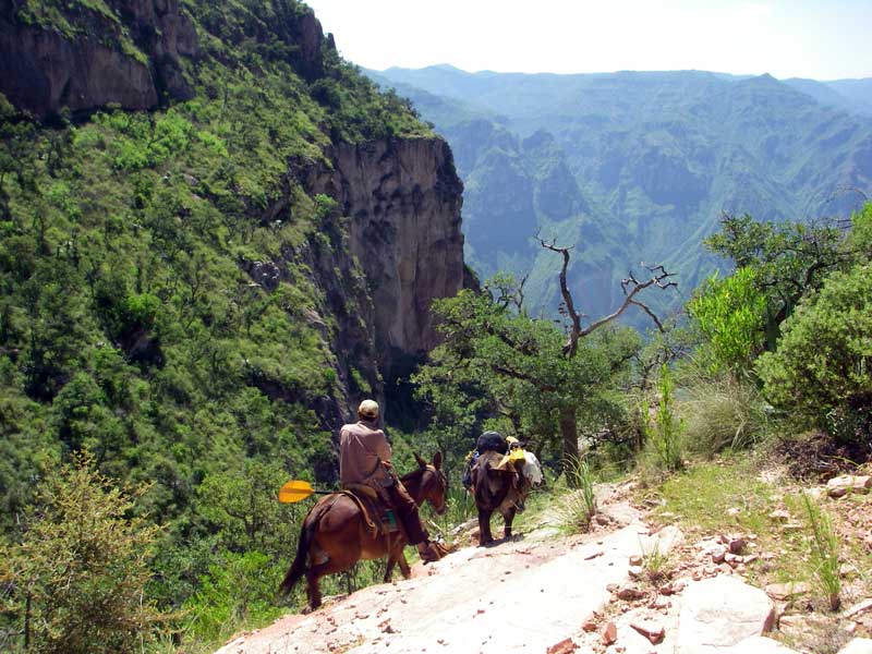
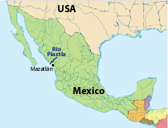
Río Piaxtla flows through the deepest canyon in Mexico [over 2400 m (8000 ft) deep on either side] and is one of the few remaining undammed rivers of the Sierra Madre Occidental. As such, it is a very special river journey to experience. After flying into Tayotita, we'll set up a base camp at the upper road's end and take a full day to hike up and explore the deepest canyon section a little more, paddling back to camp. We'll then embark on our long 183 km journey to the sea. All are welcomed: kayakers, rafters, and raft passengers/paddlers – bring your own boat or use one of ours. This trip is particularly suited to intermediate and novice kayakers, who can ride in the paddle raft through the tougher class III-IV upper sections and then enjoy kayaking several days of mostly class II water as we make our way to the ocean.
TENTATIVE ITINERARY:
Day 0: rendezvous with participants in Mazatlán; dinner; HOTEL
DAY 1: fly or drive to Tayoltita (1 hr drive+1 hr flight); restaurant dinner; unload gear at base camp; km 0
DAY 2: Hike up to deepest canyon point; float back in packrafts/IKs/kayaks; class III-IV; up to 20 km
DAY 3: Finish rigging and start downstream journey; pass Tayoltita; class III-IV; ~20 km
DAY 4: Main Piaxtla canyon; class II-III; ~30 km
DAY 5: Main Piaxtla canyon; pass confluence with Río Verde; class II-III; ~40 km
DAY 6: Lower; stop for lunch in San Ignacio; camp downstream; class II; ~40 km
DAY 7: Lower; class II; play waves; diversion dam; end at mouth; camp by mouth on ocean beach; ~40 km
DAY 8: play in surf; de-rig; drive back to Mazatlán; end; final dinner; HOTEL
COST
This trip is being run to increase appreciation of the river and foment opposition to the planned dams. We welcome everyone: raft passengers, raft paddlers, raft rowers, kayakers, IKers, and guides. No prior rafting experience is required to join a trip. We offer professional level service similar to other established outfitters. The general costs of this and other trips is listed at: COSTS
Special discounts are sometimes offered to folks on our email list, so you are encouraged to sign up (Email List info).
RESERVATIONS
If interested in joining a trip, start a discussion by sending a note stating how you found out about the trip and a little background info about you and your paddling experience, what dates might work for you, and what sections of the expedition you are most interested in joining. Once you get the go-ahead, you will need to provide a deposit to reserve your place on the trip. The balance must be received prior to trip commencement. See PAYMENTS for payment options.
TRANSPORTATION
We will have a vehicle to pick you up in Mazatlán and transport you to the river and back. Depending on the number of paying participants, this vehicle might be a large pickup (5-person capacity), Suburban (7- or 9-person capacity), or combination of the two. We plan to charter a flight from San Ignacio up to Tayoltita or a point on the rim and make our way back to San Ignacio and then all the way to the ocean. The planes can handle 6 passengers each.
SAFETY / HEALTH
(click here)
FOOD/ALCOHOL/WATER
(click here)
CHORES, TOILET AND BATHING
(click here)
WHAT TO PACK
(click here)
SAFETY
The violence in Mexico surrounding the drug was has been in the news a lot in the past three years. The violence is confined to drug traffickers (narcos) and those associated with them, including law enforcement. In addition, the river we will be journeying down did not have any marijuana cultivation visible near it, and we are likely to encounter few residents. Locals from Sahuaripa will accompany us to the put-in and from the take-out, facilitating positive interactions. We may even have one such person in guide training on the raft. As such, we are not likely to be harassed or molested in any way related to the drug war. For further discussion of the drug war and safety concerns, click here.
Independent of the drug war, there has always been potential danger for assault in Mexico by armed bandits (bandidos). This is not different now as it was 5 years ago or 10 years ago or 20 years ago. Such risk is common in any third world country where citizens are very poor. In the event of assault, we will do all we can to protect our clients and ourselves, but may have to sacrifice our possessions. Since we can never guarantee against such assault, you must agree not to hold us liable for consequent personal injury/damage/loss you sustain on this outing.
The other aspect of safety is prevention of accidents. It is of utmost importance that you take all precautions necessary to avert injury, sickness, and complications while on the trip. As guides, we are there to help get you safely to the river, down it, and back out, but cannot guarantee against accidents. You must accept the responsibility for what happens on the river if you are in control of your craft. If you are concerned about the whitewater or other aspects, it is your responsibility to make appropriate decisions whether to run the rapid or not and to stay close to someone who can watch and oversee you (if you desire that level of protection). If an accident occurs, we will do all in our power to help you, see that proper care is rendered, or evacuate you if need be. Rocky was trained as a Wilderness First Responder and can administer appropriate emergency medical care if needed. We will have two basic first aid kits available. We will also carry a satellite phone for emergencies and changes of plan.
WATER LEVELS
We have timed this trip to coincide with highest probability of encountering good river flows in the Piaxtla. In Aug-Sep, flows average ~40 cms (1500 cfs) at Tayoltita. It is very likely (~80% chance) that we will have 10-120 cms (350-4000 cfs) during our trip, but there are slim chances it will be higher (10%) or lower (10%). Water levels can fluctuate rapidly due to spotty intense thunderstorms that are characteristic of the monsoon season in the region. At low water the river may not seem as difficult. At high water, the water moves faster and big hydraulics develop. It is important that rafts be tied up well so they don’t drift away in a rising tide on the river. Equally important, the camp must be set at a high enough location so it will not be flooded. We may encounter rapidly rising river that reaches camp (usually in the evening). If this happens and you are the first to notice, please wake the guides first, and we will assess the situation. It may be necessary to move camp higher.