|
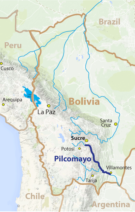
RÍO PILCOMAYO: Grand Canyon of the Pilcomayo |
|
450 km (280 miles), class IV, 14 days |
| launches: Feb14 (2024) RESERVE |
| OTHER TRIPS |
Río Pilcomayo is the main Andean headwater stream of Río de la Plata with its origins high on the altiplano of Bolivia. On this Grand Canyon-style trip, we'll navigate class III-IV rapids with rafts and kayaks as we progress down the silty desert-like river into the jungle . On the way, we'll camp on beautiful clean beaches, hike up slot side canyons, admire parrots, toucans, and capybara, and in general explore this wilderness area more. You might also consider joining a trip on the similarly large Río Grande in Bolivia as well.
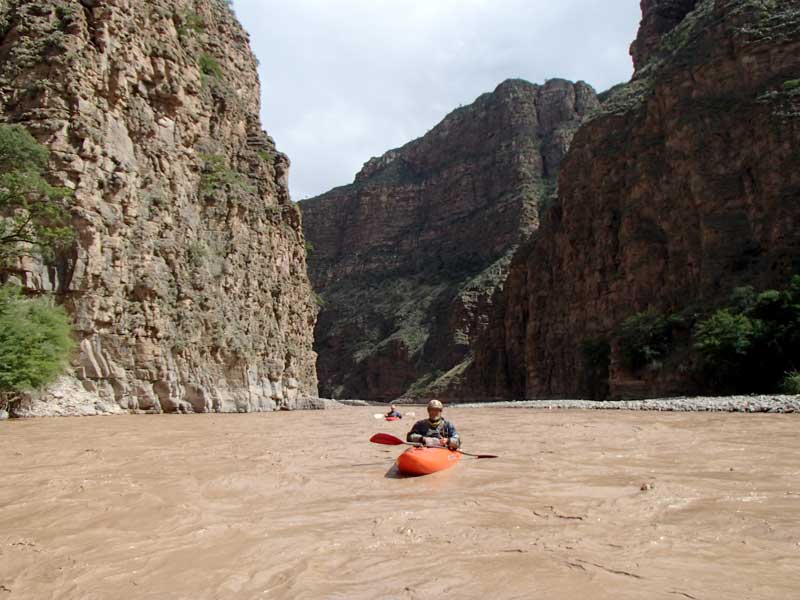
Río Pilcomayo offers one of the few scenic, fun, beautiful, interesting and challenging high quality Grand Canyon-style trips in the world (see Slideshow). On these expeditions, we will base out of the charming colonial city of Sucre then head down to the river at the old castle-like Puente Sucre bridge where we'll rig. Once on the water, we'll move quickly on the silt-laden water through the canyon downstream, passing through desert-like canyons reminiscent of the Southwestern USA, but then get into savannah and jungle sections. Most days will be class III, but at least three days have significant class IV rapids as well. Trips will be run like the similarly long journeys on the Grand Canyon of the Amazon (Río Marañón) in Peru. In some years the Pilcomyao might have little water, in which case we will descend Río Grande just north of Sucre - with similar length of river over the same amount of time.
Come join us for the first raft descents of these Grand Canyon style rivers in Bolivia and experience some of the last tropical wilderness areas that remain in the world. Help us in our mission to make the river and canyon known to increase visitation and provide more reasaons to keep the river free-flowing and undammed.
PILCOMAYO SECTIONS:
The Pilcomayo has several sections. The rafting trip will cover only the Gran Cañón and Yungas sections, though some kayakers can doa day run through the final part of the Slickrock section just before we launch with the rafts.
| section | km | days | class | note | |
| Altiplano | 80 | 3 | IV-V | uppermost floatable section, but much dewatered by a hydro diversion | |
| Slickrock | 130 | 5 | IV (P) | kayaks only; fantastic sandstone slot canyons; one long mandatory portage | |
| Gran Cañón | 320 | ~12 | IV | beautiful deep long canyon; mostly class II-III but some IV | |
| Yungas | 130 | ~3 | IV | jungle turning to savannah; mellower section but still tough pongos | |
====================================================================================
Slickrock
class IV (V/P)
130 km (81 miles) ; 5 days
Yocalla (3370 m) to Puente Sucre (2240 m)
8.7 m/km (48 ft/mile)
The Slickrock section of Río Pilcomayo starts near the fabled mining city of Potosí at Puente del Diablo by Yocalla and flows through several sandstone canyons and gorges reminiscent of the Glen Canyon-Escalante areas of the USA. As a small river with steeper rapids, narrow passages, and one long portage, this section of the Pilcomayo is only appropriate for kayakers. There are three incredible gorges to paddle through: Slickrock Narrows, Barranca Rosada, and Barranca Purunquilla. Kayakers joining the raft-support trip can spend the rigging day paddling through Barranca Purunquilla, naviaging some class IV-V rapids, and then enjoying the rest of the vertical-walled sandstone gorge in a more mellow manner. Near the end of this barranca is Quebrada Wilakola which offers a fantastic side hike where you can walk through a sandstone narrows that is in most respects a cave. The final ~30 km to Puente Sucre are easy river in more open canyon.
Gran Cañón
class IV
321 km (198 miles) ; ~10 days
Puente Sucre (2240 m) to Puente Aruma (630 m)
5.0 m/km (28 ft/mile)
The Gran Cañón section of Río Pilcomayo is a moderate gradient class III-IV section of river easily accessible from the town of Sucre. In this section, the river passes through a canyon that is 1000-2200 m deep on both sides the entire way. While the river goes by some villages in the first 100 km and has some access possible, overall this is very remote territory in the Bolivian Andes. Sandstone walls alternate with granite and limestone throughout its length. Highlights of the run are various constricted canyon sections where more challenging rapids are found and interesting slot canyons invite exploration. Beaches are huge and driftwood abundant. At high flows some of the rapids may be particularly dangerous as they continue on for a long distance. One rapid is usually portaged (Huaral).
Yungas
class IV
130 km (81 miles) ; ~4 days
Puente Aruma (630 m) to Villamontes (370 m)
2.0 m/km (11 ft/mile)
The Yungas section of Río Pilcomayo starts at the access point of Puente Aruma and continues for 130 km in jungle terrarin that gets a little less vegetated a bit farther down. Although there is plenty of easy water in here to relax and enjoy the wildlife, there also are sections with major rapids of class II, III and even some IV. Some of the toughest rapids are in the final gorge of the Andes, where several big water class IVs will be found, including the difficult final big finale rapid of Chorro Grande (IV-V). In the Chorro Grande area, the river has been a traditional fishing area for centuries, since the dorados, sabalos and other fish migrating upstream are often blocked by the major rapid and congregate just below it. The section ends at Villamontes just after the river exits the Andes. This is where SierraRios trips end and service ends.
====================================================================================
PRIOR DESCENTS::
The first full descent of Río Pilcmayo occurred Feb-Mar 2015 by Rocky Contos, Kurt Casey, and Greg Schwendinger in self-support kayaks. On this trip, the group experienced very high water starting at Puente Sucre. Rocky led a group with 4 rafts/catarafts and numerous kayaks on another descent Feb2016, and despite drought conditions with unusually low water, the group still made it through from Puente Sucre to Villamontes in the alotted 14 days. Prior to 2015, the flatter parts of the Yungas section had been descended at low water (by local residents), as well as the final Chorro Grande section by Villamontes (by various groups including Eric of EricAdventures).
Personality/Experience:
No river rafting experience is required to join a trip. However, you should be comfortable camping and in good physical condition, and also should have an easygoing attitude in order to get along with a diverse group on a Grand Canyon-style trip for an extended period. If you are concerned about the latter issue, consider arranging a private trip, or if you're an experienced group, contracting our Outfitting Services. You don't need to be bilingual but it is helpful and more fulfilling to communicate with local residents when we meet them. Every participant must sign a liability waiver.
Everyone joining SierraRios trips should have an interest in river conservation and help us on our mission to document the river further, talk to residents, publicize the planned dams, and help train local guides. We welcome competent boaters. If you want to kayak, you must have adequate class IV experience and a solid roll. If you want to row a raft, you must have adequate experience rowing class IV rivers. Comparable rivers are the Colorado (Grand Canyon), Middle Fork Salmon (high water), Thompson, Futaleufu, Karnali, or Sun Kosi. In general, the pace is relaxed with layover days planned, but there may be some long days on the water.
The policy we will take on the trip is that the trip leader will have main authority when it comes to decisions for the group regarding river progress, camp, etc. If a participant has overestimated their ability to row or kayak, he/she may be mandated to ride on a raft and/or be assessed other penalties. Trip leader decisions can be vetoed by a majority vote of the group. Any participant always has the right to leave the trip if they so desire, but no refund is due.
RENDEZVOUS POINTS/TRANSPORTATION
SUCRE: The main initial rendezvous point for our rafting group will be Sucre, a beautiful colonial city at 2800 m elevation that is the cultural and historic capital of Bolivia (formerly "Alto Peru"). It is relatively arid in this area but during the rainy season all plants are green. You might consider spending a little extra time in and around Sucre visiting various archaeological sites, dinosaur footprints/skeletons, pueblos, hot springs, and/or the mines of Potosí. We will provide transportation for the ~2 hr drive to the put-in from Sucre, as well as into take-out city of Villamontes.
Getting to Sucre: You should plan to arrive at Sucre 1-2 days before the launch date. International flights will generally land you in La Paz (LPB) or Santa Cruz de la Sierra (SRZ) [carriers include LAN, AmericanAir, United/Avianca, PeruvianAir (only from Peru)]. To get to Sucre from La Paz or Santa Cruz, it is best to fly (1-2 hr) since buses take a very long time (12-16 hr). Domestic Bolivian flights are operated by TAM, Amaszonas, and Boliviana (but there are others such as possibly TAB & Aerocon).
VILLAMONTES: The trip ends at Villamontes, which is located by Río Pilcomayo just after it exits the final pongos in the Andes. From Villamontes you can take buses either to Sucre (12 hr bus ride), Santa Cruz (7 hr bus ride), or Yacuiba (2 hr). All of these cities have flights to La Paz while Santa Cruz has international flights departing to the USA (American Airlines). If you head down to Yacuiba you can continue on buses into Argentina.
TENTATIVE ITINERARY (in the 14-day itinerary, the first two days are eliminated by starting at Puente Sucre):
Day0 SUCRE: pre-trip meeting 8 am Casa Solariega
Day1 truck to put-in 30 km upstream of Puente Sucre; rig; camp; km 245
Day2 hike or paddle to Quebrada Wilakola; finish rigging; km 245
Day3 Slickrock: pass Puente Sucre; to Barranca Carama; class II-III; km 283
Day4 GC: to Viña Quemada; class III; km 322
Day5 GC: past Orron Kota; class IV; km 355
Day6 CataractGorge start; class III; km 392
Day7 CataractGorge; past Huaranmayo; class IV-V; km 406
Day8 LAYOVER
Day9 CataractGorge end; class III; km 450
Day10 GC; to San Juan; class III; km 499
Day11 GC; past Narrows to Barranca Toucán; class III; km 513
Day12 GC; class II; km 560
Day13 Yungas; pass Puente Aruma (km 600); to Arenales bend; class II; km 612
Day14 Yungas; to Zanja; class III; km 660
Day15 Yungas; to Salvación; class III-IV; km 705
Day16 Yungas; Chorro Grande; class IV-V; END VILLAMONTES; km 727 [Hotel Villamontes]
Day17 return to Santa Cruz or truck up to Sucre; flights out of Santa Cruz possible this day
Expected Progress:
We will generally paddle from ~9 am to 4 pm with some stops for side hikes and at interesting locales. The current itinerary includes up to 4 layover days depending on our progress. The river is usually very fast during the rainy season so it is usually quite easy to cover 10 km/hr when we are on the water focusing on downstream progress. Stops for hikes, scouts, and water collection do cause signficant delays, but we should still easily cover the full distance in the allotted time. We may finish the trip a day early (no refunds). Class IV-V kayakers may have the option to run a tougher 45 km section through an incredible sandstone canyon on the rigging day.
Maps:
Members can access printable map guides of the river with appropriate pass codes. Topo maps span the entire river with roads, rapids, features and potential beach camps marked. If you would like access to these, you can sign up as a member of SierraRios specifying you're interest in Bolivia, and you'll receive immediate access to the mapss (book/DVD later). [also note links at top left column of this page and at TOPO MAPS on the main www.SierraRios.org homepage.]
CLIMATE AND BUGS:
The trip occurs at tropical latitudes starting in relatively arid country at moderate elevation and ending at lower elevation jungle. Average temperatures at two representative locations along the trip are presented below. We can expect some cloudy days and rain at times, but in general it will be hot in the day and warm to cool at night. On most of the river the water is warm (20-23oC) so usually not even a paddle jacket is necessary, but is recommended in case it gets stormy and cool.
CLIMATE: The climate averages for Sucre (2800 m elevation), Tarija (1850 m elevation) and Santa Cruz de la Sierra (450 m elevation) are shown below.
| Sucre (2810m) | Jan | Feb | Mar | Apr | May | Jun | Jul | Aug | Sep | Oct | Nov | Dec | Avg |
| AvgHigh(oF) | 72 | 71 | 72 | 72 | 72 | 71 | 73 | 75 | 76 | 76 | 76 | 74 | 73 |
| AvgLow(F) | 52 | 51 | 50 | 48 | 45 | 41 | 40 | 43 | 47 | 50 | 51 | 51 | 47 |
| AvgPrecip(in) | 5.0 | 3.5 | 2.4 | 1.0 | 0.1 | 0.0 | 0.1 | 0.1 | 0.6 | 0.8 | 1.9 | 3.8 | 26 |
| Tarija (1850m) | Jan | Feb | Mar | Apr | May | Jun | Jul | Aug | Sep | Oct | Nov | Dec | Avg |
| AvgHigh(F) | 82 | 86 | 84 | 83 | 82 | 80 | 78 | 81 | 82 | 83 | 81 | 81 | 82 |
| AvgLow(F) | 58 | 62 | 57 | 55 | 50 | 46 | 46 | 49 | 53 | 55 | 57 | 57 | 54 |
| AvgPrecip(in) | 5.0 | 3.5 | 2.4 | 1.0 | 0.1 | 0.0 | 0.1 | 0.1 | 0.6 | 0.8 | 1.9 | 3.8 | 19.3 |
| SantaCruz(450m) | Jan | Feb | Mar | Apr | May | Jun | Jul | Aug | Sep | Oct | Nov | Dec | Avg |
| AvgHigh(F) | 86 | 86 | 86 | 82 | 79 | 75 | 75 | 81 | 84 | 86 | 86 | 86 | 81 |
| AvgLow(F) | 72 | 72 | 72 | 68 | 64 | 61 | 61 | 64 | 66 | 70 | 72 | 72 | 66 |
| AvgPrecip(mm/in) | 4.5 | 4.2 | 3.5 | 2.5 | 2.6 | 1.9 | 1.5 | 1.0 | 1.8 | 3.2 | 3.9 | 5.5 | 36 |
BUGS / UV / SILT: UV rays from the sun are intense so it is recommended that you use sunblock liberally. This trip has surprisingly few biting gnats and almost no mosquitos. But to avoid bites, use repellent or wear light clothes that cover your body. Other critters to beware of are spiders, scorpions, snakes, and centipedes. Also, the river water is extremely silty, so you should be comfortable with being "dirty" on much of the trip. We will have fresh water to rinse off a bit at camps, and all drinking water will be collected at clear side streams.
COST
This trip is being run because it is one of the most incredible in the world and more paddler visitation is needed to help raise awareness. More ecotourism income to the region and appreciation of the natural resource will help stop the river's destruction with dams. Our pricing guidelines are found at the following link: Contribution guidelines: General
Special discounts are sometimes offered to folks on our email list, so you are encouraged to sign up (Email List info).
RESERVATIONS
You will need to provide a deposit to reserve your place on the trip ($500). Please email a note about you and your intent to join the trip to reservations@sierrarios.org. Full contribution must be received at least 2 weeks before the trip. See PAYMENTS for payment options and cancellation policy. Trips may be cancelled 3 months before launch if there is not enough interest (6-8 paying participants will assure a trip occurs).
TRIP LEADER AND TEAM MEMBERS:
(1) Rocky Contos (scheduled trip leader), kayaked the first descent of Río Pilcomayo in 2015, and has also kayaked most rivers in Peru and Mexico. In Peru this includes Ríos Cotahuasi, Colca, Cañete, as well as all of the upper Amazon headwater streams (Mantaro, Apurímac, Urubamba, and Marañon) as part of his Headwaters of the Amazon expedition. He discovered the most distant source of the Amazon [see articles C&K, Outside, Nat.Geo, FoxNews, LaRepublica]. He has explored nearly every river in Mexico including >100 first descents covering ~8,000 km of river and ~55,000 m of drop. Rocky is fluent in Spanish and has organized and guided many Grand Canyon length trips. Several articles have featured Rocky (American Whitewater; Kayak Session; Canoe & Kayak). While attaining his Ph.D. in neuroscience (see CV), Rocky worked as a kayak instructor and guide for UCSD's Outback adventures from 1993-1996 and gained valuable trip planning skills for large groups. Although primarily a kayaker, Rocky started rafting in the mid-1990s in order to introduce more people to the wonders of river travel. Since then and throughout his years as a postdoctoral research associate, he organized and led numerous large group raft and kayak expeditions, including five through Grand Canyon (18-22 days), three on the Salmon River (4-10 days each), two on Río Mulatos-Aros (8-11 days), eight on Río Usumacinta (7-8 days each), eight on Río Marañon (14-30 days each), dozens to destinations such as the Salt, Kern, Rogue, Deschutes, John Day, Thompson, Similkameen, and Baja California (2-6 days each). Rocky founded SierraRios with the goal of conserving the rivers of Latin America, and hopes that increased awareness and enjoyment of the resource will lead to protection. He is organizing all aspects of the trip. He likely will be kayaking but may row a raft.
(2) Pedro Peña, Ariel Diaz and a set of safety kayakers will round out the guides on this trip.
(3) All oarsmen will be experienced river runners and raft captains guides with extensive experience. Non-experienced and less-experienced participants are welcome to join as raft paddlers/passengers.
FOOD/ALCOHOL/WATER
(click here)
CHORES, TOILET AND BATHING
(click here)
WHAT TO PACK
(click here)
SAFETY/HEALTH
A major aspect of safety on this trip is prevention of sickness and accidents. It is of utmost importance that you take all precautions necessary to avert sickness and complications while on the trip. For example, it is a good idea to be vaccinated against Hepatitis A, Typhoid, and Tetanus [however, no vaccines are required].
All participants must assume responsibility for themselves and sign a liability waiver before the trip. We cannot guarantee against accidents. If you're an inexperienced boater, the trip leader and guides will advise you on saftey issues. If you are an experienced boater in control of your craft, you must accept the responsibility for what happens to you on the river. It is the experienced boater's responsibility to make appropriate decisions whether to run the rapid or not and to stay close to someone who can watch and oversee you. A certain level of freedom will be provided, but each such person must abide by trip leader requests, which may mandate not paddling certain rapids. If an accident occurs, we will do all in our power to help you, see that proper care is rendered, or evacuate you if need be.
We will have an Inmarsat satellite phone ($1.50/min for calls) and possibly a SPOT device. Anyone can see the latest SPOT position of the SierraRios trip if we utilize it.
Río Pilcomayo is mostly rain-fed and generally runnable in the rainy season starting late Dec through late Apr each year. Flows can fluctuate greatly during this time of year, so you might have as little as 1/4 of the average flow and as much as 8X the average flow, but usually the flow will be between 50% and 200% of the average. Thus you have to expect variability as to what you might encounter, and on an expedition lasting two weeks, you're likely to experience a range of flows.
| river | Ene | Feb | Mar | Abr | May | Jun | Jul | Ago | Sep | Oct | Nov | Dic | - | Avg | |
| Pilcomayo (P.Sucre) - est. | cms | 120 | 150 | 120 | 60 | 30 | 20 | 15 | 13 | 11 | 10 | 10 | 50 | - | 60 |
| cfs | 4000 | 5000 | 4000 | 2000 | 1000 | 700 | 500 | 440 | 380 | 350 | 350 | 1700 | - | 2000 | |
| ---------------------------- | ----- | -------- | -------- | -------- | -------- | -------- | -------- | -------- | -------- | -------- | -------- | -------- | -------- | - | -------- |
| Pilcomayo (Villamontes) | cms | 500 | 600 | 500 | 200 | 100 | 60 | 40 | 30 | 25 | 20 | 25 | 200 | - | 200 |
| cfs | 18000 | 21000 | 18000 | 7000 | 3500 | 2000 | 1400 | 1000 | 1300 | 1200 | 1300 | 7000 | - | 7000 |
BOATS AVAILABLE IN BOLIVIA:
[current list available in Bolivia]
A FEW COMMENTS FROM PAST PARTICIPANTS:
"The Marañón resembles the Grand Canyon of Colorado in many ways with its rapids, beaches, side canyons and deep cacti-studded gorges. Both rivers offer numerous side-hikes and waterfalls. Like the Canyon, the Maranon is ideal for a long multi-day boat trip where a person can forget the grind of everyday life... However, the Maranon offers much more. Unlike the Grand Canyon, the Maranon is free flowing and its character can change overnight by the whims of nature. Its navigable section is much longer than that of Colorado and its canyon is deeper. Some Maranon beaches are big enough to accommodate small villages. The Maranon offers more and greater variety of rapids that are overall more challenging to navigate. Its continuously strong current makes it possible to easily cover 30-40 miles per day in a raft, assuming one does not stop for side hikes. The jungle area of the lower Maranon has no equivalent on the Colorado... I cannot think of another river in the lower 48 States that offers the same kind of experience."
Boris Trgovcich, class IV rafter/IKer and former raft tour operator in N.California. [2013Sep Marañon trip participant]
See Full Comment
"I found the river trip labeled the "Grand Canyon of the Amazon" to be completely comparable to the Grand Canyon of the Colorado in most respects, and it exceeded my expectations in every way... In the 1980s I paddled the Bio-Bio as a participant on one of the first commercial kayak trips in Chile [with] Chris Spelius. While [the Bio Bio's] destruction was abominable both environmentally and culturally, the size and importance of the Bio-Bio's destruction was but a small warning shot compared to the potential disaster planned for the Marañón/Amazon."
Kelly Kellstadt, class III-IV kayaker and former guide/instructor in New Mexico. [2013Sep Marañon trip participant]
See Full Comment
"I need to do another expedition!!!!! I'm already jonsing for one .... The Marañon trip was one of kind that I will never forget ... the perfect combination of big water, gorgeous scenery and a taste of rurual Peruvian lifestyle! ... I would do this trip again in a heart beat ... It really is amazing how helpful some people have been along the way. Going way out of their way in order to help..."
Amie Begg; class IV kayaker on 2012 Marañon trip
"The Marañon trip was a magical journey. Big, clean water; big canyons and expansive natural beauty; and big-hearted, friendly people who made us feel welcome along the way, while sharing with us their fears of imminent dams, mines, and petroleum drilling. I hope we can find a way to help them protect this incredible treasure and their ways of life."
Barbara Conboy; SierraRios board member and rafter/kayaker on 2012 Marañon trip