Information for reviewers: click on the following to access relevant files for the manuscript submitted to AREA: Correct Placement of the Source of the Amazon River in the Mantaro River Drainage:
Much of the analysis was done on projected shapefiles in the ArcMap program from ESRI (ArcGIS). Click on the link above to open a folder with the various files for traces along the river using:
HydroSHEDs ("HydroSHEDS")
VMAP1 ("VMAP1_wtrcrsl_v1")
DigitalPeru ("DigiPeru_hidro2_dp")
Topographic Map ("TopoMap_Traces")
Google Earth traces ("GE_Traces")
GPS ("GPS_Project_RAW" and "GPS_Project_CORRECTED")
Most or all files should be shapefiles. When imported by "Add Data" into the ArcMap program, select the shapefiles and right click to "Open Attribute Table". This will show the measured length of each line segment. Relevant river trace line segments are listed under one of the columns ("Explore", "Name").
Click on the link above to view a folder with:
(1) Topographic map traces layer from ArcMap. This can be downloaded and then imported into ArcMap. To view the topographic maps the traces were drawn on, in ArcMap go to "Add Data" and search for INGEMMET. You should be able to find and select "Carta Topografica" as a baselayer. With the topographic map traces, the measured distances of each segment can be viewed in the Attributes Table.
(2) Topographic map jpg files that were imported into Adobe Illustrator and had lines with kilometer marks drawn over the streams. You should be able to view small JPG files of 16"X20" sections of the map showing the km marks along the river either in a browser or after downloading and opening with an application like Preview, Picture Viewer, or Photoshop. The km marks were calibrated to the scale bars and grid on each map - on many of the maps you can see the calibrated km marks on straight vertical and horizontal lines.
.KML FILES OF RIVER TRACES AND GPS TRACKS
Click on the link above to open a folder with the files, which you can download. These can be viewed by dragging them into Google Earth, or by opening them in the Google Earth program: select "FILE", then "OPEN". In the "My Places" area, the traces will appear. There are corrected and uncorrected GPS tracks, as well as traces based on Google Earth satellite images. If you right click on one of the kml files one loaded, you will get an option to select "Get Info" and then "Properties", you will see the measured distance of the point-to-point mapping path. If you select "Elevation Profile" you can click on a part of the path and be taken to it. Note the "Elevation Profile" km marks sometimes have an error (shorter) compared to the actual distance measured in "Get Info"/"Properties" due to projection errors.
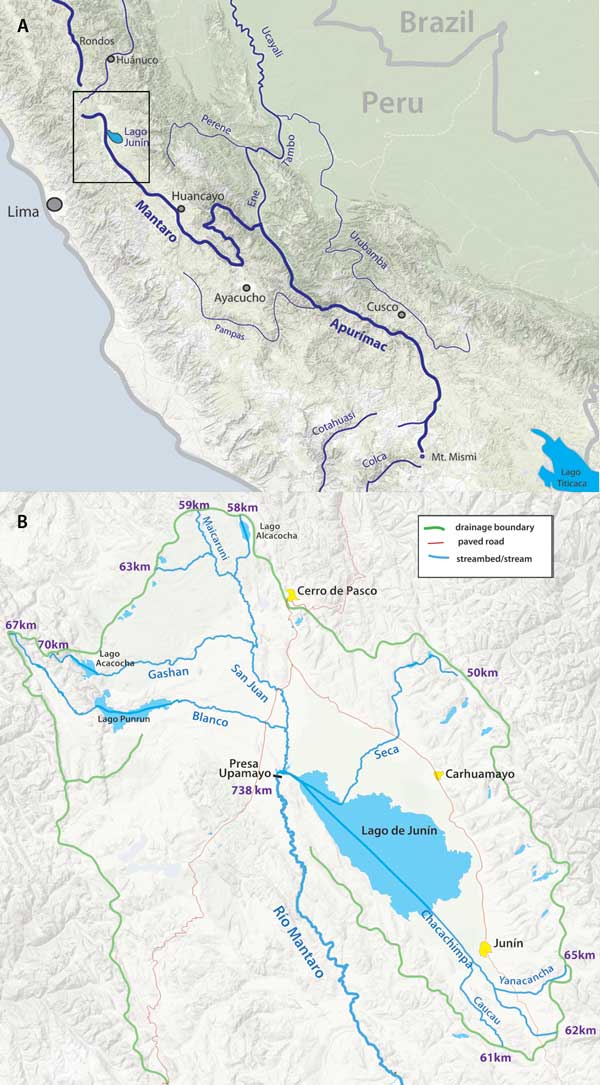
Fig. 1. (A) Map showing the uppermost branches of the Amazon River, including the currently held source stream of Río Apurímac (731 km), along with Río Mantaro, the longer stream (808 km). (B) Map of the headwaters area of Río Mantaro, including measurements according to topographic maps from the most distant point in various feeder stream drainages down to Presa Upamayo.