| OTHER TRIPS |
|
Chilko-Fraser: Glacial lake to hot desert with tons of salmon! |
|
522 km (~313 miles), class IV (half-trip possible) |
| launches: TBD [private group outfitting only] RESERVE |
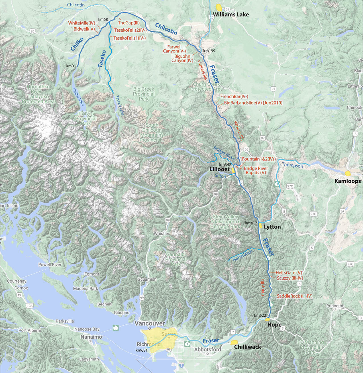
The Chilko-Chilcotin-Fraser river trip in British Columbia offers the best river journey in Canada, passing through beautiful varied montane then desert canyon with challenging class III and IV rapids as we float over the largest salmon run in Canada. On this trip, you'll cover the ~70 km of the Chilko from its lake outlet through many rapids including Bidwell and WhiteMile, then continue 130 km on the Chilcotin through Farwell Canyon to the Fraser. where you'll progress 326 km on this massive river through many rapids including the Big Bar, Bridge River and Hell's Gate. See the salmon run, meet First Nations people, and enjoy the hot desert canyon with loads of fun rapids.

The Chilko-Fraser river trip offers a wonderful journey with a huge variety and quantity of rapids of class III and IV difficulty, a huge salmon run each season, and several notorious major rapids on various sections of the trip: White Mile, Big Bar, Bridge River and Hell's Gate. Located in south central BC, this river trip will stat at the outlet of a long glacial lake with clear outflow and one of the largest salmon spawning stretches of river in the world. At 68 km downstream, the flow doubles where the Chilko and Taseko join and the river soon passes through the "Gap" where First Nations people are often fishing in summer. We then paddle down the Chilcotin with its Farwell and Big John Canyons (fun class III-IV rapids). At the Fraser (km 199), we enter a truly immense river that averages ~3100 cms (~110,000 cfs) in summer, with big wide class II and III rapids primarily but some class IVs and three rapids that can be even more challenging (Big Bar, Bridge River and Hell's Gate). The Fraser from the Chilcotin down to Lytton (km 412) is in a desert canyon with cacti, giant beaches, and First Nations still fishing in the traditional manner at Bridge River Rapid (and hot in the summer!). This trip is ideal for Cass IV paddlers/oarsmen who will find the river to be challenging and scenic, with pleasantly hot weather for Canada much of the way. We don't have the Columbia River with salmon going up the SF Salmon river anymore due to dams, but we do still have the full free-flowing Chilko-Fraser! Come get an idea of what a giant wild North American river is like. As on all our trips, we welcome kayakers, oarsmen, IKers as well as raft paddlers/passengers.
Currently we offer only Outfitting Service for experienced groups of boaters willing to take over responsibility for themselves on the water and do all camp chores (i.e., an unguided non-commercial trip). No commercial guided trips are being offered at this time.
EMAIL LIST: Sign up for our email list (send an email) and you'll be advised of upcoming trips and often special lower rates.
| MORE INFO: | |
| OVERVIEW MAP | |
| TOPO MAPS (of river) | |
| BoatsAvailable_Canada | |
RENDEZVOUS/LOGISTICS:
The main rendezvous point is Williams Lake, British Columbia (see Williams Lake), which is a town of ~20000 people with economy based on lumber. Wiliams Lake has hotels, restaurants and grocery stores, and importantly an airport with daily service to Vancouver. In general, we usually suggest guests arrive to the rendezvous city the day before the trip start with a pre-trip meeting dinner, stay in a hotel, and depart for the river the following morning.
ITINERARY:
Day0 Meet in Williams Lake; finish shopping/packing; pre-trip meeting dinner 7 pm; Hotel Williams Lake
Day1 Chilko Lake: ~4 hr drive to Chilko Lake (GoogleMaps); rig; see bears & salmon; camp; Chilko Lake camp (km 0)
Day2 Chilko: Pass out of the lake; over spawning salmon; first class II rapids; past Brittany Creek (30 L)
Day3 Chilko: Main rapids of the Chilko: LavaCanyon, Bidwell(IV), WhiteMile(IV), etc. Taseko confluence (68 L)
Day4 Chilcotin: The Gap (III). Relatively mellow Chilcotin; to near Lees Corner; near Lees Corner (125 R)
Day5 Chilcotin: Into more desert-like canyon; pass Big Creek; caves; camp near Farwell Canyon; Big Creek camp (167 R)
Day6 LAYOVER (this can also allow additional time if there are mishaps or the river is low and slow) (167 R)
Day7 Chilcotin: Farwell Canyon (III-IV)/hoodoos; former landslide dam; Big John Canyon (III-IV) Fraser confluence (199 L);
Day8 Fraser: Desert canyon : Alakali, McEwan, DogCreek; Churn Creek access; (240)
Day9 Fraser: French Bar Canyon; Big Bar Landslide rapid (IV): High Bar; Kelly Creek camp (301 L)
Day10 Fraser: big rapids: North Pavilion, Powerline, Upper+LowerFountain (IVs), Bridge River (V): Lilllooet (346 L)
Day11 Fraser: Bridge River paddle excursion; Seton River; MacGillivray Creek;; MacGillivray camp (375 L)
Day12 Fraser: Desert canyon; Lilllooet canyon section; class IIs;;to camp by Lytton; Lytton camp (412 L)
Day13 LAYOVER; possible day-trip on class IV Thompson River; Lytton camp (412 L)
Day14 Fraser: Lower Canyon; Siska Canyon (III); Keefer Canyon; Nahatlatch RR; Khamoose;; BostonBar camp (461 L)
Day15 Fraser Lower Canyon: Scuzzy; Hell’s Gate (V); Saddle Rock; to Hope; derig; hotel (522 L); (see GoogleMaps).
Note: Although the above is a typical itinerary for a 8-day Chilko-Chilcotin trip (plus another 7 days to complete the Fraser Canyon) -realize that progress downstream is dependent on the speed of the current, which is dependent on water level. Usually the Chilko and Chilcotin have maximal flows in July and August, but there is variability from year to year. It's often a good idea to have a layover planned to provide cushion for unexpected delays such as from mishaps, lower than anticipated water levels, or upstream wind. For trips continuing down the Fraser Canyon, realize that the river usually has its highest flows in June with steadily declining levels through summer. Thus progress downstream will generally be slower the later you are doing the trip in summer. [this can make a difference of 13-14 km/hr typical of high water to ~9 km/hr at low water often encountered in September]. Also realize that the Chilko access road is closed usually in September when there are a lot of bears around with all the spawning salmon, so groups launching later in the summer should plan on staring on the Taseko at Taseko Lake ( this makes the trip ~30 km longer but also has somewhat easier rapids on the Taseko compared to the Chilko).
RAPIDS :
The Chilko-Fraser trip has a lot of class III rapids, some class IV, and 2-3 class Vs (on the Fraser). The biggest rapids on the Chilko are called "Bidwell" and the "White Mile" both of which are long class IVs. There are other tough rapids on the Chilko, including Eagle's Claw, Lava Canyon and Maytag. Farwell Canyon and Big John Canyons on the Chilcotin have class III-IV water. On the Fraser, a new landslide on June23, 2019 near Big Bar created a new class V rapid (the "Big Bar rapid") - it was blown up in April 2021 to facilitate passage of salmon migrating upstream (they were dying because most couldn't make it up past the massive rapid that had formed due to the landslide), so this rapid is not necessarily class V anymore (probably class IV). Aside from many other rapids on the Fraser (mostly class II and III) there are several other major ones: Upper and Lower Fountain (IV), Bridge River (V) and Hell's Gate (V). Bridge River is a traditional fishing spot of the First Nations peoples around Lillooet, who congregate at the rapid in the summer to fish for chinook and sockeye. We will scout well and probably have some of our group walk around the class V rapids, and will ask for permission to pass from the tribe. Hell's Gate farther down has huge whirlpools and is another rapid that requires scouting and possibly some participants walking around. We will have AutoRights on the main rafts that will make safe passage possible..
ENTRY REQUIREMENTS & COVID RESTRICTIONS:
Canada welcomes tourists from the USA and Europe. General information on travel to Canada is available at the US State Dept_Canada. Citizens of the United States can enter Canada as a tourist for up to 180 days without any special visa. Generally, you are allowed to enter the country with personal clothes, a limited amount of alcoholic beverages, and one set of sporting goods for personal use (excess items may require payment of a duty). With regard to Covid-19, as of mid-2023, tourists entering Canada must still show proof of vaccination or a negative Covid test taken within 48 hr of entry. Those returning to the US do not need to have any specific test or show proof of vaccination (see USEmbassy_Canada.).
CANADA INFO (CURRENCY/ELECTRICITY/CELL PHONES)
The currency in Canada is the CAnadian Dollar (CAD), which has generally had a bit lower value than the US Dollar (USD) in the past 10 years. Currently the exchange rate is at ~1.34 CAD per $1 USD (Jun2023 - see CAD_exchange rate link for the current rate). Most establishments will take credit cards but it's a good idea to have some Canadian dollars for transactions. You can withdrawal some CAD at any ATM (there are plenty of ATM machines just like in the USA). Note that often exchange rates in airports are not as good as what you will get in the cities or ATMs. Any dollar bills you bring to exchange (or you provide to us) should be crisp bills free of any tears, writing or other defects. Electrical outlets are the same in Canada as the USA. Most cell phone carriers in the US have agreements with the carriers in Canada so you can use one of their networks without any extra fees (certainly true of T-Mobile and AT&T; probably Verizon as well). There is cell signal at various places along the route of the trip in the Chilcotin and along the Fraser (especially around Lillooet and Lytton, then downstream to Hope).
WEATHER/CLIMATE.
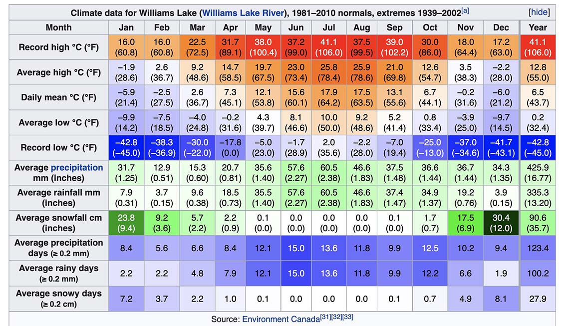
Although the start of the trip at Chilko Lake (or Taseko Lake) is pretty high elevation (~1100 m) with cool to cold nights, on most of the trip we'll have warm to hot days and cool nights in the main summer season (when we generally organize this trip). The average hi/low for Williams Lake (~550 m elevation), which is nearby and a similar elevation to much of the Chilcotin, is 26/10°C (78/50°F) in July and August, with about 60% percent possible sunshine these months. Farther downstream along the Fraser, the canyon near Lillooet and Lytton is known as the "hottest spot in Canada" , with temperatures even warmer than nearby Kamloops. In this section, the average temperatures in July and August are 30/14°C (86/58°F) - similar to the Columbia River Gorge and Yakima. The river temp gets its warmest in the summer as well (usually 14-18°C in July-August) , especially after the Thompson enters (due to most water in the river coming from the the warm surface water of Kamloops Lake).
FLORA , FAUNA & FISHING:
We’ll be floating through a montane forest on the Chilko or Taseko and then grasslands on the lower Chilcotin and Fraser. The plants along this river are interesting, and a flora guide will help you enjoy what you’re seeing (see BC Flora/Fauna Guide). However, one of the most interesting aspects of the Chilko trip is the fauna you will see, and particularly the salmon run making its way up the river. On average there have been ~1,200,000 sockeye salmon returning to Chilko Lake every summer (that averages to ~20,000 per day swimming into the lake in the main season (August). However, since 2012, the runs have been declining, to the point there have been few returns in 2019, 2020. In 2021 it was a bit better but seill only ~10% of normal. the 2022 seasonal return is expected to be closer to normal. [see PlightOfFraserSalmon]. There is also a large chinook salmon population that returns in summer, as well as a good number of coho and pink. If you’re into fishing, this is a great river to catch some salmon. However, you’ll need to abide by the BC regulations for fishing - the amount and times of year you can fish and keep sockeye and other salmon vary from year to year based on how many are returning and when. Aside from the bears and salmon, you may see some of the other fauna in the corridor, including wolf, coyote, otter, mink, wolverine, marten, beaver, muskrat and moose, as well as a variety of birds including bald eagle.
SAFETY:
Canada is considered one of the safest countries and is similar to the USA. No special precautions are necessary in this area or river to protect from the people nearby. There are bears along this river, so we also take measures to prevent them from getting into our food supplies (locking food in dryboxes and coolers in the evenings, and/or hanging it out of reach of bears, and possibly putting an electric fence around the kitchen). We will have some bear spray cans that can help deter any approaching bears. Please read BearSafety_BC_PP. The group will have a satellite communicator device for emergency communication and evacuation. With regard to whitewater, private groups contracting Outfitting Services to do the trip should be experienced enough to take care of themselves on the water. Captains of rafts should be experienced oarsmen who have rowed similar difficulty rivers (the Chilko is more difficult than the Rogue but similar to high-water MF Salmon and Selway; experience in the big water rapids of the Colorado's Grand Canyon is always good to have). To safely pass the big water class V rapids on the Fraser, it is a good idea to have some experience with AutoRights (such as on the Zambezi). The group should stop and scout all major rapids, and it is up to each raft captain, kayaker, and passenger to decide whether to proceed to run the rapid with the particular safety arrangement in place. If someone is not comfortable going through a particular rapid, generally there can be the option to walk around or hop on a raft to get through. With intermediate kayakers or those in IKs/packrafts in the water, there should be at least one expert kayaker along to help out with potential swimmers. Every participant doing the trip with Outfitting Service must sign a liability waiver..
MAPS.
You''ll get access to a set of annotated topographic maps of the river with rapids and other points of interest and will make these available to trip participants to download and print out. Click Topo Maps.
.COST
These trips are currently only being arranged for private groups of boaters contracitng Outfitting Service. Thee will be no paid guides on these trips and everyone joining the trip must help with rigging, camp chores, and derigging. Such groups take responsibiilty for getting themselves down the water safely and each participant must sign a liability waiver. Special discounts are sometimes offered to folks on our email list, so you are encouraged to sign up (Email List info).
Outfitting Service trip contribution includes:
transport: from Smithers to the river and back to Smithers after the trip
food on the river trip (starting from drive to put-in until return to rendezvous city)
boats: rafts, kayaks, inflatable kayaks, oars/paddles, all rigging
group camp gear: group kitchen, tables, toilet system, fire pan, fire blanket, rain tarp, etc
Trip contribution does not include:
personal paddling gear: (PFD, helmet, drybag, sprayskirt, paddle jacket): - available as RENTALS - indicate on INFO FORM
personal camping gear (tent, pad, sleeping bag): - available as RENTALS - indicate on INFO FORM
liquid beverage (beer, wine, Coke, Sprite, etc): we can bring up to 5 cans/day/person - indicate on the INFO FORM
hotels: unless otherwise noted (we can usually arrange)
restaurant meals: unless otherwise noted t
airport transfers or flights: we can arrange airport transfers
additional excursions before/after trip - such as a day-trips
RESERVATIONS
If interested in arranging a trip (or joining a group), send a note stating how you found out about the trip and a little background info about you, your group, your paddling experience, if you're willing to have others possibly join your group (or if you want to join a group already formed or forming) and what dates might work for you. Once you get the go-ahead, you will need to provide a deposit to reserve your place on the trip. The balance must be received prior to trip commencement. See PAYMENTS for payment options.
Outfitting Service can be arranged for groups of any size, but certain fixed costs of all trips lead to the cost per person increasing for smaller groups. Any dates listed above are dates of other private groups already planned who may be willing to accept additional partiicpants.
CANCELLATIONS:
We reserve the right to cancel the trip 2+ months in advance. If we cancel the trip, all deposits and payments will be refunded.
If you must cancel, you'll only get your deposit back if you find someone to take your place on the trip. If you don't find someone, don't expect any refund. (though credit toward a future trip is sometimes allowed). It is best to seek reimbursement from a travel insurance policy that we strongly recommend you obtain. You can find these insurance policies through World Nomads, Ripcord, Squaremouth, Travelguard, and Travelsafe.
BOATS AVAILABLE IN CANADA:
[current list available]
WATER LEVELS
The Chilko river is located 51°N of the equator so this area gets very cold winters and mild summers, while farther down the Fraser at lower elevation in a protected zone from the marine influence and is dry and hot (similar to the Yakima and Wenatchee areas). There is a gauging station for the Chilko river coming out of Chilko Lake (see Gauges_BC). The Chilko and Taseko are fed from glacial lakes, and although it is glacial melt that feeds these lakes, the lakes are 40-60 km long and therefore the surface outflow is the mean air temperature, meaning the water is relatively warm, getting to ~18°C (64°F) average in July and August. Due to the large lakes, the flow peaks are delayed nearly a month compared to inflow rates. The h ighest flows are in July an August, with fairly high flows in June and September as well. This river is never too high nor too low to raft - we can always expect a good flow in the main season. More important for scheduling trips is to go when the air temperatures are higher, which is generally May-Sep (see the climate chart for Williams Lake, simlar to the climate along the Chilko-Chilcotin). In August, usually 1,000,000-2,000,000 sockeye salmon migrate upstream to spawn near Chilko Lake, one of the biggest salmon runs in Canada (some go up the Taseko and other tributaries of the Fraser, but the Chilko stock is consistently one of the highest year after year of the salmon returning up the Fraser). The Taseko has a similar flow to the Chilko but with a blue-turqoise glacial till in the water that makes it intriguing. The two combined, along with a measly flow from the longer Chilcotin branch, more than doubles the flow for the Chilcotin. Once the Fraser confluence is reached, the river is massive and one of the most voluminous in North America. The Fraser's flow peaks generally a month earlier than the Chilko/Taseko. Flows in the summer midway down at Texas Creek gauging station average . The Skeena has about 2X the flow of the Babine where they meet, so once past the confluence, you’ll truly feel like you’re on an immense river, with average flows in these months of May (700 cms), June (1250 cms), July (700 cms), August (350 cms), and September (300 cms). [see graphs below].
| river | Jan | Feb | Mar | Apr | May | Jun | Jul | Aug | Aug | Oct | Nov | Dec | Avg | |
| Chilko (outflow) | cms | 14 | 12 | 10 | 11 | 25 | 77 | 112 | 105 | 70 | 40 | 28 | 18 | 44 |
| cfs | 500 | 430 | 350 | 390 | 900 | 2700 | 4000 | 3700 | 2500 | 1400 | 1000 | 630 | 1510 | |
| ---------------------------- | ----- | -------- | -------- | -------- | -------- | -------- | -------- | -------- | -------- | -------- | -------- | -------- | -------- | -------- |
| river | Jan | Feb | Mar | Apr | May | Jun | Jul | Aug | Aug | Oct | Nov | Dec | Avg | |
| Chilcotin (after Taseko) | cms | 24 | 22 | 21 | 23 | 75 | 190 | 230 | 210 | 130 | 70 | 45 | 30 | 87 |
| cfs | 850 | 780 | 750 | 820 | 2700 | 6700 | 8200 | 7500 | 4600 | 2500 | 1600 | 1100 | 3080 | |
| ---------------------------- | ----- | -------- | -------- | -------- | -------- | -------- | -------- | -------- | -------- | -------- | -------- | -------- | -------- | -------- |
| river | Jan | Feb | Mar | Apr | May | Jun | Jul | Aug | Sep | Oct | Nov | Dec | Avg | |
| Fraser (TexasCr) | cms | 700 | 700 | 750 | 1500 | 3200 | 4100 | 3400 | 2500 | 1700 | 1400 | 1100 | 800 | 1816 |
| cfs | 25000 | 25000 | 27000 | 53000 | 114000 | 146000 | 120000 | 89000 | 60000 | 50000 | 39000 | 28000 | 64500 | |
| ---------------------------- | ----- | -------- | -------- | -------- | -------- | -------- | -------- | -------- | -------- | -------- | -------- | -------- | -------- | -------- |
| river | Jan | Feb | Mar | Apr | May | Jun | Jul | Aug | Sep | Oct | Nov | Dec | Avg | |
| Colorado (LeesFerry) | cms | 148 | 188 | 259 | 560 | 1188 | 1476 | 597 | 293 | 234 | 234 | 175 | 163 | 486 |
| [pre-dam flows 1922-1962] | cfs | 5300 | 6700 | 9200 | 19900 | 42200 | 52400 | 21200 | 10400 | 8300 | 8300 | 7500 | 5800 | 16480 |
Also, see OVERVIEW MAP
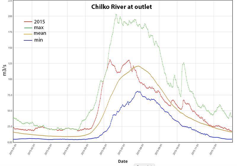
FLOW OF CHILKO at outlet from Chilko Lake (red is 2015 trace; min, historical mean and max indicated):
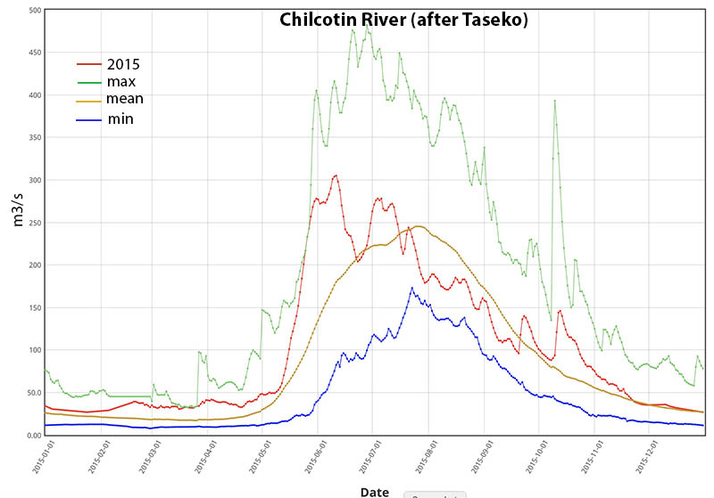
FLOW OF CHILCOTIN below the Taseko confluence (red is 2015 trace; min, historical mean and max indicated):
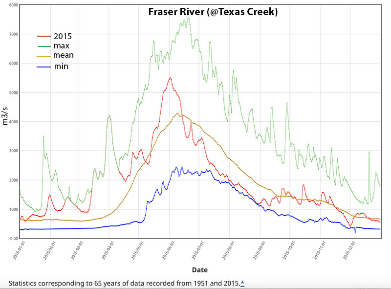
FLOW OF FRASER at Texas Creek (near Bridge River confluence): red is 2015 trace; other traces are historical min, mean and max:
A FEW COMMENTS FROM PAST PARTICIPANTS:
"XX. "
Cliff Loucks; Oarsman on 26Jul2022 Chilko-Fraser expedition (has rowed Colorado GC >6X, Marañon, BlueNile, many long rivers)