|
RÍO MEZQUITAL: Spectacular remote Grand Canyon of Mexico |
|
294 km (182 miles, class V, 15 days (14 on water) |
| departures: Sep24 (2023) . RESERVE NOW |
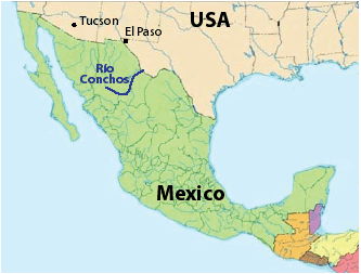
Río Mezquital-SanPedro flows through what is probably the most remote long canyon in Mexico with only one road access point for nearly its entire length, and features numerous high-walled gorges with some of the most spectacular scenery a river can offer. The bar is high to successfully descend this river as there are over a dozen class V rapids to navigate (though we have taken rafts without any portages). If you're up to the challenge and make it through successfully, you won't be disappointed - and you can relish that you've done the river before a massive dam planned at the end is constructed (Hidroeléctrica Las Cruces),
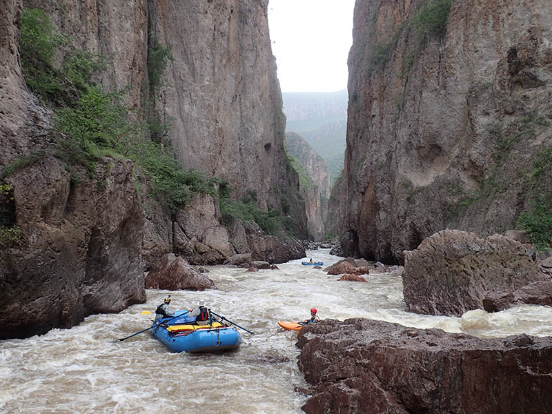
This trip on Río Mezquital will start at the Puente Guamuchil road bridge located ~70 km downstream of the town of Mezquital. We base the trip at the large beach town of Mazatlán, which is located on the road between the take-out ane put-in. It takes much of a day to just get to the river. Once there, we will assess the flow and decide if we're going to attempt the river. The first 5-6 days of the trip are intense with the group passing through a higher gradient section with many boxed-in gorges and class IV and V rapids. Lower water makes the rapids safer but more technical and prone to broaches and pins, while high water leads to innumerable raft-flipping and kayak-eating holes. Camps are remote and sometimes on beautiful beaches. Side hikes to waterfalls, slot gorges and even up to the rim can be done in this "Main" section of the trip. Midway down there is a potential access on a 4WD road to a village that allows the lower part of the river to be done over the last 5-6 days, where it is known as Río San Pedro. As on all our trips, we welcome competent paddlers and oarsmen who can reserve a raft or kayak: bring your own boat or use one of ours.
TENTATIVE ITINERARY:
DAY 0: flights into Mazatlán or Durango; transfer to hotel; ~7 pm restaurant welcome dinner; hotel
DAY 1: depart after breakfast ~8 am; drive Mazatlán to Durango and then to Mezquital ~7 hr; camping
DAY 2: rigging; start downstream; [maybe explore the section upstream by the landslide]; km 0-5
DAY 3: Crux1section (gorges); class V; ~km 15;
DAY 4: Crux2 section (LasJoyas; km 23-26); steepest part of river; possible portages; class V; km 26
DAY 5: Cascada Alisos; Taxicaringa; many IVs; Teneraca trail access; class IV-V; ~km 37
DAY 6: Rapidos Citricos; A.Las Palmas; to Peñas Blancas : ; ~km 57
DAY 7: LAYOVER (celebrate! through the class Vs!); ~km 57
DAY 8: Lajas confluence (km 67); to La Muralla trails; class IV; ~km 80
DAY 9: Easier river; III-IV; to ~km 120
DAY 10: Pass San Augustin access (km136); into Hormigas section (IV; km154-160); class III; ~km 156
DAY 11: LAYOVER
DAY 12: Through Red Granite Gorge to easier fast big river; Pajaritos (km 188); class III-IV; ~km 200
DAY 13: Huicholes Gorge; to Las Cruces Dam site; km 235
DAY 14: to take-out Venados (maybe to Ruiz); km 260 (285); drive to Mazatlán or PV; HOTEL
DAY 15: flights out possibler
Note: if the river is running high (>60 cms at put-in) or low (<10 cms), possibly only kayaks will attempt first section; if raging (>100 cfs), we will consider alternate options or hike in at Teneraca put-in. There can be problems and delays due to portages/etc. The layovers are budgeted here to allow extra time to deal with any such circumstances, and if no big delays happen, use the layovers to rest and explore/hike more.
COST
We welcome everyone on the trip: raft passengers, raft paddlers, raft rowers, kayakers and river guides. It is important on this trip to have prior rafting experience on class IV rivers. We offer professional level service similar to other established outfitters. The general costs of this and other trips and what's included are listed at: TRIP COSTS
RESERVATIONS
If interested in joining a trip, start a discussion by sending a note stating how you found out about the trip and a little background info about you and your paddling experience. Once you get the go-ahead, you will need to provide a deposit to reserve your place on the trip. The balance must be received 2 weeks prior to trip commencement. See PAYMENTS for payment options.
HEALTH
(click here)
FOOD/ALCOHOL/WATER
(click here)
CHORES, TOILET AND BATHING
(click here)
WHAT TO PACK
(click here)
SAFETY
On our trips we will have experienced river guides trained in whitewater technique, swiftwater rescue and wilderness first responder (or other advanced medical care). Captains of rafts will be experienced oarsmen who also have plenty of paddle-raft guiding time. We will stop and scout all major rapids, and it is up to each raft captain, kayaker, and passenger to decide whether to proceed to run the rapid with the particular safety arrangement in place. If someone is not comfortable going through a particular rapid, that person will have the option to walk around (all rapids on this river can be portaged.). In all cases, both captains and passengers must be comfortable with the arrangement to proceed through any rapids. With intermediate kayakers in the water, there will be at least one expert kayaker along to help out in rapids class III and tougher. We will take all other standard precautions on this river, including having everyone wear PFDs and helmets while on the water going through riffles or rapids. In addition, we generally will have one or more safety kayakers in class IV and V rapids who can aid swimmers in the event of washouts, raft flips, or kayakers swimming.
The violence in Mexico surrounding the drug was has been in the news a lot in the past years. The violence is generally confined to drug traffickers (narcos) and those associated with them, including law enforcement. Wile this river flows through a region where there is marijuana and opium cultivation, we generally have had friendly relations with the farmers and narcos who we've met (they are not very interested in molesting tourists). For further discussion of the drug war and safety concerns, click here.
WATER LEVELS
We have timed this trip to coincide with highest probability of good river flows. Due to the very difficult class V nature of the initial ~40 km of the trip, it is imperative to have optimal medium flow at the start and for the first several days. Once past the class V section, the flow can go much lower than average or even much higher, and we'll still be fine to safely descend the rest of the river (which is class IV max). We time our descents with the highest probability of encountering optimal water levels at the start (for both rafts and kayaks), which means launches generally in August or September. The flow at the put-in of Puente Guamuchil has a mean of ~50 cms (~1800 cfs) during these months, while the median flow is only ~25 cms (~900 cfs). That difference between mean and median means that often the river is raging, and when not, it's generally running pretty low. This is partly a consequence of a number of upstream irrigation reservoirs in the uppermost tributaries of the river (upstream of the city of Durango). In most water years, the reservoirs do not fill and all water is removed for irrigation into canals, not reaching the river farther downstream. However, in good water years when there's so much rain that these reservoirs fill, they start spilling, leading to the full natural flow of the river, which means somewhat of a boom-or-bust type of river just downstream of Durango. Fortunately, the put-in for the Mezquital is >150 km downstream of this area, meaning there are a lot more natural tributaries that feed into the river and give it natural flow despite the upstream reservoirs. So where we put-in on the river, there is a mix of natural flow and also possibly flow spilling from the reservoirs. When the reservoirs spill, they often will do so for a week or two after a good rain, meaning an extended season (often well into October). We want a medium flow at the put-in generally of 20-50 cms, which would be ideal for rafts and has been encountered about 50% of the time in August and September. We also want that flow to be relatively stable, which is hard to predict given the rain-fed nature of the drainage. If the flow is too high (>60 cms) or too low (<15 cms) and the forecast does not look promising for it to move into or stay in the appropriate target zone, an alternate river plan can be implemented (this will be elaborated in the PRE-TRIP INFO email that you receive). Unfortunately, there are no online guages for this river, so you can't know the flow easily without going there or knowing someone who lives near the put-in and can assess the flow for you. When on this river, you must be prepared for wild fluctuations in flow due to the rain-fed nature. We may encounter rapidly rising river that reaches camp, even if it's not raining, so camps must be set at a high enough location that you will not be flooded in the middle of the night. Conversely, if you start on low flows hoping for some boosts due to rain and it never materializes, you might have a very hard time getting the rafts through the difficult initial class V section (many portages an delays). Kayaks and packrafts are better in this sense as they can handle the lower flows more comfortably and still have a fun trip.
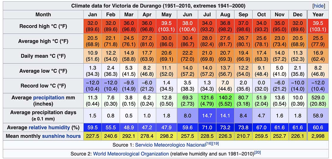
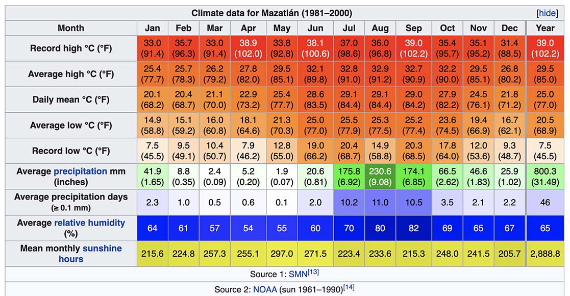
CLIMATE
This trip starts at medium elevation of appx. 1400m and ends at near sea level ~10m (30 ft), and due to this, in the first part of the expedition the nights are generally cool with warm to hot days, while farther down nights can also be very warm and daysa are generally hot. The city of Durango is upstream and quite a bit higher in elevation compared to the put-in, so you can expect several degrees warmer temps both day and night compared to the first climate chart below. Farther down on the river, the climate approximates more that of Mazatlán - though sometimes is even hotter being removed from the ocean with its cooling breezes. We only run this trip in the rainy season, so we generally will experience thunderstorms and rain on some evenings. Come prepared for this type of weather.