|
RÍO MARAÑON: The Grand Canyon of the Amazon |
|
499 km (310 miles), class IV, 12-26 days |
| launches: Jun28 Aug20 Oct10 RESERVE |
| OTHER TRIPS |
| versión ESPAÑOL |
The Upper Amazon River (Río Marañon) in the Andes offers the finest raft-support trip in South America. Join our raft/kayak expedition as we paddle 499 km (310 miles) through the scenic and arid Grand Canyon section, with exhilarating class III-IV rapids, soothing hot springs, amazing side hikes, beautiful clean beach camps, and Incan ruins. Spread the word about the consequences of ~15 planned dams and help us SAVE RÍO MARAÑON!
You also might have the option of continuing into the Jungle Pongos where the river goes through lush jungle.
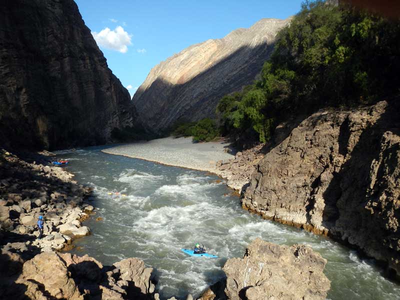
Río Marañon is the parent stream or "mainstem" source of the Amazon, meeting no stronger rival at any junction on its route to the Atlantic. It therefore is the Upper Amazon and the only stream meriting this title. From its birthplaces at glaciers on the highest tropical mountains in the world [Yerupajá and Huascarán; 6600-6800 m (21000-22000 ft)], the Marañon courses north over about 1/3 of the length of the country of Peru in the central Andes. As it does so, it is squeezed into the bottom of an arid canyon up to 3000 m (10000 ft) deep on both sides - more than double the depth of Arizona's Grand Canyon. A SierraRios expedition in 2012 explored what the Marañón was like, and learned of plans for over a dozen hydroelectric dams. The next expeditions are intended to increase appreciation of the river so more authoritative opinions can be formed against the dams. Voice your opinion now in the SAVE RIO MARANON campaign. Sign a petition! Watch a film. Make the issue known. Support the cause with a donation! The trips are open to everyone: rafters, kayakers, IKers, and passengers. No prior whitewater experience is necessary on a raft.
The Grand Canyon Amazon is divided into four sections:
Upper: 127 km; class IV; ~7 days; Puchka-to-Huchus
InnerGorge: 81 km; class IV(V); ~5 days; Huchus-to-Chagual
Central:149 km; class II-III (IV); ~7 days; Chagual-to-Balsas
Lower: 143 km; class III-IV; ~7 days; Balsas-to-P.Malleta
- Expeditions launching May-Oct (low water) will begin at Puchka.
- Expeditions launching Nov-Apr (high water) will begin at Chagual.
- Some expeditions will continue into the Jungle Pongos section.
- lt is possible to join or leave any expedition at any access point.
- Private groups are welcome to schedule a trip - either as a fully guided trip or a self-organized trip. Do it soon and help us save the river!
EMAIL LIST: Sign up for our email list (send an email to Rocky) and you'll be be advised of upcoming trips and often special lower rates compared to the general contribution rate.

| MORE INFO: |
| 2012 trip (First Descent Amazon) |
| OUTFITTING SERVICE |
| SPOT (latest GPS position) |
| PAYMENTS |
| -------------------------------------------- |
| Trip reports: Sep28(2013) |
| Jan16(2014) :: Jun4(2014) |
| Oct14 info :: Oct30 info |
MARAÑON SECTIONS:
The "Grand Canyon Amazon" refers to the profound canyon section of Río Marañon located downsteam of the Río Puchka confluence and upstream of the Jungle Pongos section. This canyon is generally 2600-3000 m (8000-10000 ft) deep on both sides throughout its length. Access points conveniently divide it into four sections, each with various difficulties and other features. These are summarized in the table below to help you decide the best trip for you. In general, the river is class III-IV in difficulty and comparable to the Grand Canyon of the Colorado (GCC), though some rapids of the Upper Grand Canyon Amazon section are considerably more challenging.
Anyone (even folks with no river experience) can always join a normal SierraRios trip through any section scheduled and have experienced class V guides lead the trip. Ideally, participants in charge of a raft or kayak should feel challenged, but not scared. If you're planning to row or kayak, you should note the difficulties below. It is always possible to avoid the tough Inner Gorge section by joining an expedition at Chagual (which can be arranged even for expeditions launching on the Upper) or taking a shuttle around it. It's best to discuss this possibility with the trip planner, as we can usually accommodate some class III boaters even on the Upper section.
| section | km | days | class | rapids | scenery | hikes | cultural | note | |
| Upper GC | 127 | ~7 | IV | +++++ | +++++ | ++++ | ++ | one of the best week-long trips in Peru | |
| Inner Gorge GC | 81 | ~5 | IV (V) | +++++ | +++++ | +++ | + | lining/portage at Wasson's | |
| Central GC | 149 | ~7 | II-III (IV) | +++ | +++++ | +++++ | +++ | most rapids at start and end of section | |
| Lower GC | 143 | ~7 | III-IV | ++++ | +++ | +++ | ++++ | soon to be dammed | |
| Bagua Valley | 81 | ~2 | I-II | + | ++ | + | ++ | flat and sometimes windy | |
| Jungle Pongos1 | 85 | ~3 | III+ | +++ | +++ | ++ | +++++ | often rainy; need Awajún permission | |
| Jungle Pongos2 | 215 | ~6 | I-II (III) | + | +++ | + | ++++ | need Awajún permission | |
| -------------------------- | -- | --- | --- | --- | --- | --- | --- | -------------------------- | |
| TOTAL RAFTABLE | 881 | 36 | - | - | - | - | - | awesome long Upper Amazon trip |
====================================================================================
Upper Grand Canyon Amazon (Puchka section)
class IV
127 km (79 miles) ; ~7 days
Puchka (2080 m) to Huchus (1600 m) [6900 ft to 5280 ft];
4.0 m/km (22 ft/mile)
Google Maps (put-in area)
The Upper Grand Canyon Amazon section is filled with class III and IV rapids and most folks usually consider it a little more challenging than the Grand Canyon Colorado. The UpperGC section is quite scenic in arid canyon and has numerous interesting side excursions - to narrows, waterfalls, and ruins. There are some residents to encounter but not many, so cultural interactions are usually minimal. The three toughest rapids are Pauca (IV), Sanachgán (IV), and Shapalmonte (IV). At high flows these rapids have high raft flip potential (rating of 10 on GC scale) and while not more dangerous than Lava Falls, one is difficult to portage (Shapalmonte). Some rapids are very long, including Huaycanoragra, Yesojirca Narrows, and Sanachgán. This section has an easy access point at Puente Jitaraxan/Comara (km 100) at the road bridge joining the towns of Sihuas and Tayabamba, and can also be accessed at Huchus (km 127). At least two dams are planned for this section. See slideshows of this section at low and high water:
PUCHKA SECTION SLIDESHOW Jan16 [from the Jan16 (2014) trip]
PUCHKA SECTION SLIDESHOW_Sep28 [from the Sep28 (2013) trip]
====================================================================================
Inner Gorge Grand Canyon Amazon
class IV (V)
81 km (49 miles) ; ~5 days
Huchus (1600 m) to Chagual (1260 m) [5280 ft to 4160 ft];
4.2 m/km (23 ft/mile)
Google Maps (put-in area)
The Inner Gorge section is 81 km from Huchus to Chagual and significantly more difficult than the Grand Canyon Colorado. The section starts with ~20 km of class III passing a great hot-springs to soak in. The river then enters the bona fide Inner Gorge, which has numerous class IIIs and IVs as well as an intimidating class V (Wasson's Landslide) and a more runnable V- (Llamara). There are several dangers in Wasson's: (a) stopping just before the main rapid is often difficult as there are no good eddies, (b) there is a series of difficult drops/holes in the main ~200 m-long rapid that can cause flips/problems, and (c) at lower flows there is a sieve at the end of the rapid that half the river goes into. We have lined or portaged rafts through Wasson's for safety, a process that can take much of a day. At high flows, although it is easier to stop at the top, it can be more difficult to line rafts. The other class V is Llamara - which is about 500 m long with lots of class IV and one steeper ledge drop in some places into a hole. We often run rafts and kayaks over its main ledge drop, but if problems are encountered, the long class IV runout can be a problem. Other notable class IVs are Mayas, Ihuano, the runout at Wasson's, Rupaybamba, Chayalo, Pinto, Chinchango, and Carrizal. It is possible to circumvent the whole Inner Gorge section by taking a vehicle from Huchus to Chagual or from Puente Jitaraxan to Chagual. It is also possible for some participants to hike up and out of the Inner Gorge just before Wasson's to Chillia, and then take a bus/taxi back to the river at Chagual. At least 2 dams are planned for this section - President Humala was in Chaugal in January 2015 promoting the dam to be built just upstream. See a slideshow of the Inner Gorge at low water:
INNER GORGE SLIDESHOW [from the Sep28 (2013) trip]
====================================================================================
Central Grand Canyon Amazon
class II-III (IV)
149 km (93 miles); ~7 days
Chagual (1260m) to Balsas (860m) [4160 ft to 2830 ft]
2.7 m/km (15 ft/mile)
Google Maps (Chagual)
The Central Grand Canyon Amazon section is mostly class II-III but with one tougher rapid (a long IV) at the end. Anyone comfortable rowing/paddling the Grand Canyon Colorado or Salmon should be comfortable on this section. The long IV is Samosierra (aka Bombón), a rapid first described by the CanoAndes crew in 1980 and approximately a 9 or 10 on the GC scale. This Central Grand Canyon Amazon section features spectacular scenery, passing through arid desert-like canyon with sparse vegetation and numerous cacti, as well as many vertical walls rising directly from the riverbed. One of the most incredible spots along the river is the Muro Poso, a huge Zion-like wall with 400+ m waterfall coming almost directly down into the river. Other side excursions can be taken to pre-Incan tombs, up mountainsides, and into side canyons with incredible grottos (Llanten), dry mud-flows, waterfalls, and narrows. There are several pueblos along the way, including Calemar, which has the preserved casa of famed author Ciro Alegria. These pueblos allow for a good amount of cultural interactions with the local residents. At least two dams (Rio Grande I and II) are planned for the lower part of this section, but the residents are mobilizing against them.
See slideshows of this section on various trips:
MIDDLE GC SLIDESHOW_Jan16 [from the Jan16 (2014) trip]
MIDDLE GC SLIDESHOW_Sep28 [from the Sep28 (2013) trip]
====================================================================================
Lower Grand Canyon Amazon
class III-IV
144 km (89 miles); ~7 days
Balsas (860m) to Puerto Malleta (500m) [2830 ft to 1650 ft]
2.5 m/km (14 ft/mile)
Google Maps (Balsas)
The Lower Grand Canyon Amazon section is class III-IV with rapids interspersed throughout its length. It is equivalent in difficulty to the Grand Canyon of the Colorado, MF-Main Salmon, Sun Kosi, or Zanskar. The biggest rapids are El Choclón, Tupén Grande, San Lucas, Playa El Inca, Magdalena, and Linlín. Although some of these rapids are quite long, they are not more difficult than the toughest rapids on the Grand Canyon Colorado, even at high flows. The scenery of the Lower Grand Canyon Amazon is pleasant, starting out in a dry cactus-studded canyon and getting more and more annual precipiation with additional vegetation before becoming quite dry again in the Bagua Valley section. There are numerous side excursions - to the pueblos of Mendán and La Mushka, to abandoned pre-Incan overlooks and Incan tombs, to narrows, and to an intriguing series of swiming pools. It is important to have approval of the local communities in this section as they can be hostile to you if they don't know you and suspect you may be with the dam companies (see C&K article; but read comments at end). This section has the dams in the latest planning stages: Chadin 2 and Veracruz. It will likely be the first to be drowned by reservoirs. The first take-out as the canyon opens up is Puerto Malleta, about a 1.5 hr drive from Bagua Chica. From here, it is possible to paddle up to 80 km through the Bagua Valley section (class I-II) to Rentema, the start of the Jungle Pongos section. Two dams (Chadin2 and Veracruz) are already approved to be built and will flood the entire LowerGC section, but residents and SierraRios opposition seem to be delaying the Chadin2 dam.
See slideshows of this section at low and high water:
LOWER GC SLIDESHOW_Jan16 [from the Jan16 (2014) trip]
LOWER GC SLIDESHOW_Sep28 [from the Sep28 (2013) trip]
====================================================================================
Jungle Pongos
The Marañon continues downstream of the Lower Grand Canyon Amazon section into the Bagua Valley and the the Jungle Pongos for an additional ~300 km before exiting the Andes into the flat Amazon basin. Some trips will continue into the jungle. For more information on these sections, see Jungle Pongos.
====================================================================================
Prior descents:
Río Marañon has had only 3 near-complete descents
John Wasson et al., 1977: Paddled 790 km with 3 kayaks and a 12' raft from Rondos to Imacita (Nazareth) [Jul-Aug].
Tim Biggs et al., 2004: Kayaked all 1750 km in kayaks from Río Nupe to Iquitos: the entire river. [July 2004]
Contos et al., 2012: Boated all 1750 km river: "Headwaters" 200 km in kayaks (8 days), "Grand Canyon" 650 km with cataraft, 2 kayaks, and IK (28 days); "Lower Jungle" ~900 km to Iquitos in motorboats (7 days) [July 2012]
and many partial descents:
La Condamine 1743: rafted from Chiriaco confluence to Borja [then ship to the mouth of the Amazon]. [Jun-Sep, 1743]
Arturo Weatherman 1870: rafted from Utcubamba confluence down to past the Pongo de Manseriche.
Herbert Rittlinger, 1936: Attempted descent in Folbot kayak from near Rondos but aborted. Book sold 300,000 copies!
Laszlo Berty, 1976, 1977: Rafted ~450 km (maybe solo?) from Chagual to jungle (summer low water).
Andrzej Pietowski et al., 1981: Rafted 148 km from Chagual to Balsas only. [March 23-25, 1981]
Dignum et al.,1987: Group of 4 Dutch rafted 206 km section from near P.Copuma to Chagual. [Oct 1987]
Kurt Casey et al., 2000: Kayaked from Vizcarra confluence down to Chagual only. [July 9-18, 2000]
Dam survey parties, 2011-2013: [sections of the river between Chagual and Rentema (2009 to 2012)]
SierraRios trip Sep28 2013: Group of 19-24; 30 days led by Contos: Puchka to Imacita.
SierraRios trip Jan16 2014: Group of 19-24; 29 days led by Contos: Puchka to Imacita.
SierraRios trip Jun4 2014: Group of 16-19; 29 days led by Contos: Puchka to Montenegro.
SierraRios trip Sep22 2014: Private group of 16 (Landes); guided by Contos/Peña; 15 days Chagual to P.Malleta
SierraRios trip Oct1 2014: Private group of 18 (Gayner); guided by Contos/Baca; 18 days Chagual to Montenegro
SierraRios trip Oct14 2014: Group of 12-14; 29 days led by Contos/Peña: Puchka to Montenegro
SierraRios trip Oct29 2014: Group of 10-14; 29 days led by Baca: Puchka to Montenegro
SierraRios trip Nov22 2014: Private group of 16 (McColluch) guided by Peña/Bergamin; 15 days Chagual to P.Malleta
SierraRios trip Dec4 2014: Group of 12; 16 days led by Contos/Peña: Puchka to Imacita
SierraRios trip Jan7 2015: Private group of 15 (Drevo/Rae) guided by Peña/Bergamin; 15 days Chagual to P.Malleta
Personality/Experience:
No river rafting experienced is required to join a trip. However, you should be comfortable camping and you should have an easygoing attitude in order to get along with a diverse group on a Grand Canyon-style trip for an extended period. If you are concerned about this issue, consider arranging a private trip (contact Rocky) or if you're an experienced group, contracting our outfitting services. Note that in some sections of the river, it is essential to have someone along (a guide) who knows the people to ensure friendly interactions.
Everyone joining SierraRios trips should have an interest in river conservation and help us on our mission to document the river further, talk to residents, publicize the planned dams, and help train local guides. We welcome competent boaters. If you want to kayak, you must have adequate class IV experience and a solid roll. If you want to row a raft, you must have adequate experience rowing class IV rivers. Comparable rivers are the Colorado (Grand Canyon), Middle Fork Salmon, Thompson, Futaleufu, Karnali, Yangtze (Great Bend), and Zanskar. You should be in good physical condition. In general the pace is relaxed with several layover days, but there may be some long days on the water. You should plan to help facilitate the trip in any way possible, including transport of some gear down to Peru and to the river if necessary. You don't need to be bilingual but it is helpful and more fulfilling to communicate with local residents when we meet them.
Leadership/Decisions:
The policy we will take on the trip is that the trip leader will have main authority when it comes to decisions for the group regarding river progress, camp, etc. If a participant has overestimated their ability to row or kayak, he/she may be mandated to ride on a raft and or be assessed other penalties. Trip leader decisions can be vetoed by a majority vote of the group. Any participant always has the right to leave the trip if they so desire.
RENDEZVOUS POINTS/TRANSPORTATION
HUARAZ: The main rendezvous point for Upper launches will be Huaraz. You should arrive 1-2 days before the launch date. We will arrange transportation for the ~7 hr drive to the put-in near the pueblo of Huacaybamba on departure day. We may visit the ruins at Chavin de Huantar in the morning enroute and camp at the put-in after starting to rig boats. Huaraz is a beautiful colonial city at 3000 m elevation and a major outpost in the Andes for trekkers and climbers, as it's close to the highest tropical mountains in the world, including Huascarán. You might consider doing several days trekking before the trip, such as to the Cordillera Huayhuash, one of the principal sources of the Amazon. To get to Huaraz from Lima, you can fly (1 hr) or take a bus (8 hr). Flights are only operated by LC Peru. There are two primary bus companies servicing Lima-Huaraz with ~8 hr rides (links below). On these buses there are regular seats, semi-reclining seats, and sometimes "cama" seats that recline almost fully. Prices are about $11-32 for the ride depending on seat type (note some buses are all cama seats; some have mixed seats, etc): Movil Tours (Paseo de la República 749, La Victoria; tel: 332-0004) has departures throughout day for 40-80NS ($15-32): e.g., 8:00am, 9:40am, 10:10am, 10:30am; 1:00pm, 9:40pm, 10:30pm; Cruz del Sur (Javier Prado & Arriola) has departures usually 11:00am and 10:30pm from Javier Prado for 30-80NS ($11-32) depending on seat type
TRUJILLO / CHAGUAL: Chagual is the pueblo along Río Marañon dividing the Upper Grand Canyon Amazon from the Central Grand Canyon Amazon. You can arrive here from Trujillo by either bus (~$20; 12 hr; Transportes Hucomi) or flight ($140; 1 hr; Atasur; departures 7am Tue, Thur, Sat). It is possible to enter or exit the trip at Chagual - check with the trip planner if you would like to join or leave the expedition here.
BALSAS / CAJAMARCA: Balsas is a pueblo by the river dividing the Middle Grand Canyon Amazon section from the Lower Grand Canyon Amazon section. From the river access bridge at Balsas it is a 1.7 hr drive up to Celendín (taxi), and then a 3 hr ride to Cajamarca (bus or taxi). Regular flights and buses serve Cajamarca to/from Lima. Two domestic carriers service Cajamarca-Lima (LAN and LC Peru) for $120-180 one-way. You can also take a 14 hr bus to Lima ($30) - some are quite comfortable with reclining "cama" seats.
BAGUA: If you continue down through the Lower Grand Canyon Amazon with us, the end city rendezvous is Bagua (or more precisely Bagua Chica to distinguish from Bagua Grande/Utcubamba nearby). Bagua can be arrived at from Puerto Malleta (1.5 hr), Cumba (1 hr), Corral Quemado (0.5 hr), Rentema (0.5 hr), Imacita (3 hr), Nieva (7 hr), or Sarameriza (11 hr). The Puerto Malleta access is convenient for those ending their trip after all the rapids of the Grand Canyon Amazon section - it avoids the flat Bagua Valley section, though it is also possible to paddle downstream to take-outs at Cumba or Corral Quemado (where a highway bridge crosses the river). From Bagua it is a 4-6 hr bus ride to Chiclayo, where you can find regular commercial flights (1 hr) and bus service (10 hr) to Lima. Alternatively, you can go to Tarapoto (~8 hr ride to the east) which has more and cheaper flights to Lima. For flights, check STAR, LAN, PeruvianAir, or LC Peru. On all SierraRios trips or outfitted trips the shuttle to Bagua is included in the cost.
TENTATIVE ITINERARY:
This is for the full Grand Canyon Amazon trip (Upper+InnerGorge+Central+Lower); launches Nov-Apr start on Central):
Day 0: rendezvous in Huaraz; meet Rocky or trip leader
Day 1: take bus and/or vans toward Puchka put-in (near Hucrachuco); start rigging; camp
Day 2-8: Upper GC to Huchus (km 0-127); many IIIs and IVs; Shapalmonte (IV); 1 layover
Day 9-13: Inner Gorge GC to Chagual (km 127-206); many IVs; two Vs (Wasson's Landslide & Llamara); 1 layover
Day 13-18: Central GC section Chagual to Balsas (km 206-357); II-III; ends with IV (Samosierra); 1 layover
Day 18: Arrive Balsas get ride up to Celendín (2 hr); possibly to Cajamarca (3 hr more); hotel
Day 19: in Celendín/Cajamarca; exchange participants; resupply/repack food; hotel in Cajamarca or Celendín
Day 20-26: Lower GC section: Balsas to Puerto Malleta (km 357-516); class III-IV;1 layoverI
From here down you might continue into the Jungle Pongos trip (2-8 extra days)
Expected Progress:
We will usually paddle through the entire Upper section in 12-13 days (arriving in Chagual on Day13), the Central section in 6-7 days, and the Lower section in 7 days. This includes plenty of time for side hikes as well as several layover days. On full trips, we will arrive in Balsas in the afternoon and head up out of the canyon in a taxi or combi to Celendín or Leymebamba/Kuelap while some remain with the boats at the river for a layover day. The following day will be spent visiting one of these cities/ruins and in passenger exchanges. We may arrange to have meetings with residents of the area (e.g., in Celendín) to discuss the dams.
Sites/Excursions:
Aside from excursions during the river trip, you might consider visiting other interesting places in northern Peru, including the Incan/colonial city of Cajamarca, various thermal baths nearby, natural wonders such as the Catarata de Gocta (771 m high and one of the tallest waterfalls in the world), as well as many ruins such as Caral, the oldest known city in the Americas (near Barrancas on the coast), Kuelap, the Machu Picchu equivalent of the Chacahpoyas culture (near Chachapoyas), and Chavín de Huantar, a site worth a stop enroute to the Puchka put-in. Note that Cajamarca was a major Incan city and the site where Pizarro met and defeated Atahualpa, who had recently assumed title of full emperor of the Inca after defeating his brother Huáscar.
Maps:
SierraRios has all topo maps of the entire river marked with rapids and potential beach camps. If you would like access to these, you can sign up as a member of SierraRios specifying you're interested in the Marañon map/book/video, and you'll receive immediate access to the maps (book/DVD later). If you have the password, click here for access: MAPS. [also note links at top left column of this page and at TOPO MAPS on the main www.SierraRios.org homepage.
CLIMATE AND BUGS:
The trip occurs at tropical latitudes in semi-arid country and at moderate elevation. Average annual precipitation is about 450 mm (19 in) near Puchka and 330 mm (13 in) at Balsas. The elevation at the put-in is 6900 ft, so expect warm days and cool evenings in the initial sections (highs of 27oC/80oF and lows of 10oC/50oF are common the first days). Water is pretty cool (15-20oC) initially. After the first week of the trip, it will generally be hot (highs of 32oC/90oF and lows of 20oC/68oF generally) and the water warms up considerably (to ~23oC by the jungle).
There is almost no rain in the dry season May-Sep in the Upper Grand Canyon Amazon section, but expect some in the rainy season. On our July 2012 and June 2014 trips, we had only a few sprinkles of rain for the first 25 days. Once we entered the Jungle Pongos, we experienced rain every day or two, usually in short intense storms.
Although many camps have no biting bugs, in some camps there are annoying biting gnats and flies. Repellent works against these. Mosquitos are not common but are present at times in the dry canyon areas. They are much more common in the jungle. Other critters to beware of are spiders, scorpions, snakes, and giant centipedes.
CONTRIBUTION
This trip is being run to increase appreciation of the river and foment opposition to the planned dams. We welcome everyone: raft passengers, raft paddlers, raft rowers, kayakers, IKers, and guides. The pricing policy takes into account the costs associated with running the trip and the services offered. While typical rates are ~$4000 for a 14-day Grand Canyon trip or ~$2000 for a 6-day MF Salmon River trip, you can see that our rates for similar length trips where everything is taken care of are considerably lower:
Contribution guidelines: General
We strongly encourage potential participants to offer the general contribution rate if possible. Special discounts are sometimes offered to folks on our email list, so you are encouraged to sign up (Email List info). Reduced rates may also be granted to certain participants with more limited financial means. This can be to raft guides, safety kayakers, and experienced oarsmen willing to work on the trip, to others who can help with publicity and/or fill the trip, and to anti-dam activists who will be instrumental in protecting the river. Please send an inquiry to Rocky if you would like to be considered for a reduced rate, and keep in mind what basic Outfitting Services cost for a trip.
RESERVATIONS
If interested in joining a trip, start a discussion by sending Rocky a note (rocky@sierrarios.org) stating how you found out about the trip and a little background info about you and your paddling experience, what dates might work for you, and what sections of the expedition you are most interested in joining. Once you get the go-ahead from Rocky, you will need to provide a deposit to reserve your place on the trip ($1000 for full trip). The balance must be received prior to trip commencement. See PAYMENTS for payment options.
As of January 2015, participant totals for the UPPER / CENTRAL / LOWER [+2 guides]
12/02/02 Jun28 launch: UPPER / CENTRAL / LOWER [+2 guides]
00/00/00 Aug20 launch: UPPER / CENTRAL / LOWER [+2 guides]
00/00/00 Oct10 launch: UPPER / CENTRAL / LOWER [+2 guides]
A minimum of 8 particpants will assure a general SierraRios trip occurs, while our maximal limit is 20 on any trip. We may allow trips with fewer folks depending on circumstances. The current boats available allow for two trips at a time. If interested in doing a trip on a date not listed, send Rocky a message about optimal scheduling for you, as well as a little info about you. We may list the launch date, and if enough folks sign up by the 3-month cut-off, we'll organize it.
CANCELLATIONS:
We reserve the right to cancel the trip 2+ months in advance. This generally will occur only if there are not enough folks signed up (<12). If we cancel the trip, all deposits and payments will be refunded.
If you must cancel, you'll get your money back if you find someone to take your place on the trip. If you don't find someone, we may allow much of the payment to be applied to a future trip (at our discretion). The amount depends on the circumstances surrounding the cancellation.
TRIP LEADERS AND TEAM MEMBERS:
(see individual trip info pages for details - links at top)
(1) Rocky Contos (scheduled trip leader on most 2014 launches), descended the entire Marañon from its headwaters on Río Lauricocha to Iquitos from July to September 2012, and led three 20+ person 30-day expeditions in 2013 (Sep28) and 2014 (Jan16 and Jun4). He discovered the most distant source of the Amazon [see articles C&K, Outside, Nat.Geo, FoxNews, LaRepublica] and in 2012, also paddled all of Ríos Apurímac, Mantaro, and Urubamba as part of his Headwaters of the Amazon expedition. He has explored nearly every river in Mexico including >100 first descents covering ~8,000 km of river and ~55,000 m of drop. Rocky believes the Marañon is one of the finest Grand Canyon-style raftable rivers in the South America. He is fluent in Spanish and has organized many Grand Canyon length trips. Several articles have featured Rocky (American Whitewater; Kayak Session; Canoe & Kayak). While attaining his Ph.D. in neuroscience (see CV), Rocky worked as a kayak instructor and guide for UCSD's Outback Adventures from 1993-1996 and gained valuable trip planning skills for large groups. Although primarily a kayaker, Rocky started rafting in the mid-1990s in order to introduce more people to the wonders of river travel. He has organized numerous large group raft and kayak expeditions through the Grand Canyon (7X), MF+Main Salmon River (4X), Río Mulatos-Aros (4X), Río Usumacinta (8X), Taseko-Chilcotin-Fraser (1X), and many other long trips to the Salt, Kern, Rogue, Deschutes, John Day, Thompson, Similkameen, and Baja California. Rocky founded SierraRios with the goal of conserving the rivers of Latin America, and hopes that increased awareness and enjoyment of the resource will lead to protection. He is organizing most aspects of the trips and will lead some but cannot lead all.
(2) Pedro Peña will be co-guide or trip leader on many expeditions. Pedro was born in Lunahuana near Lima and started kayaking and rafting at a young age on the Lunahuana. He has been a raft guide for most of this life on the Cañete, Apurímac, and Futaleufu. He rafted the Lower GC Amazon several times for dam survey crews but would not do so now for a love of the free-flowing river. He signed the PETITION and is working to help stop the dams.
(3) Julio Baca will be co-guide or trip leader on many expeditions. Julio was born in Curahuasi (near Cusco) and learned to paddle at a young age, advancing to class V ability in both kayaking and rafting. He lives in Cusco is typically guides the Apurimac and Urubamba in the main season (May-Sep) and then heads to the Futaleufu to guide during the season in Chile (Dec-Mar).
(4) Lorenzo Bergamin will be co-guide or trip leader on some expeditions. Born in Milan, Lorenzo grew up near the Alps with their great whitewater and fell in love with river running and guiding. He has traveled in 62 countries and paddled/guided rivers in many areas around the world, including the Grand Canyon (several times), Futaleufu, Zambezi, Sun Kosi, Karnali, and Tamur. Lorenzo speaks English, Italian, and Spanish. He may be more permanently based in Colorado in the future.
(5) Other river guides may be employed at times, including Alonso Campana ("Rambo") a class V rafter and kayaker who joined the Upper+Central GC Amazon trip Jan16 and runs his own rafting operation in Cusco (Apurimac Explorer), Victor Baca, a class IV-V kayaker/rafter from Cusco, and other Peruvian/Chilean guides learning the river this year.
(6) Eusebio Chumpi or other Awajún will be local guides with the group in the jungle Aguaruna areas. It is not possible to pass without approval from the Aguaruna nation [you will be detained and possibly robbed/attacked] and such local guides. Eusebio or his son Manasés Chumpi joined the 2012, 2013 and 2014 trips and will likely join future trips. In addition, sometimes we will have other Awajún with us, such as Segundo Valera, and local conservationist Luciano Troyes of Gotas de Agua.
SAFETY / HEALTH
(click here)
FOOD/ALCOHOL/WATER
(click here)
CHORES, TOILET AND BATHING
(click here)
WHAT TO PACK
(click here)
WATER LEVELS
See more info at Marañón Water Levels. The river is generally about the same volume as the Colorado through Grand Canyon.
| river | Ene | Feb | Mar | Abr | May | Jun | Jul | Ago | Sep | Oct | Nov | Dic | Avg | |
| Marañon (at Balsas) | cms | 640 | 920 | 980 | 870 | 410 | 210 | 140 | 130 | 140 | 240 | 450 | 580 | 475 |
| cfs | 22800 | 32700 | 34700 | 30600 | 14700 | 7500 | 5000 | 4600 | 5000 | 8400 | 16200 | 21400 | 17000 | |
| ---------------------------- | ----- | -------- | -------- | -------- | -------- | -------- | -------- | -------- | -------- | -------- | -------- | -------- | -------- | -------- |
| Colorado (LeesFerry) | cms | 148 | 188 | 259 | 560 | 1188 | 1476 | 597 | 293 | 234 | 234 | 175 | 163 | 486 |
| [pre-dam flows 1922-1962] | cfs | 5300 | 6700 | 9200 | 19900 | 42200 | 52400 | 21200 | 10400 | 8300 | 8300 | 7500 | 5800 | 16480 |


BOATS AVAILABLE IN PERU:
[current list available]
A FEW COMMENTS FROM PAST PARTICIPANTS:
"The Marañón resembles the Grand Canyon of Colorado in many ways with its rapids, beaches, side canyons and deep cacti-studded gorges. Both rivers offer numerous side-hikes and waterfalls. Like the Canyon, the Maranon is ideal for a long multi-day boat trip where a person can forget the grind of everyday life... However, the Maranon offers much more. Unlike the Grand Canyon, the Maranon is free flowing and its character can change overnight by the whims of nature. Its navigable section is much longer than that of Colorado and its canyon is deeper. Some Maranon beaches are big enough to accommodate small villages. The Maranon offers more and greater variety of rapids that are overall more challenging to navigate. Its continuously strong current makes it possible to easily cover 30-40 miles per day in a raft, assuming one does not stop for side hikes. The jungle area of the lower Maranon has no equivalent on the Colorado... I cannot think of another river in the lower 48 States that offers the same kind of experience."
Boris Trgovcich, class IV rafter/IKer and former raft tour operator in N.California. [2013Sep Marañon trip participant]
See Full Comment
"I found the river trip labeled the "Grand Canyon of the Amazon" to be completely comparable to the Grand Canyon of the Colorado in most respects, and it exceeded my expectations in every way... In the 1980s I paddled the Bio-Bio as a participant on one of the first commercial kayak trips in Chile [with] Chris Spelius. While [the Bio Bio's] destruction was abominable both environmentally and culturally, the size and importance of the Bio-Bio's destruction was but a small warning shot compared to the potential disaster planned for the Marañón/Amazon."
Kelly Kellstadt, class III-IV kayaker and former guide/instructor in New Mexico. [2013Sep Marañon trip participant]
See Full Comment
"I need to do another expedition!!!!! I'm already jonsing for one .... The Marañon trip was one of kind that I will never forget ... the perfect combination of big water, gorgeous scenery and a taste of rurual Peruvian lifestyle! ... I would do this trip again in a heart beat ... It really is amazing how helpful some people have been along the way. Going way out of their way in order to help..."
Amie Begg; class IV kayaker on 2012 Marañon trip
"The Marañon trip was a magical journey. Big, clean water; big canyons and expansive natural beauty; and big-hearted, friendly people who made us feel welcome along the way, while sharing with us their fears of imminent dams, mines, and petroleum drilling. I hope we can find a way to help them protect this incredible treasure and their ways of life."
Barbara Conboy; SierraRios board member and rafter/kayaker on 2012 Marañon trip