|
RÍO URUBAMBA: Jungle Run & Espiritú Pampa |
|
up to 560 km (347 miles), class III-IV then II then I; optional IV-V first day, 18 days |
| Trips can be anytime of year: rendezvous in Santa Teresa . RESERVE |
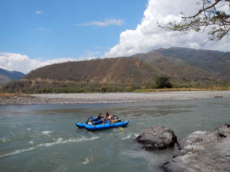
Here we continue the journey started on the Vilcanota/Upper Urubamba down the rest of the Urubamba into the jungle and to the end of the rapids on the river. Enjoy the hot springs at Santa Teresa, paddle through numerous class III-IV rapids down through the famous "Pongo de Mainique", camp on huge beaches, visit the real "Lost City of the Incas" that Hiram Bingham was actually looking for: Espiritú Pampa, and meet indiginous natives.
| TRIP INFORMATION |
| ITINERARY |
| RENDEZVOUS POINTS |
| PRICE & WHAT YOU GET |
| RESERVATIONS/PAYMENTS |
| YOUR GUIDES |
| FOOD, ALCOHOL, WATER |
| CHORES, TOILET, BATHING |
| IS IT SAFE? |
| GENERAL ROUTINE |
| WATER LEVELS |
| WHAT TO PACK |
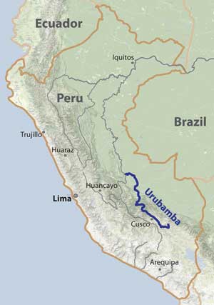
Río Vilcanota-Urubamba is one of the classic rivers of the world that has captured the attention of the paddling community for decades. This river flows by the heart of the Inca Empire and was formerly considered the source of the Amazon (from ~1900 to 1950). We will start our journey in Santa Teresa with an optional class IV-V day run, then meet the loaded rafts and rest of our group for the class III section down into the remote jungle areas past Quillabamba and Kiteni. We will stop for a 1-2 day excursion up to ruins of Espiritú Pampa near Kiteni before continuing downstream on the class II river to face the Pongo de Mainique: the final class III gorge with rapids on the Urubamba. Experience the transition to lush jungle and its associated wildlife, camp on huge pristine beaches, and paddle big-water rapids as you complete the Urubamba. The final days are relatively easy as we make our way all the way to Atalaya at the Tambo confluence. This trip is ideal for both those with and without paddling experience.
TENTATIVE ITINERARY:
Day 0: Arrive Santa Teresa; meet group, soak in Cocalmayo hot springs; camp at hot springs
Day 1: Paddle class V section to Santa Maria (17 km) or meet us there for the class III-IV section downstream; ~25 km
Day 2: Paddle to Quillabamba (37 km from ST); restaurant; visit Baños Sanbaray; hotel; class III-IV; ~30 km
Day 3: Class III-IV rapids in ever greener jungle; (km 50 from Quillabamba); ~25 km
Day 4: Paddle to Yanatile confluence (km 50 from Quillabamba); ~25 km
Day 5: Class II-III; camp; ~40 km
Day 6: Class II-III to Kiteni (km 125 from Quillabamba); hotel; ~35 km
Day 7: Layover: arrange ride up to Espiritú Pampa; Visit Espiritú Pampa; return to Kiteni; 0 km
Day 8: Class II jungle run to near Yavero (Paucartambo) confluence (km182); class II; ~50 km
Day 9: Into class III Pongo de Mainique (km 197-203); camp
Day 10: Class I-II section; 50 km (km 250);
Day 11: To Malvinas (km 270); resupply food; continue downstream to a camp (~km 290); class I-II; 40 km
Das 12: Full downstream progress; jungle paddle to km 350; class I-II; 60 km
Day 13: Paddle to km 400; camp; class I-II; 50 km
Day 14: Layover in nice jungle camp; hike into jungle
Day 15: Pass Sepahua (km 417); continue downstream (to ~km 450); class I-II;
Day 16: Continue downstream in jungle; (to km 500); class I; 50 km
Day 17: Long paddle to near Atalaya (km 560); hotel; class I; 60 km
Day 18: Rest day; arrange paddle downstream or bus/flight out; (bus ride out to Satipo is 7 hr).
Day 19: Bus ride to Huancayo (8 hr) or Lima (14 hr).
Expected Progress:
To paddle the entire distance of 560 km (347 miles) in 16 days with several half-days for hikes, we will need to progress about 40-50 km/day on full paddling days. This should be easily accomplished but does entail prompt departures in the mornings. We will try to be on the water by 9 am.
Personality/Experience:
You should be able to get along with a group of paddlers for a week. You do not need whitewater experience to enjoy this trip, but it helps. The section of the Urubamba from Santa Maria down is commonly rafted (with guides) by inexperienced people, and we will gladly guide several such folks on our rafts. You don't need to be bilingual but it is helpful.
Leadership/Decisions:
The trip leader (Rocky) will have main authority when it comes to decisions for the group regarding river progress, camps, and other group decisions. The river is near road access every day so if there are problems, it is easy to leave the river trip and/or obtain help.
Maps:
Rocky has all topo maps of the entire river and knows where rapids, camps, and sites of interest are located. When you sign on to the trip, you will gain access to them so you can view and print out a copy for yourself.
Pollution: Pollution along the lower Urubamba is not as notable as in the lower Sacred Valley, since the water is diluted significantly. Water quality is still poor, so we will not drink it. Also, expect to encounter trash on the sides in some places.
RENDEZVOUS POINTS/TRANSPORTATION
The main rendezvous points will be Ollantaytambo, Machu Picchu, or Santa Teresa. We will be continuing a journey started on the upper Vilcanota and going through these sites for 3 days immediately before the trip commences at Santa Teresa. You are welcome to join us in visiting Machu Picchu. Otherwise, you can get to Santa Teresa by taking a bus from Cusco to Santa Maria (4 hr), then transferring to another bus to Santa Teresa (<1 hr). All our gear will be transported from Ollantaytambo to Santa Maria or Santa Teresa, where we will launch.
Visas/Permits:
Peru is a travel-friendly country that readily offers tourist permits for up to 180 days. Flights should be into Lima or Cusco. To get to Cusco from Lima, there are usually domestic flights available for <$100 each way (1hr). Bus rides (20hr) can cost as little as $25.
Health considerations: You should be vaccinated against Typhoid and HepatitisA, and Yellow Fever, and consider anti-malaria medication. It is best to avoid potentially dirty food before the trip, since many foreigners suffer from gastrointestinal distress from the food in Peru. Although we will take extra care to keep the food we prepare safe and clean, it is still possible to get sick from the river water. We will have antibiotics and anti-diarrhea medication, but consider bringing some yourself.
PRICE: contact me
Trip price includes:
-Transport to Satipo at end of trip
-All meals while on the river (as much as you can eat!), including bowls, plates, and utensils
-Guides to arrange logistics, interact with locals, and help provide a safe outing
-Rafts that carry your camping gear (and maybe you) down the river
-All kitchen and group camp items
-PFD, helmet, jacket, wetsuit, booties, and drybag (if you have a drysuit, best to bring it)
-Kayak, raft, or inflatable kayak to row or paddle (check with Rocky: current planned availability)
Price does not include:
-Transport to Santa Teresa from Cusco
-Hotel stays on either end of the trip
-Alcohol (we can purchase and carry a certain amount for you, but you pay more)
-Train ride to Machu Picchu (~$50 each way) and/or entrance ticket to Machu Picchu ($50)
-Tips (if you like our service and think it is reasonably priced, consider some gratuity)
RESERVATIONS
If interested in joining a trip, start a discussion by sending Rocky a note (rocky@sierrarios.org) stating how you found out about the trip and a little background info about you and your paddling experience, what dates might work for you, and what sections of the expedition you are most interested in joining. Once you get the go-ahead from Rocky, you will need to provide a deposit to reserve your place on the trip ($1000 for full trip). The balance must be received prior to trip commencement. See PAYMENTS for payment options.
A minimum of 8 particpants will assure a general SierraRios trip occurs, while our maximal limit is 20 on any trip. We may allow trips with fewer folks or private groups depending on circumstances. The current boats available allow for two full trips at a time. If interested in doing a trip on a date not listed, send Rocky a message about optimal scheduling for you, as well as a little info about you. We may list the launch date, and if enough folks sign up by the 3-month cut-off, we'll organize it.
YOUR GUIDES:
(1) Rocky Contos, the trip leader, is fluent in Spanish and paddled nearly the entire Vilcanota-Urubamba in 2012 (~400 km), as well as the entire Mantaro (800 km), Apurimac (700 km), and Marañon (~850 km) as part of his Headwaters of the Amazon expedition. He also continued on descents of the Ene-Tambo, Ucayali, lower Marañon, and Amazon to the ocean. Since Rocky discovered that Río Mantaro is the true source of the Amazon and he did the first descent of most of the river, he has claim to the First Full Descent of the Amazon. Rocky has also explored nearly every river in Mexico including >100 first descents covering ~8,000 km of river and ~55,000 m of drop. Rocky has guided and organized dozens of multiday expeditions. Several articles have featured Rocky (American Whitewater; Kayak Session; Canoe & Kayak). Rocky has a Ph.D. in neuroscience (see CV), but hasn't worked in a lab for several years since taking over as full-time director of SierraRios. Rocky will likely will be rowing a raft with gear and passengers, but may safety kayak if competent rowers are availlable.
(2) Other guides will be found from Peru depending on our group size. They may include Adolfo Campana, Pedro Peña, Julio Vargas, Victor Vargas, Victor Memdivi, or Romel Campana.
FOOD/ALCOHOL/WATER
(click here)
CHORES, TOILET AND BATHING
(click here)
WHAT TO PACK
(click here)
SAFETY
(click here for general guidelines)
The Sacred Valley is a very safe place for tourists to travel. We do not expect any problems with people during our expedition. We will select camps away from villages and easy access to minimize the threat of encounters in camp. While we are on hikes or in town, someone will always remain with our gear to protect it from theft.
Down in the jungle areas below Kiteni, it is possible that we run into the Sendero Luminoso, a terrorist group in Peru operating over the past 30 years. However, they were weakened enormously in the past 15 years and though are still active a little, have announced a policy that they do not want to harm any tourists.
Down past the Pongo de Mainique, it is possible that we run into te Ashaninka natives, who are usually friendly but may be suspicious of our intentions. The trip is currently planned to minimize contact in this area.
The other aspect of safety is prevention of accidents. It is of utmost importance that you take all precautions necessary to avert injury and complications while on the trip. You should be vaccinated against Yellow Fever, Typhoid, and Hepatitis A. You might consider taking anti-malaria medication if you do not plan to use insect repellent or protect yourself adequately from mosquitos. We cannot guarantee against accidents. You must accept the responsibility for what happens on the river if you are in control of your craft. If you are concerned about the whitewater or other aspects, it is your responsibility to make appropriate decisions whether to run the rapid or not and to stay close to someone who can watch and oversee you (if you desire that level of protection). If an accident occurs, we will do all in our power to help you, see that proper care is rendered, or evacuate you if need be. Rocky is a trained Wilderness First Responder.
GENERAL ROUTINE
On full paddle days we will launch around 9 am, stop for lunch around noon, and be at camp around 4-5 pm. On the days with side hikes, we'll budget time for in the morning, lunch, or after landing. Layover days are days of no progress downstream. These are ideal for relaxation, hikes, and socializing.
CLIMATE AND WATER LEVELS
The trip occurs at low elevations in tropical latitudes. Down near the Pongo de Mainique the vegetation is green all year. Days will generally be hot (highs 30-35oC/86-95oF), usually starting out sunny, but with clouds often building in the afternoons. We may have clouds and rain all day at times, however, and winds can sometimes be a problem. Nights generally will be warm to cool (lows of 20-25oC/68-77oF). It is best to bring a light sleeping bag and tent in addition to ground pad/Therm-a-Rest.
We can expect at the end of the rainy season (Apr-May) to find medium-high water levels in the river: ~300 cms (10000 cfs) to start; ~600 cms (20000 cfs) near Quillabamba, and ~1700 cms (60000 cfs) at the Pongo de Mainique.