|
RÍO USUMACINTA: Grand Canyon of the Maya |
|
|
142 km (88 miles), class III, 7-8 days |
|
| launches: Dec9 Dec20 Dec28 Jan7 Jan20 Feb17 Mar7 Mar21 ... (2026) |
OTHER TRIPS |
Río Usumacinta , the "Sacred Monkey River", is a beautiful huge jungle river flowing through the heart of the classical Mayan world in a deep impressive "Gran Cañón" but is now threatened with dams. Experience the river yourself on a rafting/kayaking expedition as we tour Yáxchilan and Piedras Negras, camp on giant pristine beaches, listen to howler monkeys, and navigate the big-water rapids of the Gran Cañon de San José. This is a family-friendly as well as an ideal first trip - no experience required.
| TRIP INFORMATION |
| ITINERARY |
| GUIDES |
| TRIP COST |
| SAFETY & HEALTH |
| FOOD, ALCOHOL, WATER |
| CHORES, TOILET, BATHING |
| WHAT TO PACK |
| WEATHER & WATER LEVELS |
| PLANNED DAMS |
| ----------------------------- |
| VIDEO_Usumacinta (2018) |
| Slides 2017a : Slides 2017b(kids) |
| Slides2011a : Slides2011b |
| VIDEO (AguaAzul) |
| VIDEO (Shumuljá) |
| ----------------------------- |
| Canoe and Kayak ARTICLE |
| American Whitewater ARTICLE |
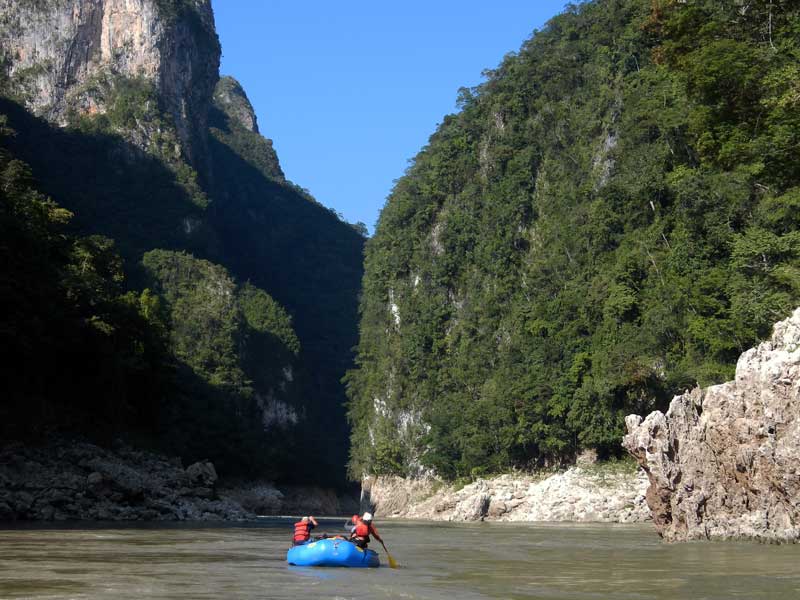
The Usumacinta river trip is one of the classics in the world and not to be missed. Relax in the hot winter sunshine on giant beaches, swim in warm clean water, traipse through the tropical jungle to spot toucans and jaguar tracks, shreik from the dinosaur-like gaspy roars of howler monkeys, visit two major Mayan arqueological sites, and paddle through a some exciting whitewater in the canyon. Everyone is welcome: kayakers, IKers, oarsmen, and raft passengers. We plan to have several rafts to support our group, so even beginners can take a shot at paddling a kayak. We'll have at least two local Chol-speaking guides along with us for positive interactions and safety. The pace is relaxed, with one layover day planned. We have a full set of rafts, catarafts, kayaks and inflatable kayaks available and guides to cater to all groups needs. On some trips, it may be possible to join a Lacanjá trip beforehand for an amazing ~14-day Mayan jungle adventure!
Show your appreciation of a free-flowing Río Usumacinta and oppose the five dams that continue to be pursued by CFE (Comisión Federal de Electricidad). Please sign this petition against the dams and spread the word to garner more opposition!
MORE INFO ON THE USUMACINTA AND HISTORY:
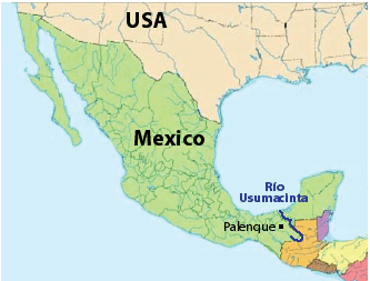
Río Usumacinta is the most voluminous river in all of Mexico and Central America and forms part of the border between Chiapas and Guatemala. The river averages ~3000 cms (~100,000 cfs) in the rainy season and 800-1500 cms (30,000-50,000 cfs) in the drier winter months. Although it is generally flat moving water, there are a number of class II and III rapids, at least four of which rate III or III+. Due to the reliable big water, canyons, Mayan ruins, rapids, warm winter temperatures and other interesting aspects along the river, it became one of the most sought-after rafting journeys in the world starting in the 1970s, and a prime winter destination of many Grand Canyon guides. The rafting industry ended during the Guatemalan civil war when militants took refuge in the jungles near the banks of the river and sometimes robbed rafting groups. Now well after the war, the dangers have subsided. Guatemalan soldiers and caretakers stationed by Piedras Negras keep the region safe. SierraRios has run dozens of raft/kayak expeditions on this river without problem starting in 2010 - we are the only outfitter to offer trips. See a video of what the river is like at VIDEO. See summary slideshows of some of these trips at: Slides 2017a ; Slides 2017b(kids) ; Usumacinta2011a and Usumacinta2011b. See an article Rocky wrote about one of the recent descents published in American Whitewater. Read some comments from participants. [For an excellent book discussing all aspects of this river including the assaults, rapids, the Maya, trade routes, ruins, plans for damming, and wildlife, see Christopher Shaw's Sacred Monkey River.]
OTHER ATTRACTIONS: Chiapas is full of natural wonders and Mayan ruins. See this slideshow for a taste of a few main attractions. While you are down there, you definitely will want to visit the ruins of Palenque and possibly also check out some other paddling runs. Get a copy of the Mayan Whitewater guidebook or check out short descriptions on Greg Schwendinger's MayanWhitewater.com website. There are many to consider includng the class III Río Chocoljá and class III-IV Río Shumuljá, as well as AguaAzul (see VideoGuide_AguaAzul).
TENTATIVE ITINERARY (Dec-Jun):
The itinerary below is a general plan for a 7-day trip at medium-low water. This is often the itinerary for most trips launching during the drier season Dec-May [though some trips may be only 6 days; and others 8 days; many high water trips (Jul-Nov launches) will be only ~6 days]. Usually we add 2 additional days for visiting Palenque ruins and rafting AguaAzul/Shumuljá for a 9-day itinerary. For a private group, the itinerary may be modified to anywhere between 5 and 10 days and can include pickups at Villahermosa, Cancún, or TuxtláGutierrez and visits to Bonampak (before trip), Tikal (after trip), or other sites. Such trips can also start at points upriver on Ríos Lacantún, Lacanjá, or Pasión.
DAY 0: fly into Villahermosa; transport to Palenque (1.6 hr); night in Hotel Lacandonia or other
DAY 1: service begins; drive Palenque to Frontera (3.5 hr); visit Bonampak; finish rigging; bungalow Frontera; 0 km
DAY 2: paddle to Yaxchilán camp; tour the ruins Yaxchilán; class I; 20 km
DAY 3: Chicozapote (III-); Big Springs; to El Playón ; class II-III; ~45 km
DAY 4: Jungle lagoon hike; Caribe (II+); Cenote Tumbado; camp at Piedras Negras; 14 km
DAY 5: LAYOVER; tour the ruins of Piedras Negras, play in the water, Cenote Seco hike or RELAX
DAY 6: Cola del Diablo (III); Cascada Busiljá; Río Chocoljá; enter Gran Cañon; La Linea (III+); Whirlpool (III); 38 km
DAY 7: finish Gran Cañon; San Josecito (III); San José (III+); explore cave; end/derig; 26 km [service ends back in Palenque]
DAY 8: optional: visit Palenque ruins; dinner at El Panchán; Don Mucho live music
DAY 9: optional: raft Río Shumuljá and visit Agua Azul
DAY 0: If flying, you should arrive to Villahermosa or Palenque this day or earlier. You can take a taxi or bus (1.6 hr) to your hotel in Palenque and meet the trip leader and select some personal rental gear. There are ATMs available to get Mexican pesos (MXN).
DAY 1: This is the departure day. We rendezvous at 8 am at the storehouse (or pick you up at your hotel) and take the van for the 3.5-hr drive to Bonampak (with stop for brunch), then visit this Mayan site with its incredible murals. We then arrive to Frontera Corozal (our put-in on the Mexican side of the Usumacinta) and continue rigging, adjust kayaks, have a safety talk, and then a restaurant dinner. Camp or stay in bungalow. Restaurant dinner. 0 km
DAY 2: We will spend the morning paddling the 20 km to the magnificent Mayan ruins of Yaxchilán where we'll have lunch and set up camp (we have a special arragnement with the park). The afternoon is spent touring the ruins of Yaxchilán. We'll have a traditional Mayan/Mexican feast for dinner. Tamales/burritos. ~20 km
DAY 3: In the morning we'll paddle through the first big rapid of the trip (Chicozapote; class II-III), have lunch and stop at Big Springs where we'll refill water, bathe and swim, and hopefully make it down to the giant El Playón beach for camp. Steak/salmon. ~45 km
DAY 4: In the morning we'll do a hike into the jungle to a pristine lagoon and go for a swim. After lunch back at El Playón, we'll continue downstream past Arroyo Jerusalen and through the Rapidos Caribe, then stop and swim at the Cenote Tumbado spring just before arriving to Piedras Negras camp. Fajitas/burritos.
DAY 5: LAYOVER. We'll check in with the military and caretakers at Piedras Negras and spend the morning hiking around the ruins, and in the afternoon either do some more hiking (to the dry cenote) or playing in the water, practicing kayak rolls and other paddling techniques, or simply relaxing in camp. Lasagna or enchiladas; ~15 km
DAY 6: We'll pass El Porvenir then enter a class II gorge with Cola del Diablo (III) and several other rapids, and arrive at and explore the beautiful travertine waterfalls of Cascada Busiljá that drop directly into the Usumacinta. After lunch, we continue downstream, sometimes stopping to explore/kayak the final few drops on Río Chocoljá (if there are interested kayakers on the trip; to do so requires a paddle/hike upstream). We then enter the main Gran Cañon de San José and paddle through several big rapids: La Linea (III+), Baluarte (II-III) and Whirlpool (III-). We'll set up camp a more open section before the next gorge and big rapids. Fajitas / fish or other. ~35 km
DAY 7: We'll paddle through the final part of the Gran Cañon San José with two of the biggest rapids the river has to offer: San Josécito (III) and San José (III+), and then the final rapid, White Wall (II-). The remainder of the river has no rapids as it goes through the final gorge at Boca del Cerro, but we may still stop at a crystal clear side stream for a swim and/or explore one of a few caves where the gigantic Boca del Cerro/Tenosique dam is to be built. We'll then arrive at the take-out around mid-day, de-rig, clean and dry items (~2 hr), and drive back to Palenque (1.5 hr). Restaurant Palenque; ~30 km
Return to Palenque. Folks will generally stay at a hotel in Palenque or in cabañas at El Panchán. Optional excursions to Palenque ruins and/or Agua Azul often are scheduled the days before or after the main river trip. The group usually gathers for a restaurant dinner the day after the trip at Don Mucho's to listen to live music, dance, and enjoy the fire show. It is possible for participants to depart.
DAY 8: PALENQUE RUINS: Often folks like to relax the morning after the expedition, but usually this day we plan a visit to the magnificent ruins of Palenque either in the morning or the afternoon.
DAY 9: SHUMULJÁ/AGUA AZUL: Most visitors to Palenque also plan to visit the Cascadas Agua Azul, which are incredible to see especially when the water is blue-turquoise. We generally like to arrange a raft run of Ríos Shumuljá (class III) this day for some fun turquoise-water rapids and to visit the final most impressive falls of Agua Azul.
DAY 10+ (Optional): CHOCOLJÁ: Other rivers in the area can be paddled as day-trips, including the fabulous class III+ Salto Chocoljá section, Upper Tulijá (class IV), lower Tulijá (class IV), Chacamax (class III), Lacanjá (III-IV), Paxilhá (IV-V), main Chocoljá (III), Bascán (III-IV falls), Corostic (IV-V), or Jataté (IV+).
We will help arrange to get you back to the Villahermosa airport if you need to, but it's not covered in the price of the trip. It is a 1 hr 40min drive. Generally, a taxi is ~1400p; ADO offers a convenient bus service at ~400p and there are collectivos that can take you there for ~300p most times of the day.
TRANSPORTATION
The trip contribution includes getting you from Palenque to Frontera (the put-in) and back to Palenque from the take-out. Palenque is a small city with many hotels and restaurants and is the base for many travelers visiting the ruins of Palenque, Bonampak, Yaxchilán, and the Cascadas Agua Azul and Misol-Ha. If arriving by plane, there are several airports to consider flying to:
Palenque (PQM) airport is small and only serviced by Interjet to/from Mexico City (flights 2X per week - generally Wednesdays and Saturdays). If you're based in Mexico City, this is a convenient option. If you are flying from the USA or Europe, it is much easier to find flights into Villahermosa.
Villahermosa (VSA) airport is a 1.6 hr drive ride from Palenque. VSA is serviced by United, American, AeroMexico, Volaris, VivaAerobus and other Mexico-based carriers (also as partner airlines). If several of the group are arriving at VSA airport, we can arrange to pick you up (a little extra fee), but you can always get a taxi from there to Palenque (~1200p) or take the ADO bus service (~350p; generally departs every hour from 7am - 9pm). If you have a vehicle, you can meet us in Palenque and possibly get a discount for use of your vehicle in shuttle.
Tuxtla Gutiérrez (TGZ) airport is approximately a 5 hr drive from Palenque. The route between Tuxtla and Palenque passes San Cristóbal de las Casas, a charming colonial city very popular with tourists, and the Cascadas Agua Azul, another of the major tourist destinations in the region.
Cancún (CUN) airport has international flights from just about everywhere, is serviced by most international US carriers, and generally is the most inexpensive to fly to. Although it is pretty far away (~10 hr by bus to get to Palenque), you would get to see more of the attractions on the Yucatán peninsula, including it's famed beaches, cenotes, and various post-classic Mayan sites (Chichén Itzá, Uxmal, and Tulum, for example) before or after the trip. If you have a group arriving to Cancún, we can arrange a special van to take you to some of the peninsular sites and then to Palenque and the river.
COST
This trip is being run because it is one of the most incredible in the world and more paddler visitation is needed to help raise awareness. More ecotourism income to the region and appreciation of the natural resource will help stop the river's destruction with dams. Our general pricing guidelines are found at the following link: Contribution guidelines: General
Special discounts are sometimes offered to folks on our email list, so you are encouraged to sign up (Email List info).
RESERVATIONS
You will need to provide a deposit to reserve your place on the trip ($500). Please email a note about your paddling background and your intent to join the trip to reservations@sierrarios.org. Full contribution must be received at least 2 weeks before the trip. See PAYMENTS for payment options.
A trip will definitely occur with a minimum of 4 full-paying participants. Other launch dates can be arranged for groups of 4 or more. Weekly trips in the main sesaon are generally scheduled for departure on Sunday.
To make a deposit and/or payment, click PAYMENTS.
TRIP LEADERS (one or more of the following individuals):
The policy we will take on the trip is that the trip leader will have main authority when it comes to decisions for the group regarding river progress, camp, safety, etc. If a participant has overestimated their ability to row or kayak, he/she may be mandated to ride on a raft and/or be assessed other penalties. You should have an easygoing personality and expect to socialize with a diverse group for the week of the trip. If you are concerned about this issue, consider arranging a special private trip - or if you're an experienced group of boaters, utiliizing our Outfitting Services.
(1) Rocky Contos, often the trip leader, is fluent in Spanish, explored every river in Mexico, solo kayaked the entire Jataté-Lacantún-Usumacinta in early 2010, reopened the river by working with local communities, successfully led raft/kayak trips down the Usumacinta in Dec2011, Jan2012, Dec2012, and many more times in the following years (a total of 15X by 2021), co-authored the guidebooks to Chiapas and the Sierra Madre Occidental, and is preparing guidebooks for the rest of Mexico. He producedand narrated an Usumacinta video, as well as AguaAzul and the Shumuljá. In Mexico, Rocky has ~110 probable first descents covering ~8,000 km of river and ~55,000 m of drop and has paddled every major river in the country. He has paddled over 200 multi-day journeys on rivers, with dozens in the range of 5-22 days. Rocky discovered the most distant source of the Amazon in 2012 and completed the first source-to-sea descent of the river, including the full Mantaro. Rocky is trained in swiftwater rescue (RRC-Pro from SierraRescue3) and WFR (Wilderness First Responder). He is the primary organizer of all trips and if present, will either be safety kayaking or rowing/captaining a raft. For more info on Rocky, see Bio_Rocky.
(2) German Arroyo (Mexican guide), sometimes trip leader or co-leader, is a bilingual raft guide from Mexico City who has paddled the Usumacinta >20 times (as of 2021) and co-guided or organized several SierraRios Usumacinta trips. He will usually be rowing a raft, but can also kayak the river if an appropriate oarsperson takes the helm of his raft.
(3) Miyaya Urbina (Mexican guide), is a Spanish-speaking raft guide from Palenque who has guided the Usumacinta >40 times, mostly in the 1990s, and co-guided several SierraRios Usumacinta trips. She was the first female Mexican river guide in the country. Miyaya and her family have lived in Palenque for generations and were some of the original helpers for the Usu trips in the 1980s-1990s. She is the main logistics coordinator for all trips and stores gear at the Palenque house and a nearby ranch. Miyaya will often be driving shuttle and helping out at the start and end of trips. If guiding, Miyaya will usually be rowing a raft or cataraft.
(4) René Lopez (Local Chol guide). René is Sunción's nephew and also did his first trip in 2012. He doesn't speak English, but rows well, is a hard worker, is employed at the Yaxchilán reserve where is found much of the year, and is happy to talk to you in Spanish. So far (Jul2016), René has helped guide 8 trips down the Usumacinta. .
(5) Sunción Lopez (Local Chol guide). Sunción will generally help guide and/or lead all future Usumacinta trips. Sunción came on a January 2013 Usumacinta trip and learned much about the river and rowing. He was a natural. His Chol bilinguality and familiarity with residents along the river adds safety to any trip and he provides additional information on points of interest and the flora/fauna of the jungle. Since that first trip, he's helped guide 8 more Usumacinta trips, a Lacanjá-Lacantún trip, Shumuljá trips, has paddled several rivers in central Mexico, and continues to aspire to be a great guide. Read more about Sunción here.
(6) Gadi San Martín (Mexican guide), is a Spanish-speaking raft guide from Cuernavaca who has helped guide the Usumacinta >6X times. Gadi will be found rowing a raft - or kayaking if there are sufficient other oarsmen along.
(7) Other guides: Other river guides may be helping out or leading the trips, including Ariel Diaz, Alejandro Quiroga, Uriel Valdez, or Will Blackstock.
Personality/Experience:
No river rafting experience is required to join a trip. However, you should be comfortable camping and in good physical condition, and also should have an easygoing attitude in order to get along with a diverse group on a Grand Canyon-style trip for an extended period. If you are concerned about the latter issue, consider arranging a private trip, or if you're an experienced group, contracting our Outfitting Services. You don't need to be bilingual but it is helpful and more fulfilling to communicate with local residents when we meet them. Every participant must sign a liability waiver.
Everyone joining SierraRios trips should have an interest in river conservation and help us on our mission to document the river further, talk to residents, publicize the planned dams, and help train local guides. We welcome competent boaters. If you want to kayak through the rapids, you should have some prior training, experience and a solid roll. If you want to row a raft, you must have adequate experience rowing class III rivers. Comparable or more difficult rivers are the Colorado (Grand Canyon), Main Salmon, Green (Deso/Gray), and Rogue. In general, the pace is relaxed with layover days planned, but there may be some long days on the water.
The policy we will take on the trip is that the trip leader will have main authority when it comes to decisions for the group regarding river progress, camp, etc. If a participant has overestimated their ability to row or kayak, he/she may be mandated to ride on a raft and/or be assessed other penalties. Trip leader decisions can be vetoed by a majority vote of the group. Any participant always has the right to leave the trip if they so desire, but no refund is due.
HEALTH
Guides trained in wilderness first aid will provide medical attention to those suffering illness or injury. We will have one major first aid kit. Our first aid kit will have some pharmaceuticals such as anti-inflammatories (ibuprofen, aspirin, paracetamol), anti-allergy pills, immodium/PeptoBismol/Tums, and antibiotics, as well as items/implements to treat wounds and other injuries. If you think you might suffer from something in particular, please bring your own pharmaceuticals. Probably the most common ailment folks suffer from is gastrointestinal distress or traveler's diarrhea. You should try to minimize chances of contracting it by avoiding potentially dirty foods before the trip. During the trip, we employ NPS-recommended sanitization methods in all our food and water preparations/treatments. If you do end up suffering diarrhea, vomiting, and/or nausea for more than a day, you should consider taking ciprofloxacin for a few days (this often makes the problem go away quickly).
Río Usumacinta is located in the jungles of Chiapas with certain health risks. We recommend that you read the CDC page regarding travel to Mexico and to Guatemala (because the Usumacinta runs along the border of both countries), consider the health advice, and visit your doctor before your trip. In general, visitors to the jungle areas of Chiapas should be vaccinated against Hepatitis A and possibly Typhoid. You might consider getting Rabies immunization as well. Although the area has had cases of Malaria, we generally encounter few mosquitos on the trip and you can protect yourself with repellent, clothes and by sleeping in a tent. To be extra cautious, you might consider anti-malarial medication.
In the event of a critical injury, we will raft the person to the nearest road access and contract a ride out. We will carry a cell phone, satellite phone, and/or SPOT device for communicaton regarding emergencies and changes of plan. Evacuation and medical costs are the responsibility of the participant. We therefore highly recommend that all participants obtain a travel insurance policy such as those offered through Squaremouth, Tavelguard, or Travelsafe.
SAFETY & LIABILITY
All participants on the expedition will be required to sign a liability release similar to those for any outfitter. As guides, we are there to help get you safely to the river, down it, and back out, but due to the inherent risk of whitewater expeditions, we cannot guarantee against accidents, espcially if you are in control of your craft. If you are concerned about the whitewater or other aspects on this river, it is ultimately your responsibility to make appropriate decisions whether to run the rapid or not and to stay close to someone who can watch and oversee you (if you desire that level of protection). If an accident occurs, we will do all in our power to help you, see that proper care is rendered, or evacuate you if need be. Other problems may occur that are out of our control. Again, we highly recommend that all participants obtain a travel insurance policy (see Squaremouth, Tavelguard, or Travelsafe). You are responsible for personal equipment loss, missed flights, and evacuation/medical costs.
The Usumacinta is generally a safe place these days, owing to the facts that the Guatemalan civil war and Zapatista uprising are distant memories, caretakers/guards/police are stationed at the Mexican reserves, and the Guatemalan military is now stationed by Piedras Negras and regularly travel up and down the river. Thousands of tourists travel down the river each year on motorized lancha to visit Yaxchilán. Although we have never had assaults or problems on any Usumacinta trip run by SierraRios (a total of >25 trips run between 2010-2018), we continue to take several precautions to avoid any problems, including (a) having local Chol-speaking guides along on our trip, (b) selecting safer camps, (c) avoiding areas that might be prone to bandidos/assault, (d) knowing the current situation in the area, and (e) paying for special security. We strongly recommend against anyone venturing down the river without taking such precautions.
You might be concerned about the violence in Mexico surrounding the drug war that has been in the news a lot in the past decade. This violence is generally restricted to drug traffickers (narcotraficantes) and those associated with them, including law enforcement. As such, we are not likely to be harassed or molested in any way related to the drug war. For further discussion of the drug war and safety concerns, click here.
CLIMATE
Consult the climate chart to get an idea of what the weather might be like on the trip you plan to join. Dec-Jan are semi-dry times of the year with usually warm temperatures but some chance of storms. Feb-Mar-Apr are generally the driest months and getting very warm. In general, highs can be expected to be 24-33oC (76-92oF) and lows 17-24oC (62-76oF). When there are northern cold fronts blowing through, the highs can be as low as 70oF and it can be quite rainy. From Feb-Apr, there is less chance of rain, days are sunnier, and the temperatures are generally quite a bit higher. In the rainy season (Jun-Nov) expect lots of clouds and more rain. The water temperature in the river from Dec-Jun generally reflects the average temperature of the air.
Below are averages for Tenosique (at end of the trip, though it's often slightly cooler with more rain in Frontera):
| Jan | Feb | Mar | Apr | May | Jun | Jul | Aug | Sep | Oct | Nov | Dec | Avg/Total | |
| AvgHigh(°C) | 28 | 30 | 33 | 35 | 36 | 34 | 34 | 34 | 33 | 31 | 30 | 28 | 32°C |
| AvgLow(°C) | 19 | 20 | 21 | 23 | 23 | 23 | 23 | 23 | 23 | 22 | 21 | 19 | 22°C |
| AvgPrecip(mm) | 107 | 76 | 61 | 68 | 141 | 276 | 203 | 236 | 353 | 275 | 145 | 124 | 2068 mm |
| AvgRainDays | 10 | 7 | 5 | 4 | 7 | 16 | 17 | 17 | 19 | 15 | 11 | 10 | 12 days |
| AvgFlow(cfs) | 45000 | 37000 | 31000 | 25000 | 25000 | 55000 | 88000 | 88000 | 105000 | 110000 | 92000 | 65000 | 62000 |
| -------- | ------ | ------ | ------ | ------ | ------ | ------ | ------ | ------ | ------ | ------ | ------ | ------ | ------ |
| AvgHigh(°F) | 82 | 86 | 89 | 95 | 97 | 94 | 93 | 93 | 92 | 88 | 86 | 83 | 86°F |
| AvgLow(°F) | 66 | 68 | 70 | 74 | 74 | 74 | 74 | 74 | 74 | 72 | 70 | 67 | 70°F |
| AvgPrecip(in) | 4.2 | 2.9 | 2.3 | 2.7 | 5.6 | 10.9 | 8.0 | 9.3 | 13.9 | 10.8 | 5.7 | 4.9 | 81 min |
| AvgRainDays | 10 | 7 | 5 | 4 | 7 | 16 | 17 | 17 | 19 | 15 | 11 | 10 | 12 days |
| AvgFlow(cfs) | 45000 | 37000 | 31000 | 25000 | 25000 | 55000 | 88000 | 88000 | 105000 | 110000 | 92000 | 65000 | 62000 |
BUGS
You should take precautions against bug bites. Midges (aka no-see-ems; jejenes), chiggers, and mosquitos are the most frequent culprits. PROTECT YOURSELF and you won't suffer so much! Put on repellent (REPEL works extremely well) at the put-in and as soon as we land at camp or the take-out, and also in the morning after getting out of your tent. Wear light airy pants and long-sleeve shirts. Choose Bugs-Away clothing or make your own by soaking your clothing in permethrin. Avoid walking around grass where cattle are common and chiggers hang out. Note: if you're not immunologically adapted to the area, the midge bites often lead to very itchy red welts!
WATER LEVELS
Water levels on the Usumacinta are generally medium in Dec-Jan, and low Feb-May. Low water is nice in the sense that more beaches are exposed, the river runs clearer, and there are more features in rapids such as surf waves. The river can be done any time of year though, and most of the river is not much more difficult at high water, though bigger whirlpools develop, swims in the rapids can be very dangerous, and some camps will not be available (be extra careful in the Gran Cañon de San José, where huge whirlpools can develop at high water and flip even 16' rafts!).
Historical flow hydrographs for the Usumacinta and some upstream tributaries can be viewed at the following links:
Historical flow: Usumacinta (Boca del Cerro)
Historical flow: Lacantún (Agua Verde II)
Historical flow: Chixoy/Salinas
Historical flow: Ixcán
Historical flow: Xalbal/Chajul
You can see the water levels over the past few weeks at Greg Schwendinger's Mayan Whitewater website (scroll down once you load it). Below you can see the average flows through the year (note 1000 cms = 35000 cfs):
Avg.jpg)
FOOD/ALCOHOL/WATER
(click here)
CHORES, TOILET AND BATHING
(click here)
WHAT TO PACK:
(click here)
BOATS AVAILABLE FOR THIS TRIP
(click here)
PLANNED DAMS FOR THE USUMACINTA
CLICK HERE
VOICE OPPOSITION TO THE TENOSIQUE DAM! Sign a petition against the dams. Send your comments to Presidente Enrique Peña Nieto. A sample letter is below (the one I sent):
----------------------------------------------------------------------------------------------------------------
.A FEW COMMENTS FROM PAST PARTICIPANTS:
"Thank you Rocky! You and your team do a world class job. Memories for a lifetime." [14Mar2017 Usumacinta trip]
Brian Kennedy; aircraft mechanic; CA
"This was the holiday of my life! Hehe , yeah, I guess my profile picture proves that.." [23Mar2017 Usumacinta trip]
Isabelle Hardemann; tours and dive master; Bali
"Eli was asking yesterday - when are we going to do this trip again? It was an incredible experience! " [23Mar2017 Usumacinta trip]
Kathryn Mengerink; Executive director Watt Institutte (nonprofit); CA
"Beautiful river with a ton of great “extras”: ruins, wildlife, waterfalls, etc. The rapids were pretty doable, but for me the whirlpools were a new thing and pretty crazy (especially in the packraft). I chose to take photos from atop rafts for the last couple of days, but Bryan rode the whole river in his packraft. Awesome side excursions, the boys loved riding up the Chocolja river and running the last couple of rapids." [30Dec2016 Usumacinta trip; returned for 27Dec2017 trip]
Molly Ferrer; school board Denver and rafter/packrafter; CO
"Wonderful and enlightening - and not too arduous! Journey into the world of the Mayan civilization.. loved the river experience.. what a terrific trip this was..." [23Dec2012 Usumacinta trip]
Steven Hancoff and Beth Troy; musician, rolfer and aromatherapist; SC
"Hi Rocky, Thanks again for a sensational and unforgettable trip. You did such an amazing job organizing. I especially am psyched to have met you and to have another kayak friend/guide to work with. You guiding me off the waterfall was a big highlight... Erik." [Jan2012 Usumacinta trip]
Erik Weihenmayer, blind mountaineer/author and budding kayaker; CO (see www.TouchTheTop.com)
"You led one of the best trips I've ever been on... and I've been on a lot. " [Jan2012 Usumacinta trip]
Chris Wiegand, former olympic runner and C1 paddler, founder of Sportainability and guide for Erik Weihenmayer; CO
"Thanks for everything man, it was a trip of a lifetime ... We´ll be in touch and I look forward to conquering new rivers in the future. Salud, Eric" [Jan2012 Usumacinta trip]
Eric Bach, Modern Gypsy (see www.TheModernGypsies.com); CA
"Hey Rocky, Thanks for the great trip... Looking forward to another trip down the road. John" [Jan2012 Usumacinta trip]
John Post, Modern Gypsy (see www.TheModernGypsies.com); CA
"Fabulous trip. Expect to hear more from Team Weihenmayer in the future... Cheers, Rob. " [Jan2012 Usumacinta trip]
Rob Raker, climber extraordinaire and guide for Erik Weihenmayer (also see here); CO
"Thanks again for the great tour and the late-night excitement, Greg" [Dec2011 Usumacinta trip]
Greg Scwhendinger, kayak explorer of Chiapas and Central America (see www.MayanWhitewater.com); Antigua(Guatemala)
"The trip on the Usumacinta was great, I am very happy that I paddled the river and did not sit on the raft." [2013a Usumacinta trip]
Stanislav Chladek, former C1 world champion and author of Exploring Mayan Ritual Caves; Czech Republic
"Thanks for everything, Rocky! What a blast that all was. When's our next trip?!! -Suzy" [Jan2012 Usumacinta trip]
Suzy Garren (Oakland, CA), former Grand Canyon trip participant; CA